File:Usgs map azimuthal equidistant.PNG
পরিভ্রমণে চলুন
অনুসন্ধানে চলুন
এর চেয়ে বেশি রেজোলিউশন লভ্য নয়।
Usgs_map_azimuthal_equidistant.PNG (৪৮৭ × ১৬২ পিক্সেল, ফাইলের আকার: ৪৬ কিলোবাইট, এমআইএমই ধরন: image/png)
ক্যাপশনসমূহ
ক্যাপশন
এই ফাইল কি প্রতিনিধিত্ব করছে তার এক লাইন ব্যাখ্যা যোগ করুন
- (see below: Enlarged view)
সারাংশ[সম্পাদনা]
| বিবরণ |
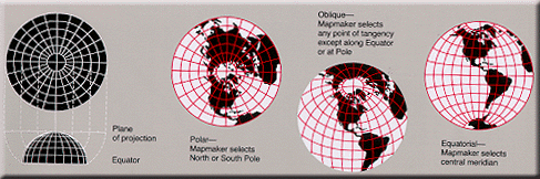
English: Condensed explanation of azimuthal-equidistant projection maps, colored as smaller PNG image, from larger, wider USGS file of GIF format. See enlarged view below, using a wikitable to expand beyond original size. |
| তারিখ | |
| উৎস |
derivative from USGS image file (with map sections colored red/white), |
| লেখক | User:Quadell, re-coloring US Government USGS image. |
| অন্যান্য সংস্করণ |
Taller arrangement of globes with enlarged lettering/clarified, up to 3x faster (GIF format): |

|
This map image could be re-created using vector graphics as an SVG file. This has several advantages; see Commons:Media for cleanup for more information. If an SVG form of this image is available, please upload it and afterwards replace this template with
{{vector version available|new image name}}.
It is recommended to name the SVG file “Usgs map azimuthal equidistant.svg”—then the template Vector version available (or Vva) does not need the new image name parameter. |
Enlarged view[সম্পাদনা]
 Explanation of azimuthal-equidistant projection. |
লাইসেন্স প্রদান[সম্পাদনা]
| আমি, এই কাজের স্বত্বাধিকারী, এতদ্দ্বারা আমি এই কাজকে পাবলিক ডোমেইন লাইসেন্সের আওতায় প্রকাশ করলাম। এটি বিশ্বব্যাপী প্রযোজ্য হবে। কিছু দেশে এটি আইনত সিদ্ধ নাও হতে পারে, যদি তাই হয়: আমি যে-কাউকে এই কাজটি যেকোনো উদ্দেশ্যে, বিনাশর্তে ব্যবহারের অনুমতি প্রদান করছি, যদি না সেই শর্তগুলো আইনত প্রয়োজনীয় হয়। |
This image is in the public domain in the United States because it only contains materials that originally came from the United States Geological Survey, an agency of the United States Department of the Interior. For more information, see the official USGS copyright policy.
|
ফাইলের ইতিহাস
যেকোনো তারিখ/সময়ে ক্লিক করে দেখুন ফাইলটি তখন কী অবস্থায় ছিল।
| তারিখ/সময় | সংক্ষেপচিত্র | মাত্রা | ব্যবহারকারী | মন্তব্য | |
|---|---|---|---|---|---|
| বর্তমান | ১৪:২৫, ১৭ ফেব্রুয়ারি ২০০৫ | ৪৮৭ × ১৬২ (৪৬ কিলোবাইট) | Quadell (আলোচনা | অবদান) | World map projection ([http://erg.usgs.gov/isb/pubs/MapProjections/projections.html source)]{{PD-USGov-USGS}}Category:World mapsCategory:Map projectionsCategory:Map diagrams |
আপনি এই ফাইলটি প্রতিস্থাপন করতে পারবেন না।
ফাইলের ব্যবহার
নিম্নলিখিত 2টি পাতা এই ফাইল ব্যবহার করে:
ফাইলের বৈশ্বিক ব্যবহার
নিচের অন্যান্য উইকিগুলো এই ফাইলটি ব্যবহার করে:
- en.wikipedia.org-এ ব্যবহার
- et.wikipedia.org-এ ব্যবহার
- fi.wikipedia.org-এ ব্যবহার
- ja.wikipedia.org-এ ব্যবহার
- ko.wikipedia.org-এ ব্যবহার
- lt.wikipedia.org-এ ব্যবহার
- zh.wikipedia.org-এ ব্যবহার