File:Ushas Mons.jpg
跳转到导航
跳转到搜索

本预览的尺寸:480 × 600像素。 其他分辨率:192 × 240像素 | 384 × 480像素 | 614 × 768像素 | 819 × 1,024像素 | 1,638 × 2,048像素 | 4,096 × 5,120像素。
原始文件 (4,096 × 5,120像素,文件大小:5.17 MB,MIME类型:image/jpeg)
说明
说明
添加一行文字以描述该文件所表现的内容
摘要
[编辑]
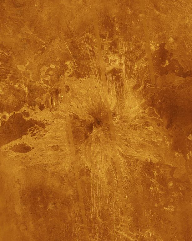
| 描述 | Ushas Mons, a 2-kilometer-high (1.25 mile) volcano in the southern hemisphere of Venus is shown in this Magellan radar image. The image is centered at 25 degrees south latitude, 323 degrees east longitude, and shows an area approximately 600 kilometers (360 miles) on a side. The volcano is marked by numerous bright lava flows and a set of north-south trending fractures, many of which appear to have formed after the lavas were erupted onto the surface. In the central summit area, however, younger flows remain unfractured. An impact crater can be seen among the fractures in the upper center of the image. The association of faulting and volcanism is common on this type of volcano on Venus, and is believed to result from a large zone of hot material upwelling from the Venusian mantle, a phenomenon known on Earth as a "hot spot." Simulated color is used to enhance small-scale structures. The simulated hues are based on color images recorded by the Venera 13 and 14 landing craft. The data were acquired during the third eight-month cycle of Magellan's radar mapping, which ended in September 1992. Several narrow gaps in the Magellan coverage are filled with low-resolution radar data obtained by the Earth-based Arecibo radio telescope. The image was produced by the Solar System Visualization Project and the Magellan Science Team at the Jet Propulsion Multimission Image Processing Laboratory. The Magellan mission is managed by JPL for NASA's Office of Space Science. |
| 来源 | http://photojournal.jpl.nasa.gov/catalog/PIA00272 |
| 作者 | JPL/NASA |
| 此标签不表示文件的著作权状态。任何文件在附有此标签的同時还需要一个有效的著作权标签。请参阅许可协议说明页面以了解更多信息。 其他语言:
|
许可协议
[编辑]
| 本文件完全由NASA创作,在美国属于公有领域。根据NASA的版权方针,NASA的材料除非另有声明否则不受版权保护。(参见Template:PD-USGov/zh、NASA版权方针页面或JPL图片使用方针。) | ||
 |
警告:
|
文件历史
点击某个日期/时间查看对应时刻的文件。
| 日期/时间 | 缩略图 | 大小 | 用户 | 备注 | |
|---|---|---|---|---|---|
| 当前 | 2012年2月9日 (四) 17:32 | | 4,096 × 5,120(5.17 MB) | Lotse(留言 | 贡献) | higher resolution |
| 2007年11月24日 (六) 23:48 |  | 516 × 645(47 KB) | Lotse(留言 | 贡献) | {{Information |Description= Ushas Mons, a 2-kilometer-high (1.25 mile) volcano in the southern hemisphere of Venus is shown in this Magellan radar image. The image is centered at 25 degrees south latitude, 323 degrees east longitude, and shows an area |
您不可以覆盖此文件。
文件用途
没有页面使用本文件。
全域文件用途
以下其他wiki使用此文件:
- ar.wikipedia.org上的用途
- de.wikipedia.org上的用途
- en.wikipedia.org上的用途
- es.wikipedia.org上的用途
- fr.wikipedia.org上的用途
- gl.wikipedia.org上的用途
- he.wikipedia.org上的用途
- it.wikipedia.org上的用途
- nl.wikipedia.org上的用途
- pt.wikipedia.org上的用途
- uk.wikipedia.org上的用途
- www.wikidata.org上的用途
- zh.wikipedia.org上的用途