File:Usti nad Labem districts.png
跳转到导航
跳转到搜索
本预览的尺寸:800 × 548像素。 其他分辨率:320 × 219像素 | 640 × 438像素 | 957 × 655像素。
原始文件 (957 × 655像素,文件大小:34 KB,MIME类型:image/png)
说明
说明
添加一行文字以描述该文件所表现的内容
摘要
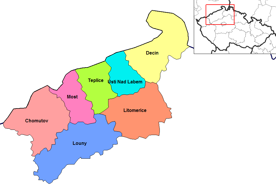
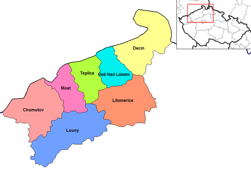
[编辑]| 描述 | Map of the districts of Usti nad Labem region of the Czech Republic. Created by Rarelibra 15:30, 2 January 2007 (UTC) for public domain use, using MapInfo Professional v8.5 and various mapping resources. |
| 日期 | 2007年1月2日 (原始上传日期) |
| 来源 | 无法识别来源。根据版权声明推断为其自己的作品。 |
| 作者 | 无法识别作者。根据版权声明推断作者为Rarelibra。 |
| 其他版本 |
.png)
许可协议
[编辑]
| 我,本作品著作权人,释出本作品至公有领域。这适用于全世界。 在一些国家这可能不合法;如果是这样的话,那么: 我无条件地授予任何人以任何目的使用本作品的权利,除非这些条件是法律规定所必需的。 |
文件历史
点击某个日期/时间查看对应时刻的文件。
| 日期/时间 | 缩略图 | 大小 | 用户 | 备注 | |
|---|---|---|---|---|---|
| 当前 | 2023年6月5日 (一) 16:54 | | 957 × 655(34 KB) | Horecak(留言 | 贡献) | Reverted to version as of 14:37, 6 August 2015 (UTC) |
| 2023年6月5日 (一) 16:53 |  | 957 × 655(13 KB) | Horecak(留言 | 贡献) | Cropped using CropTool with lossless mode. | |
| 2015年8月6日 (四) 14:37 |  | 957 × 655(34 KB) | Alphathon(留言 | 贡献) | Cropped out unnecessary border | |
| 2007年1月2日 (二) 15:30 |  | 1,056 × 816(23 KB) | Rarelibra(留言 | 贡献) | Map of the districts of Usti nad Labem region of the Czech Republic. Created by ~~~~ for public domain use, using MapInfo Professional v8.5 and various mapping resources. |
您不可以覆盖此文件。
文件用途
全域文件用途
以下其他wiki使用此文件:
- ar.wikipedia.org上的用途
- bg.wikipedia.org上的用途
- br.wikipedia.org上的用途
- ca.wikipedia.org上的用途
- ce.wikipedia.org上的用途
- cs.wikipedia.org上的用途
- da.wikipedia.org上的用途
- en.wikipedia.org上的用途
- es.wikipedia.org上的用途
- fa.wikipedia.org上的用途
- frr.wikipedia.org上的用途
- fr.wikipedia.org上的用途
- gl.wikipedia.org上的用途
- hu.wikipedia.org上的用途
- it.wikipedia.org上的用途
- ka.wikipedia.org上的用途
- ko.wikipedia.org上的用途
- la.wikipedia.org上的用途
- lmo.wikipedia.org上的用途
- lt.wikipedia.org上的用途
- mk.wikipedia.org上的用途
- no.wikipedia.org上的用途
- or.wikipedia.org上的用途
- pam.wikipedia.org上的用途
- pl.wikipedia.org上的用途
- pnb.wikipedia.org上的用途
- pt.wikipedia.org上的用途
- ro.wikipedia.org上的用途
- ru.wikipedia.org上的用途
- simple.wikipedia.org上的用途
- sl.wikipedia.org上的用途
- sq.wikipedia.org上的用途
- sv.wikipedia.org上的用途
- uk.wikipedia.org上的用途
- ur.wikipedia.org上的用途
- vi.wikipedia.org上的用途
查看此文件的更多全域用途。