File:VAG Rad Karte.png
Jump to navigation
Jump to search
Size of this preview: 769 × 600 pixels. Other resolutions: 308 × 240 pixels | 616 × 480 pixels | 985 × 768 pixels | 1,280 × 998 pixels | 2,560 × 1,997 pixels | 3,053 × 2,381 pixels.
Original file (3,053 × 2,381 pixels, file size: 1.65 MB, MIME type: image/png)
Captions
Captions
Add a one-line explanation of what this file represents
Summary[edit]
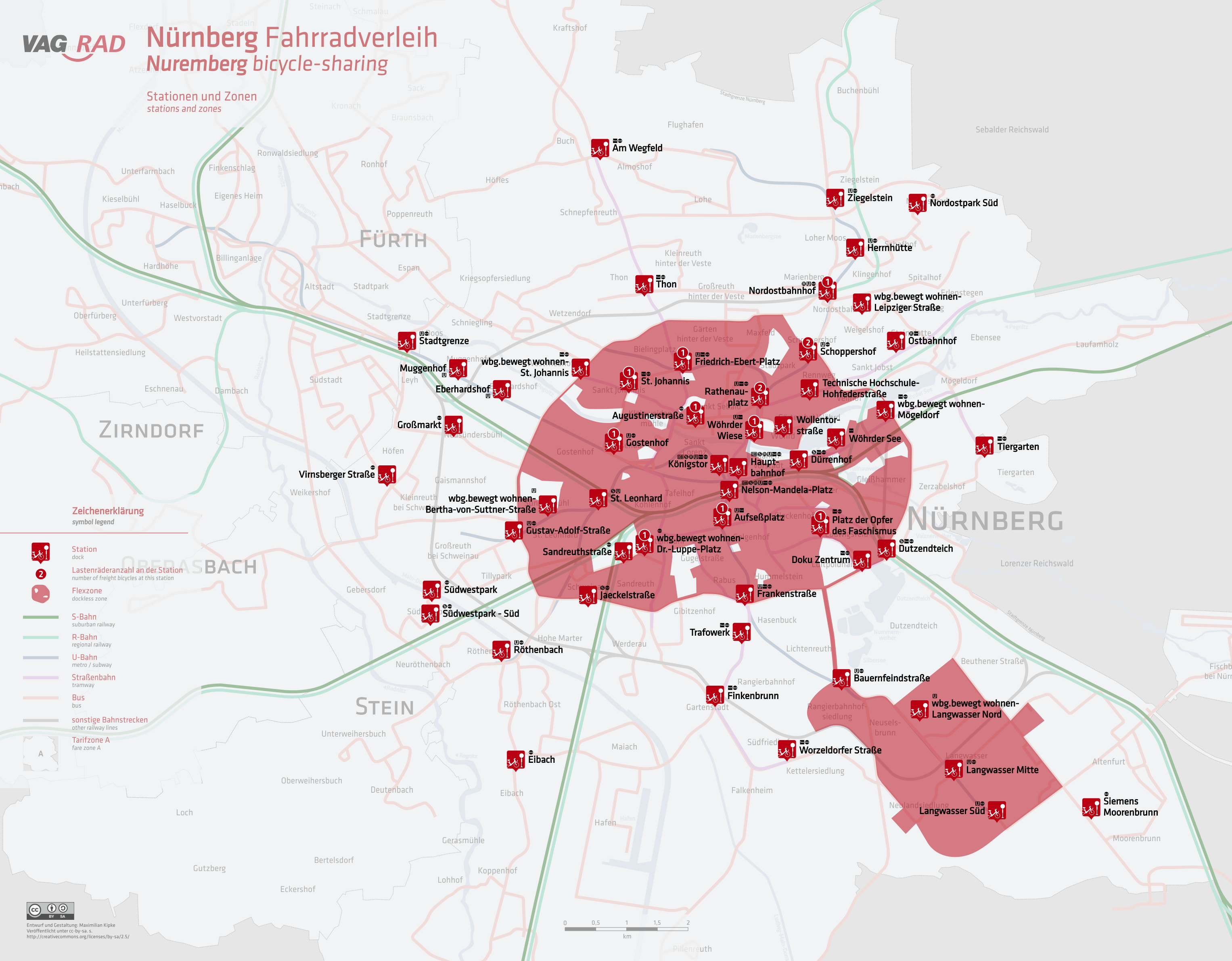
| Description | bicycle-sharing system in Nuremberg |
| Date | |
| Source | Own work |
| Author | HerrMay |
Licensing[edit]
I, the copyright holder of this work, hereby publish it under the following license:
This file is licensed under the Creative Commons Attribution-Share Alike 3.0 Unported license.
- You are free:
- to share – to copy, distribute and transmit the work
- to remix – to adapt the work
- Under the following conditions:
- attribution – You must give appropriate credit, provide a link to the license, and indicate if changes were made. You may do so in any reasonable manner, but not in any way that suggests the licensor endorses you or your use.
- share alike – If you remix, transform, or build upon the material, you must distribute your contributions under the same or compatible license as the original.
File history
Click on a date/time to view the file as it appeared at that time.
| Date/Time | Thumbnail | Dimensions | User | Comment | |
|---|---|---|---|---|---|
| current | 05:11, 26 September 2023 | | 3,053 × 2,381 (1.65 MB) | HerrMay (talk | contribs) | stationen hinzugefügt |
| 18:49, 15 March 2023 |  | 4,476 × 3,453 (2.6 MB) | HerrMay (talk | contribs) | TH Stationen hinzugefügt | |
| 05:11, 28 November 2022 |  | 4,476 × 3,454 (2.83 MB) | HerrMay (talk | contribs) | +Eibach | |
| 06:05, 24 October 2022 |  | 4,476 × 3,454 (2.82 MB) | HerrMay (talk | contribs) | Hauptbahnhof hinzugefügt | |
| 21:47, 2 July 2022 |  | 4,476 × 3,454 (2.81 MB) | HerrMay (talk | contribs) | + Südwestpark & Worzeldorfer Str. | |
| 20:15, 3 June 2022 |  | 4,297 × 3,453 (2.73 MB) | HerrMay (talk | contribs) | Bärenschanze entfernt | |
| 00:34, 6 May 2022 |  | 4,297 × 3,454 (2.73 MB) | HerrMay (talk | contribs) | Flexzone erweitert + Stationen hinzugefügt | |
| 01:15, 19 October 2021 |  | 4,182 × 3,237 (2.54 MB) | HerrMay (talk | contribs) | Lastenradsystem hinzugefügt | |
| 03:48, 18 August 2021 |  | 4,182 × 3,237 (2.5 MB) | HerrMay (talk | contribs) | Montessori Schule hinzugefügt | |
| 02:33, 11 May 2021 |  | 4,182 × 3,237 (2.49 MB) | HerrMay (talk | contribs) | Ostbahnhof und St. Leonhard hinzugefügt |
You cannot overwrite this file.
File usage on Commons
The following 30 pages use this file:
- User:Adeletron 3030/botgalleries/Sports/2021 August 17-19/Overflow 1
- User:Adeletron 3030/botgalleries/Sports/2021 October 17-19/Overflow 1
- User:Adeletron 3030/botgalleries/Sports/2022 July 1-2/Overflow 1
- User:Chumwa/OgreBot/Public transport information/2020 November 11-20
- User:Chumwa/OgreBot/Public transport information/2021 August 11-20
- User:Chumwa/OgreBot/Public transport information/2021 February 1-9
- User:Chumwa/OgreBot/Public transport information/2021 February 19-28
- User:Chumwa/OgreBot/Public transport information/2021 January 21-31
- User:Chumwa/OgreBot/Public transport information/2021 October 11-20
- User:Chumwa/OgreBot/Public transport information/2022 July 1-10
- User:Chumwa/OgreBot/Public transport information/2022 June 1-10
- User:Chumwa/OgreBot/Public transport information/2022 May 1-10
- User:Chumwa/OgreBot/Public transport information/2022 November 21-30
- User:Chumwa/OgreBot/Public transport information/2022 October 21-31
- User:Chumwa/OgreBot/Public transport information/2023 March 11-20
- User:Chumwa/OgreBot/Public transport information/2023 September 21-30
- User:Chumwa/OgreBot/Transport Maps/2020 November 11-20
- User:Chumwa/OgreBot/Transport Maps/2021 August 11-20
- User:Chumwa/OgreBot/Transport Maps/2021 February 1-9
- User:Chumwa/OgreBot/Transport Maps/2021 February 19-28
- User:Chumwa/OgreBot/Transport Maps/2021 January 21-31
- User:Chumwa/OgreBot/Transport Maps/2021 October 11-20
- User:Chumwa/OgreBot/Transport Maps/2022 July 1-10
- User:Chumwa/OgreBot/Transport Maps/2022 June 1-10
- User:Chumwa/OgreBot/Transport Maps/2022 May 1-10
- User:Chumwa/OgreBot/Transport Maps/2022 November 21-30
- User:Chumwa/OgreBot/Transport Maps/2022 October 21-31
- User:Chumwa/OgreBot/Transport Maps/2023 March 11-20
- User:Chumwa/OgreBot/Transport Maps/2023 September 21-30
- User:HerrMay
File usage on other wikis
The following other wikis use this file:
- Usage on de.wikipedia.org