File:VaFrontier2.jpg
Jump to navigation
Jump to search
No higher resolution available.
VaFrontier2.jpg (479 × 217 pixels, file size: 27 KB, MIME type: image/jpeg)
Captions
Captions
Add a one-line explanation of what this file represents

|
This historical map image could be re-created using vector graphics as an SVG file. This has several advantages; see Commons:Media for cleanup for more information. If an SVG form of this image is available, please upload it and afterwards replace this template with
{{vector version available|new image name}}.
It is recommended to name the SVG file “VaFrontier2.svg”—then the template Vector version available (or Vva) does not need the new image name parameter. |


Summary
[edit]
| Description |
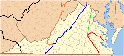
English: Lines show legal treaty frontiers between Virginia Colony and Indian Nations in various years. Red: Treaty of 1646. Green: Treaty of Albany (1684). Blue: Treaty of Albany (1722). Orange: Proclamation of 1763. Black: Treaty of Camp Charlotte (1774). Area west of this line in present-day Southwest VA was ceded by the Cherokee in 1775. |
| Date | (UTC) (Uploaded on Commons at 2012-01-07 00:14:24 (UTC)/Originally uploaded at 2009-07-23 14:00:15) |
| Source | I (Til Eulenspiegel (talk)) created this work entirely by myself. (Originally uploaded on en.wikipedia) |
| Author | Til Eulenspiegel (talk) (Transferred by Grondemar/Originally uploaded by Til Eulenspiegel) |
| Other versions | en:File:VaFrontier.jpg, does not include the 1774 frontier (black line on map) |
Licensing
[edit]
| This work has been released into the public domain by its author, Til Eulenspiegel. This applies worldwide. In some countries this may not be legally possible; if so: |
Original upload log
[edit]
The original description page was here. All following user names refer to en.wikipedia.
Upload date | User | Bytes | Dimensions | Comment
- 2009-07-23 14:00:15 | Til Eulenspiegel | 27476 | 479×217 | {{Information |Description = Lines show legal treaty frontiers between Virginia Colony and Indian Nations in various years. Red: Treaty of 1646. Green: Treaty of Albany (1684). Blue: Treaty of Albany (1722). Orange: Proclamation of 1763. Black: Trea
File history
Click on a date/time to view the file as it appeared at that time.
| Date/Time | Thumbnail | Dimensions | User | Comment | |
|---|---|---|---|---|---|
| current | 00:14, 7 January 2012 | | 479 × 217 (27 KB) | Grondemar (talk | contribs) | {{Information |Description ={{en|1=xxxxx}} |Source =xxxxx |Author =xxxxx |Date =xxxxx |Permission =xxxxx |other_versions =xxxxx }} xxxxx |
You cannot overwrite this file.
File usage on Commons
There are no pages that use this file.
File usage on other wikis
The following other wikis use this file:
- Usage on en.wikipedia.org
- Usage on hy.wikipedia.org
- Usage on it.wikipedia.org