File:ValcourIslandMap1776Overview.jpg
- Fichier
- Historique du fichier
- Utilisations locales du fichier
- Utilisations du fichier sur d’autres wikis
- Métadonnées

Fichier d’origine (837 × 529 pixels, taille du fichier : 213 kio, type MIME : image/jpeg)
Légendes
Légendes
Description
[modifier]| DescriptionValcourIslandMap1776Overview.jpg |
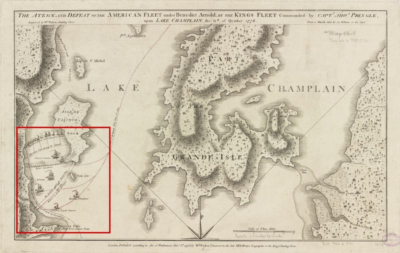
English: This is a 1776 map showing part of Lake Champlain and the action of the Battle of Valcour Island. The area showing the action has been highlighted with a red outline. The original map's border has also been cropped.
The map's caption reads: The attack and defeat of the American fleet under Benedict Arnold, by the King's fleet commanded by Capt. Thos. Pringle, upon Lake Champlain, the 11th of October, 1776 |
||||||||||||||||||||||
| Date | |||||||||||||||||||||||
| Source |
From the Boston Public Library Digital Map Collection (http://maps.bpl.org/). |
||||||||||||||||||||||
| Auteur |
creator QS:P170,Q8008902 |
||||||||||||||||||||||
Conditions d’utilisation
[modifier]| Public domainPublic domainfalsefalse |
|
Cette œuvre est également dans le domaine public dans tous les pays pour lesquels le droit d’auteur a une durée de vie de 100 ans ou moins après la mort de l’auteur. | |
| Ce fichier a été identifié comme étant exempt de restrictions connues liées au droit d’auteur, y compris tous les droits connexes et voisins. | |
https://creativecommons.org/publicdomain/mark/1.0/PDMCreative Commons Public Domain Mark 1.0falsefalse
Historique du fichier
Cliquer sur une date et heure pour voir le fichier tel qu'il était à ce moment-là.
| Date et heure | Vignette | Dimensions | Utilisateur | Commentaire | |
|---|---|---|---|---|---|
| actuel | 17 février 2009 à 21:15 |  | 837 × 529 (213 kio) | Magicpiano (d | contributions) | {{Information |Description={{en|1=This is a 1776 map showing part of Lake Champlain and the action of the Battle of Valcour Island. The area showing the action has been highlighted with a red outline. } |
Vous ne pouvez pas remplacer ce fichier.
Utilisations locales du fichier
La page suivante utilise ce fichier :
Utilisations du fichier sur d’autres wikis
Les autres wikis suivants utilisent ce fichier :
- Utilisation sur de.wikipedia.org
- Utilisation sur en.wikipedia.org
- Utilisation sur es.wikipedia.org
- Utilisation sur it.wikipedia.org
Métadonnées
Ce fichier contient des informations supplémentaires, probablement ajoutées par l'appareil photo numérique ou le numériseur utilisé pour le créer.
Si le fichier a été modifié depuis son état original, certains détails peuvent ne pas refléter entièrement l'image modifiée.
| _error | 0 |
|---|