File:Vali-cave2.jpg

Original file (1,365 × 1,024 pixels, file size: 111 KB, MIME type: image/jpeg)
Captions
Captions
Summary[edit]
| Description |
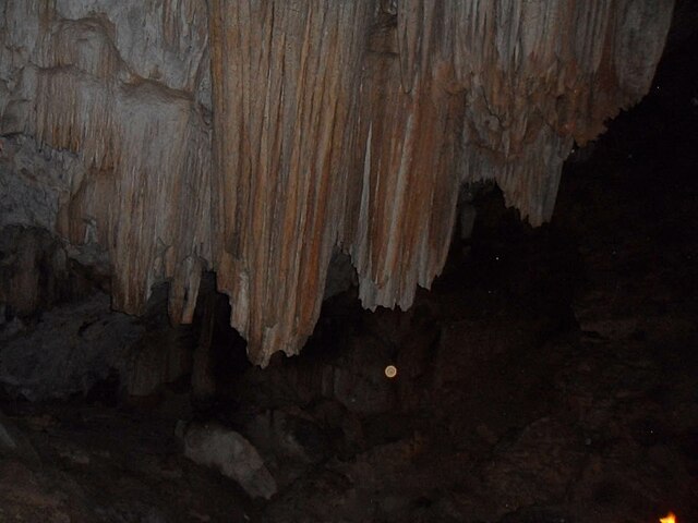
English: Gshnh village is five kilometers southwest of the cave, but the city and three kilometers south of Rudbar Gvrd Marlv coordinates of 55/52/49 east longitude and north latitude at an altitude of 1620 meters 20/34/36 located about 250 million years ago dissolution of calcareous stones and composed Ruteh Formation belongs to the Permian period and the first geological period is late.
The main hall and a few hundred meters and a height of 20 meters around the area of the sub forum that cold air has settled. Unfortunately these are very beautiful and large Astalakmyt Astalaktyt and it undergoes degradation due to the relatively easy access to abstracts and Stalactite and the many profiteers were stolen by looters break. Some evidence of being a cave man in the distant past Zi also has a story.فارسی: غار ولی در پنج کیلومتری جنوب غربی روستای گشنه رود از بخش رودبار شهرستان و سه کیلومتری جنوب گورد از بخش عمارلو با مختصات 55/52/ 49 طول شرقی و 20/34/36 عرض شمالی در ارتفاع 1620متری قرار دارد که حدود 250 میلیون سال قبل بر اثر انحلال سنگهای آهکی سازند روته تشکیل شده و متعلق به دوره پرمین و اواخر دوران اول زمین شناسی است.
یک تالار اصلی و چند تالار فرعی به مساحت حدود یکصد متر و ارتفاع 20 متر است که هوایی ساکن و سرد دارد. متاسفانه استالاکتیت ها و استالاکمیت ها ی بسیار زیبا و حجیم آن به دلیل دسترسی نسبتا آسان دستخوش تخریب سودجویان قرار گرفته و چکیده ها و چکنده ها ی فراوانی توسط غارتگران شکسته و به یغما رفته است. بعضی شواهد از انسان زی بودن این غار در گذشته های دور نیز حکایت دارد. |
| Source | http://govard.persiangig.com/pages.html |
| Author | http://govard.persiangig.com/pages.html |
Licensing[edit]

|
The copyright holder of this work allows anyone to use it for any purpose including unrestricted redistribution, commercial use, and modification.
Usage notes:
|
File history
Click on a date/time to view the file as it appeared at that time.
| Date/Time | Thumbnail | Dimensions | User | Comment | |
|---|---|---|---|---|---|
| current | 19:31, 25 July 2012 | | 1,365 × 1,024 (111 KB) | Hamid8s87 (talk | contribs) | {{Information |Description ={{en|1=Gshnh village is five kilometers southwest of the cave, but the city and three kilometers south of Rudbar Gvrd Marlv coordinates of 55/52/49 east longitude and north latitude at an altitude of 1620 meters 20/34/36 ... |
You cannot overwrite this file.
File usage on Commons
There are no pages that use this file.
File usage on other wikis
The following other wikis use this file:
- Usage on fa.wikipedia.org
- Usage on www.wikidata.org