File:Valle d'Aosta-Stemma.svg
Salta a la navegació
Salta a la cerca

Mida d'aquesta previsualització PNG del fitxer SVG: 287 × 500 píxels. Altres resolucions: 138 × 240 píxels | 275 × 480 píxels | 441 × 768 píxels | 588 × 1.024 píxels | 1.175 × 2.048 píxels.
Fitxer original (fitxer SVG, nominalment 287 × 500 píxels, mida del fitxer: 577 Ko)
Llegendes
Llegendes
Afegeix una explicació d'una línia del que representa aquest fitxer
| Descripció |
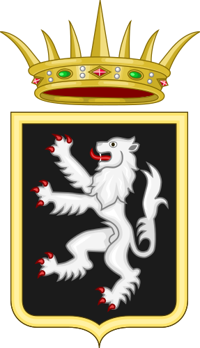
Italiano: stemma della provincia di Aosta
English: coat of arms of the Aosta Province Français : blason de la province d'Aoste |
||
| Data | |||
| Font | Treball propi | ||
| Autor | F l a n k e r | ||
| Permís (Com reutilitzar aquest fitxer) |
Jo, el titular dels drets d'autor d'aquest treball, el public sota les següents llicències:
Aquest fitxer està subjecte a la llicència Creative Commons Reconeixement i Compartir Igual 3.0 No adaptada, 2.5 Genèrica, 2.0 Genèrica i 1.0 Genèrica.
Podeu seleccionar la llicència que vulgueu. |
||
| Altres versions |
|


Historial del fitxer
Cliqueu una data/hora per veure el fitxer tal com era aleshores.
| Data/hora | Miniatura | Dimensions | Usuari/a | Comentari | |
|---|---|---|---|---|---|
| actual | 19:41, 26 jul 2022 | | 287 × 500 (577 Ko) | MostEpic (discussió | contribucions) | minor changes |
| 11:55, 26 jul 2022 |  | 512 × 882 (62 Ko) | Ketipmaig (discussió | contribucions) | stemma ufficiale. quello precedente era il logo regionale non lo stemma. fonte; https://www.regione.vda.it/autonomia_istituzioni/Simboli_Regione/stemma_e_gonfalone/stemma_gonfalone_i.aspx. lo stemma è basato su: https://www.regione.vda.it/allegato.aspx?pk=33269 | |
| 10:04, 19 nov 2021 |  | 225 × 333 (38 Ko) | Facquis (discussió | contribucions) | Correct CoA https://www.regione.vda.it/immagine.aspx?pk=44714 | |
| 12:46, 16 jul 2010 |  | 185 × 300 (26 Ko) | GJo (discussió | contribucions) | CoA correct, see: http://www.araldicacivica.it/pix/intro/regioni/valle%20d%27aosta.jpg | |
| 05:01, 28 set 2009 |  | 681 × 872 (87 Ko) | Ssire (discussió | contribucions) | plus leger | |
| 22:58, 27 set 2009 |  | 601 × 870 (141 Ko) | Ssire (discussió | contribucions) | armé lampassé de gueules ! | |
| 10:07, 13 gen 2007 |  | 185 × 300 (23 Ko) | F l a n k e r (discussió | contribucions) | {{Information |Description={{it|stemma della provincia di Aosta}} {{en|coat of arms of the Aosta Province}} |Source= |Date=13 Jan. 2006 |Author=F l a n k e r |Permission={{PD-self}} |other_versions= }} [[Category:Coats of arms of p | |
| 10:02, 13 gen 2007 |  | 185 × 300 (23 Ko) | F l a n k e r (discussió | contribucions) | {{Information |Description={{it|stemma della provincia di Aosta}} {{en|coat of arms of the Aosta Province}} |Source= |Date=13 Jan. 2006 |Author=F l a n k e r |Permission={{PD-self}} |other_versions= }} [[Category:Coats of arms of p |
No podeu sobreescriure aquest fitxer.
Ús del fitxer
Les 21 pàgines següents utilitzen aquest fitxer:
- Coats of arms of the Aosta Valley
- Valle d'Aosta - Vallée d'Aoste
- User:Argean/Flags of Europe
- User:Argean/sandbox
- User:MostEpic
- Commons:Files used on the OpenStreetMap Wiki/28
- Category:2013 in Aosta Valley
- Category:Aosta Valley
- Category:Births in Aosta Valley
- Category:Births in Aosta Valley by city
- Category:Bridges in Aosta Valley
- Category:Category navigational templates for Aosta Valley
- Category:Deaths in Aosta Valley
- Category:Languages of Aosta Valley
- Category:Maps of Aosta Valley
- Category:Presidents of Aosta Valley
- Category:Rail transport in Aosta Valley
- Category:Railway lines in Aosta Valley
- Category:Rivers of Aosta Valley
- Category:Ruins in Aosta Valley
- Category:Views of Aosta Valley
Ús global del fitxer
Utilització d'aquest fitxer en altres wikis:
- Utilització a als.wikipedia.org
- Unité des communes valdôtaines Walser
- Aostatal
- Allein (Aostatal)
- Antey-Saint-André
- Aosta
- Arnad
- Arvier
- Avise
- Ayas (Aostatal)
- Aymavilles
- Bard (Aostatal)
- Bionaz
- Brissogne
- Brusson (Aostatal)
- Challand-Saint-Anselme
- Challand-Saint-Victor
- Chambave
- Chamois (Aostatal)
- Champdepraz
- Champorcher
- Charvensod
- Châtillon (Aostatal)
- Cogne
- Courmayeur
- Donnas
- Doues
- Emarèse
- Étroubles
- Fénis
- Fontainemore
- Gignod
- Gressan
- Hône
- Introd
- Issogne
- Jovençan
- La Magdeleine (Aostatal)
- La Salle (Aostatal)
- La Thuile (Aostatal)
- Lillianes
- Montjovet
- Morgex
- Nus
- Ollomont
- Oyace
- Perloz
- Pollein
- Pontboset
- Pontey
- Pont-Saint-Martin (Aostatal)
Vegeu més usos globals d'aquest fitxer.