File:Varendorf(62)Altona Hamburg Harburg.jpg
Spring til navigation
Spring til søgning
Størrelse af denne forhåndsvisning: 593 × 599 pixels. Andre opløsninger: 238 × 240 pixels | 475 × 480 pixels | 760 × 768 pixels | 1.013 × 1.024 pixels | 2.027 × 2.048 pixels | 3.565 × 3.602 pixels.
Oprindelig fil (3.565 × 3.602 billedpunkter, filstørrelse: 15,77 MB, MIME-type: image/jpeg)
Captions
Captions
Tilføj en kort forklaring på en enkelt linje om hvad filen viser
|
Værket er også offentlig ejendom i lande og områder, hvor ophavsrettens længde er ophavsmandens levetid plus 100 år eller derunder. | |
| Denne fil er blevet identificeret som værende fri for kendte restriktioner under lov om ophavsret, herunder alle relaterede og tilstødende rettigheder. | |
Filhistorik
Klik på en dato/tid for at se filen som den så ud på det tidspunkt.
| Dato/tid | Miniaturebillede | Dimensioner | Bruger | Kommentar | |
|---|---|---|---|---|---|
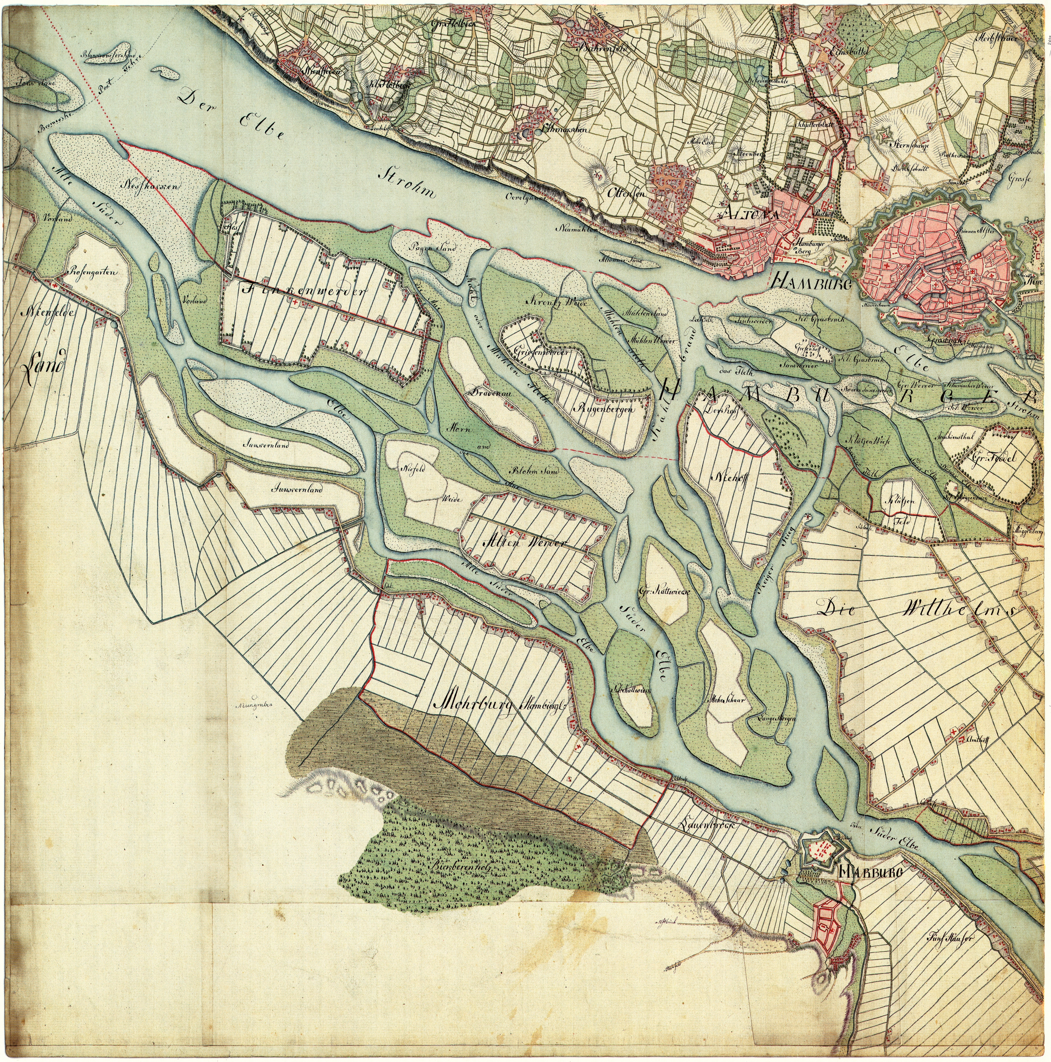
| nuværende | 6. nov. 2008, 13:28 | | 3.565 × 3.602 (15,77 MB) | Jom (diskussion | bidrag) | {{Information |Description=Altona, Hamburg, Harburg. Aufgenommen in den Jahren 1789 bis 1796 unter der Direktion des Majors Gustav Adolf von Varendorf durch Offiziere des Schleswigschen Infanterieregiments |Source=Gustav Adolf von Varendorf |Date=1789 - 1 |
Du kan ikke overskrive denne fil.
Filanvendelse
De følgende 9 sider bruger denne fil:
- User:Jom/Maps
- File:Grasbrook johnsche ecke.jpg
- File:Karte harvestehude vahrendorf.jpg
- File:Kartenausschnitt Altona Hamburg 1789.PNG
- File:Reiherstieg-vor-1800.jpg
- File:Schulterblatt um 1790.jpg
- File:Sternschanze aus varendorf(62)Altona Hamburg Harburg.png
- File:Tollerort-map-varendorf.jpg
- File:Wallanlagen varendorf(62)Altona Hamburg Harburg.png
Altona_Hamburg_Harburg.png)
Altona_Hamburg_Harburg.png)
Global filanvendelse
Følgende andre wikier anvender denne fil:
- Anvendelser på ca.wikipedia.org
- Anvendelser på de.wikipedia.org
- Anvendelser på es.wikipedia.org
- Anvendelser på nds.wikipedia.org
Metadata
Altona_Hamburg_Harburg.jpg&oldid=728755966)
Kategorier:
- Maps by Gustav Adolf von Varendorf
- Parts of old maps of Hamburg
- Maps of Hamburg-Altenwerder
- Maps of Hamburg-Altona-Altstadt
- Maps of Hamburg-Altona-Nord
- Maps of Hamburg-Altstadt
- Maps of Hamburg-Bahrenfeld
- Maps of Hamburg-Eimsbüttel
- Maps of Hamburg-Finkenwerder
- Maps of Hamburg-Groß Flottbek
- Maps of Hamburg-HafenCity
- Maps of Hamburg-Harburg
- Maps of Hamburg-Harvestehude
- Maps of Hamburg-Kleiner Grasbrook
- Maps of Hamburg-Moorburg
- Maps of Hamburg-Neuenfelde
- Maps of Hamburg-Neustadt
- Maps of Hamburg-Nienstedten
- Maps of Hamburg-Othmarschen
- Maps of Hamburg-Ottensen
- Maps of Hamburg-Rotherbaum
- Maps of Hamburg-Sternschanze
- Maps of Hamburg-St. Pauli
- Maps of Hamburg-Veddel
- Maps of Hamburg-Wilhelmsburg
- Maps of Elbe in Hamburg
- Köhlbrand
- Norderelbe
- Süderelbe
- Naturschutzgebiet Finkenwerder Süderelbe
- Reiherstieg
- Rethe
- Hamburger Stromspaltungsgebiet
- 1790s maps of Hamburg