File:Venezuela Division Politica Territorial.svg
ナビゲーションに移動
検索に移動

この SVG ファイルのこの PNG プレビューのサイズ: 781 × 600 ピクセル. その他の解像度: 313 × 240 ピクセル | 625 × 480 ピクセル | 1,000 × 768 ピクセル | 1,280 × 983 ピクセル | 2,560 × 1,966 ピクセル | 2,121 × 1,629 ピクセル。
元のファイル (SVG ファイル、2,121 × 1,629 ピクセル、ファイルサイズ: 141キロバイト)
キャプション
キャプション
このファイルの内容を1行で記述してください
| 解説 |
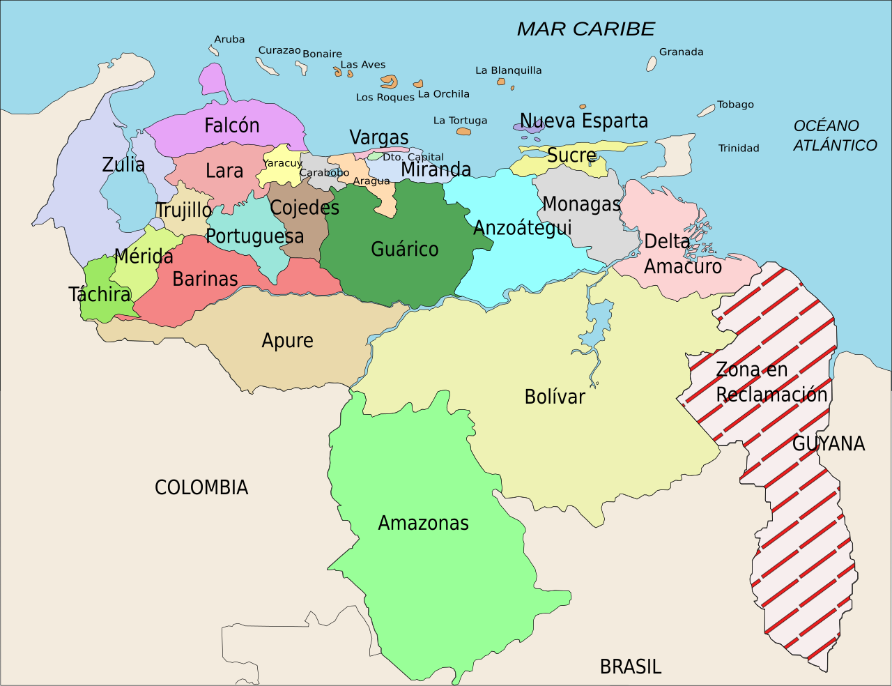
Español: División Político Territorial de Venezuela. Es un mapa acerca de los estados de Venezuela o división político territorial. La zona en reclamación aun no se sabe si pertenece a Guyana o a Venezuela, por eso se suele colocar de esa manera.
English: Political divisions of Venezuela. The Reclamation zone is Guyanan territory claimed by Venezuela. |
| 日付 | |
| 原典 | self work, Image:Venezuela politica copy.png based |
| 作者 | Wilfredor |
| 許可 (ファイルの再利用) |
Own work, copyleft: Multi-license with GFDL and Creative Commons CC-BY-SA-2.5 and older versions (2.0 and 1.0) |
| その他のバージョン |
このファイルの派生的著作物: Venezuela Division Politica Territorial mk.svg
[]
|


この作品の著作権者である私は、この作品を以下のライセンスで提供します。

|
この文書は、フリーソフトウェア財団発行のGNUフリー文書利用許諾書 (GNU Free Documentation License) 1.2またはそれ以降のバージョンの規約に基づき、複製や再配布、改変が許可されます。不可変更部分、表紙、背表紙はありません。このライセンスの複製は、GNUフリー文書利用許諾書という章に含まれています。 |
| このファイルはクリエイティブ・コモンズ 表示-継承 3.0 非移植ライセンスのもとに利用を許諾されています。 | ||
| ||
| このライセンスのテンプレートは、GFDLのライセンス・アップデートによりこのファイルに追加されたものです。 |
- あなたは以下の条件に従う場合に限り、自由に
- 共有 – 本作品を複製、頒布、展示、実演できます。
- 再構成 – 二次的著作物を作成できます。
- あなたの従うべき条件は以下の通りです。
- 表示 – あなたは適切なクレジットを表示し、ライセンスへのリンクを提供し、変更があったらその旨を示さなければなりません。これらは合理的であればどのような方法で行っても構いませんが、許諾者があなたやあなたの利用行為を支持していると示唆するような方法は除きます。
- 継承 – もしあなたがこの作品をリミックスしたり、改変したり、加工した場合には、あなたはあなたの貢献部分を元の作品とこれと同一または互換性があるライセンスの下に頒布しなければなりません。
あなたは上記のライセンスから、どれか一つ以上を選択できます。
ファイルの履歴
過去の版のファイルを表示するには、その版の日時をクリックしてください。
| 日付と時刻 | サムネイル | 寸法 | 利用者 | コメント | |
|---|---|---|---|---|---|
| 現在の版 | 2008年4月16日 (水) 21:00 | | 2,121 × 1,629 (141キロバイト) | Wilfredor (トーク | 投稿記録) | {{Information |Description= '''(Spanish):''' División Político Territorial de Venezuela. Es un mapa acerca de los estados de Venezuela o división político territorial. La zona en reclamación aun no se sabe si pertenece a Guyana o a Venezuela, por es |
| 2007年4月21日 (土) 15:17 |  | 2,121 × 1,629 (140キロバイト) | Wilfredor (トーク | 投稿記録) | {{Information |Description= '''(Spanish):''' División Político Territorial de Venezuela. Es un mapa acerca de los estados de Venezuela o división político territorial. La zona en reclamación aun no se sabe si pertenece a Guyana o a Venezuela, por es | |
| 2007年4月19日 (木) 21:11 |  | 2,121 × 1,629 (135キロバイト) | Spundun (トーク | 投稿記録) | Reverted to earlier revision | |
| 2007年4月19日 (木) 21:10 |  | 2,119 × 1,629 (135キロバイト) | Spundun (トーク | 投稿記録) | Reverted to earlier revision | |
| 2007年4月19日 (木) 14:52 |  | 2,121 × 1,629 (135キロバイト) | Wilfredor (トーク | 投稿記録) | {{Information |Description= '''(Spanish):''' División Político Territorial de Venezuela </br> '''(English):''' Politic Territorial Division of Venezuela |Source=self work, Image:Venezuela politica copy.png based |Date=2007 |Author=[[user:wilfredo | |
| 2007年4月18日 (水) 00:33 |  | 2,119 × 1,629 (135キロバイト) | Wilfredor (トーク | 投稿記録) | {{Information |Description= '''(Spanish):''' División Político Territorial de Venezuela </br> '''(English):''' Politic Territorial Division of Venezuela |Source=self work |Date=2007 |Author=Wilfredo R. Rodriguez H. |Permission=Own wo | |
| 2007年4月17日 (火) 23:55 |  | 2,119 × 1,629 (124キロバイト) | Wilfredor (トーク | 投稿記録) | {{Information |Description= '''(Spanish):''' División Político Territorial de Venezuela </br> '''(English):''' Politic Territorial Division of Venezuela |Source=self work |Date=2007 |Author=Wilfredo R. Rodriguez H. |Permission=Own wo | |
| 2007年4月17日 (火) 20:56 |  | 2,160 × 1,664 (107キロバイト) | Wilfredor (トーク | 投稿記録) | {{Information |Description= '''(Spanish):''' División Político Territorial de Venezuela </br> '''(English):''' Politic Territorial Division of Venezuela |Source=self work |Date=2007 |Author=Wilfredo R. Rodriguez H. |Permission=Own wo | |
| 2007年4月17日 (火) 13:30 |  | 2,160 × 1,664 (88キロバイト) | Wilfredor (トーク | 投稿記録) | {{Information |Description= '''(Spanish):''' División Político Territorial de Venezuela </br> '''(English):''' Politic Territorial Division of Venezuela |Source=self work |Date=2007 |Author=Wilfredo R. Rodriguez H. |Permission=Own wo | |
| 2007年4月17日 (火) 02:54 |  | 2,160 × 1,664 (83キロバイト) | Wilfredor (トーク | 投稿記録) | {{Information |Description= '''(Spanish):''' División Político Territorial de Venezuela </br> '''(English):''' Politic Territorial Division of Venezuela |Source=self work |Date=2007 |Author=Wilfredo R. Rodriguez H. |Permission=Own wo |
このファイルは上書きできません。
ファイルの使用状況
以下の 10 ページがこのファイルを使用しています:
- Atlas of Venezuela
- Commons:Featured picture candidates/Image:Venezuela Division Politica Territorial.svg
- Commons:Featured picture candidates/Log/April 2007
- Commons:Quality images candidates/Archives April 2007
- File:Venezuela Division Politica Territorial.svg
- File:Venezuela Division Politica Territorial ka.svg
- File:Venezuela Division Politica Territorial mk.svg
- File:Venezuela politica copy.png
- Template:Other versions/Venezuela Division Politica Territorial
- Category:Relations of Guyana and Venezuela
グローバルなファイル使用状況
以下に挙げる他のウィキがこの画像を使っています:
- an.wikipedia.org での使用状況
- be.wikipedia.org での使用状況
- br.wikipedia.org での使用状況
- bs.wikipedia.org での使用状況
- cs.wikipedia.org での使用状況
- da.wikipedia.org での使用状況
- de.wikipedia.org での使用状況
- en.wikipedia.org での使用状況
- es.wikipedia.org での使用状況
- Categoría:Estados de Venezuela
- Wikiproyecto Discusión:Venezuela/1
- Categoría:Municipios de Venezuela
- Usuario:Dezulovic
- Anexo:Gobernadores de Venezuela
- Agua potable y saneamiento en Venezuela
- Categoría:Geografía de Venezuela por estado
- Categoría:Localidades de Venezuela por estado
- Wikiproyecto:Relaciones bilaterales/creados
- es.wikibooks.org での使用状況
- es.wikinews.org での使用状況
- fiu-vro.wikipedia.org での使用状況
- fi.wikipedia.org での使用状況
- frr.wikipedia.org での使用状況
- fr.wikipedia.org での使用状況
- Projet:Géographie/Palettes de navigation
- Modèle:Palette États du Venezuela
- États du Venezuela
- État de Bolívar
- État de La Guaira
- État de Táchira
- État de Lara
- État de Falcón
- État d'Yaracuy
- État de Carabobo
- État de Zulia
- État de Portuguesa
- État de Trujillo
- État de Cojedes
- État d'Aragua
- État d'Amazonas (Venezuela)
- État de Guárico
- État de Barinas
このファイルのグローバル使用状況を表示する。