File:Venlo. Blerick met oeververbinding over de Maas, 1843.jpg
Jump to navigation
Jump to search

Size of this preview: 800 × 470 pixels. Other resolutions: 320 × 188 pixels | 640 × 376 pixels | 1,024 × 601 pixels | 1,604 × 942 pixels.
Original file (1,604 × 942 pixels, file size: 598 KB, MIME type: image/jpeg)
Captions
Captions
Add a one-line explanation of what this file represents
Summary
[edit]| Description |
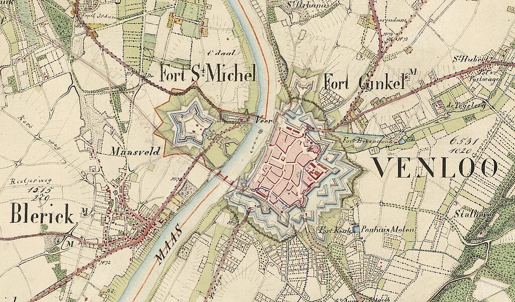
Nederlands: Venlo. Blerick met gepland spoortraject en een oeververbinding over de Maas, 1843. De eerste spoorbrug aldaar werd gerealiseerd in 1865 (zie ook hier). Het geplande spoortraject is er mogelijk later ingetekend. |
| Date | |
| Source | |
| Author | W. de Petit |

Licensing
[edit]
| This file is made available under the Creative Commons CC0 1.0 Universal Public Domain Dedication. | |
| The person who associated a work with this deed has dedicated the work to the public domain by waiving all of their rights to the work worldwide under copyright law, including all related and neighboring rights, to the extent allowed by law. You can copy, modify, distribute and perform the work, even for commercial purposes, all without asking permission.
|
File history
Click on a date/time to view the file as it appeared at that time.
| Date/Time | Thumbnail | Dimensions | User | Comment | |
|---|---|---|---|---|---|
| current | 19:13, 19 November 2023 | | 1,604 × 942 (598 KB) | Mdd (talk | contribs) | Uploaded a work by W. de Petit from {{Extracted from|File:Overzicht Venlo met omliggende dorpen.jpg}} with UploadWizard |
You cannot overwrite this file.
File usage on Commons
The following 2 pages use this file:
File usage on other wikis
The following other wikis use this file:
- Usage on www.wikidata.org
Metadata
Categories:
- Old maps of Venlo
- History of Blerick
- Fortifications of Venlo
- Fort Sint-Michiel
- Fort Ginkel (Venlo)
- Fort Beerendonck (Venlo)
- Bastion Keulen (Venlo)
- Geldersepoort, Venlo (city gate)
- Bouw van spoorbrug Venlo, 1861-1865
- Oude Maasbrug te Venlo
- De Weerd (Venlo)
- Helbeek (beek in Venlo)
- Grand Canal du Nord in Venlo
- Rijnbeek (Venlo) on old maps
- Hoogmolenbeek (Venlo)
- Panhuismolen
- Herungerweg (Venlo)
- Gelderse Postwagen
- Herungerstraat (Venlo)
- De Tichelarij (farm)
- Cedronsbeek (Venlo)
- Broesert (Venlo)
- Provinciale weg 273