File:Venus Aine Corona.jpg

Alkuperäinen tiedosto (1 000 × 784 kuvapistettä, 401 KiB, MIME-tyyppi: image/jpeg)
Kuvatekstit
Kuvatekstit
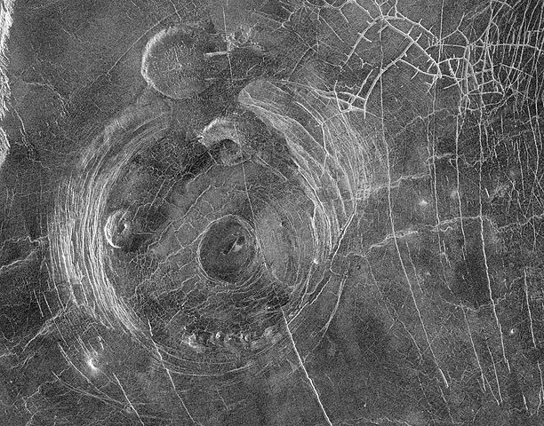
Original Caption Released with Image:
This Magellan radar image shows a region approximately 300 kilometers (180 miles) across, centered on 59 degrees south latitude, 164 degrees east longitude and located in a vast plain to the south of Aphrodite Terra. The data for this image was obtained in January 1991. The large circular structure near the center of the image is a corona, approximately 200 kilometers (120 miles) in diameter and provisionally named Aine Corona. Just north of Aine Corona is one of the flat-topped volcanic constructs known as 'pancake' domes for their shape and flap-jack appearance. This pancake dome is about 35 kilometers (21 miles) in diameter and is thought to have formed by the eruption of an extremely viscous lava. Another pancake dome is located inside the western parts of the annulus of the corona fractures. Complex fracture patterns like the one in the upper right of the image are often observed in association with coronae and various volcanic features. They are thought to form because magma beneath the surface follows pre-existing fracture patterns. When eruptions or other movements of the magma occur, the magma drains from the fractures and the overlying surface rock collapses. Other volcanic features associated with Aine Corona include a set of small domes, each less than 10 kilometers (6 miles) across, located along the southern portion of the annulus of fractures, and a smooth, flat region in the center of the corona, probably a relatively young lava flow. The range of volcanic features associated with coronae suggests that volcanism plays a significant role in their formation.
Image Note: F-MIDR 59S164
Source: http://photojournal.jpl.nasa.gov/catalog/PIA00202
This image or video was catalogued by Jet Propulsion Laboratory of the United States National Aeronautics and Space Administration (NASA) under Photo ID: PIA00202. This tag does not indicate the copyright status of the attached work. A normal copyright tag is still required. See Commons:Licensing. Other languages:
|
| Tämä teos on ilman tekijänoikeuden suojaa, koska National Aeronautics and Space Administration (NASA) loi sen. Koska Nasa on Yhdysvaltain liittovaltion organisaatio, sen luomat teokset ovat ilman tekijänoikeuden suojaa. ([1][2]) | ||
 |
Varoitukset:
|
Tiedoston historia
Päiväystä napsauttamalla näet, millainen tiedosto oli kyseisellä hetkellä.
| Päiväys | Pienoiskuva | Koko | Käyttäjä | Kommentti | |
|---|---|---|---|---|---|
| nykyinen | 6. elokuuta 2005 kello 10.47 | | 1 000 × 784 (401 KiB) | Vzb83~commonswiki (keskustelu | muokkaukset) | '''Original Caption Released with Image:''' This Magellan radar image shows a region approximately 300 kilometers (180 miles) across, centered on 59 degrees south latitude, 164 degrees east longitude and located in a vast plain to the south of Aphrodite |
Et voi tallentaa uutta tiedostoa tämän tilalle.
Tiedoston käyttö
Seuraava sivu käyttää tätä tiedostoa:
Tiedoston järjestelmänlaajuinen käyttö
Seuraavat muut wikit käyttävät tätä tiedostoa:
- Käyttö kohteessa fi.wikipedia.org