File:Veselý Kopec, CZ171201-125.jpg
Jump to navigation
Jump to search

Size of this preview: 800 × 463 pixels. Other resolutions: 320 × 185 pixels | 640 × 371 pixels | 1,024 × 593 pixels | 1,280 × 741 pixels | 2,560 × 1,482 pixels | 4,744 × 2,747 pixels.
Original file (4,744 × 2,747 pixels, file size: 4.72 MB, MIME type: image/jpeg)
Captions
Captions
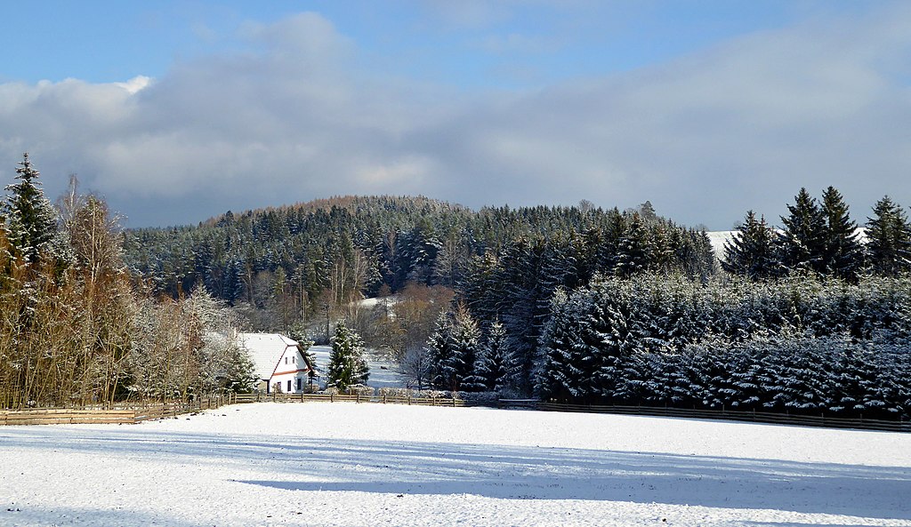
Landscape of the Iron Mountains.
Summary
[edit]
| Description |
English: The landscape of the Iron Mountains, a winter under Veselý Kopec (borderline of geomorphological districts Kameničská vrchovina and Stružinecká pahorkatina). Veselý Kopec is locality of small hamlet on the part of the cadastral territory Dřevíkov, with the range 535-579 m above sea level on the eastern to southeast slope of the hill Na Veselém Kopci (579 m). It lies above the left bank of the river Chrudimka, in the geomorphological district with name Stružinecká knoll land. Trough of meandering river forms the boundary between geomorphological districts. Forested slopes above the right bank of the river belongs to the Kameničská Highlands, in terms of orography the highest landscape area in the Iron Mountains. In the part of small hamlet Veselý Kopec is a exposition of folk architecture and technicals buildings with name Open air Museum Vysočina (formerly named Set of Folk Buildings Vysočina). Photo-location: Czechia, Pardubice Region, village Vysočina, Veselý Kopec – small hamlet and exposition of Open air Museum Vysočina (formerly named Set of Folk Buildings Vysočina).
Čeština: Krajina Železných hor, zima pod Veselým Kopcem (rozhraní geomorfologických okrsků Kameničská vrchovina a Stružinecká pahorkatina). Veselý Kopec je sídelní lokalitou typu vesničky na části katastrálního území Dřevíkov, s rozsahem 535–579 m n. m. na východním až jihovýchodním svahu vyvýšeniny s vrcholem Na Veselém Kopci (579 m). Veselý Kopec leží nad levým břehem řeky Chrudimky, v geomorfologickém okrsku Stružinecká pahorkatina. Koryto meandrující řeky tvoří hranici mezi geomorfologickými okrsky. Zalesněné svahy nad pravým břehem řeky náleží do Kameničské vrchoviny, z hlediska horopisu je to nejvyšší krajinná oblast v Železných horách. V části malé vesnice expozice lidové architektury a technického stavitelství v Muzeu v přírodě Vysočina (dříve Soubor lidových staveb Vysočina), lidově nazývaná skanzen. Foto-lokace: Česko, Pardubický kraj, obec Vysočina, Veselý Kopec – vesnička a expozice Muzea v přírodě Vysočina (dříve název Soubor lidových staveb Vysočina). |
| Date | |
| Source | Own work |
| Author | Josef Kreuz (PEPan) |
| Camera location | | View this and other nearby images on: OpenStreetMap |
|---|
Externí odkazy
[edit]
- Veselý Kopec a okolí – turistická mapa, letecký pohled viz
- Stružinecká pahorkatina, geomorfologický okrsek – heslo CS Wikipedie viz
Licensing
[edit]
I, the copyright holder of this work, hereby publish it under the following license:
This file is licensed under the Creative Commons Attribution-Share Alike 4.0 International license.
- You are free:
- to share – to copy, distribute and transmit the work
- to remix – to adapt the work
- Under the following conditions:
- attribution – You must give appropriate credit, provide a link to the license, and indicate if changes were made. You may do so in any reasonable manner, but not in any way that suggests the licensor endorses you or your use.
- share alike – If you remix, transform, or build upon the material, you must distribute your contributions under the same or compatible license as the original.
File history
Click on a date/time to view the file as it appeared at that time.
| Date/Time | Thumbnail | Dimensions | User | Comment | |
|---|---|---|---|---|---|
| current | 14:21, 6 December 2017 | | 4,744 × 2,747 (4.72 MB) | PEPan (talk | contribs) | User created page with UploadWizard |
You cannot overwrite this file.
File usage on Commons
There are no pages that use this file.
File usage on other wikis
The following other wikis use this file:
- Usage on cs.wikipedia.org