File:Vespacians Camp Wiltshire.jpg
Jump to navigation
Jump to search

Size of this preview: 800 × 513 pixels. Other resolutions: 320 × 205 pixels | 640 × 410 pixels | 911 × 584 pixels.
Original file (911 × 584 pixels, file size: 134 KB, MIME type: image/jpeg)
Captions
Captions
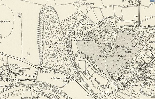
Amesbury Park, Abbey, and Church and Environs Map, circa 1901
Summary
[edit]
| Description |
English: Section of the six inches to the mile OS map of Wiltshire, England published in 1901. It shows the location of Vespacians Camp Iron Age hill fort in relation to West Amesbury, Amesbury Abbey and the modern town of Amesbury. |
| Date | |
| Source | National Library Of Scotland map archive |
| Author | Ordnance Survey 1901 |
Licensing
[edit]
|
This work is in the public domain in its country of origin and other countries and areas where the copyright term is the author's life plus 70 years or fewer. This work is in the public domain in the United States because it was published (or registered with the U.S. Copyright Office) before January 1, 1929. | |
| This file has been identified as being free of known restrictions under copyright law, including all related and neighboring rights. | |
File history
Click on a date/time to view the file as it appeared at that time.
| Date/Time | Thumbnail | Dimensions | User | Comment | |
|---|---|---|---|---|---|
| current | 18:09, 15 January 2017 | | 911 × 584 (134 KB) | Lumos3 (talk | contribs) | User created page with UploadWizard |
You cannot overwrite this file.
File usage on Commons
There are no pages that use this file.
File usage on other wikis
The following other wikis use this file:
- Usage on en.wikipedia.org
- Usage on es.wikipedia.org