File:Vexilographic maps of Pontic littoral by end of 13th-17th century.svg
Перейти к навигации
Перейти к поиску

Размер этого PNG-превью для исходного SVG-файла: 800 × 437 пкс. Другие разрешения: 320 × 175 пкс | 640 × 349 пкс | 1024 × 559 пкс | 1280 × 699 пкс | 2560 × 1397 пкс | 1640 × 895 пкс.
Исходный файл (SVG-файл, номинально 1640 × 895 пкс, размер файла: 2,58 Мб)
Краткие подписи
Краткие подписи
Добавьте однострочное описание того, что собой представляет этот файл
Краткое описание[править]
| Описание |
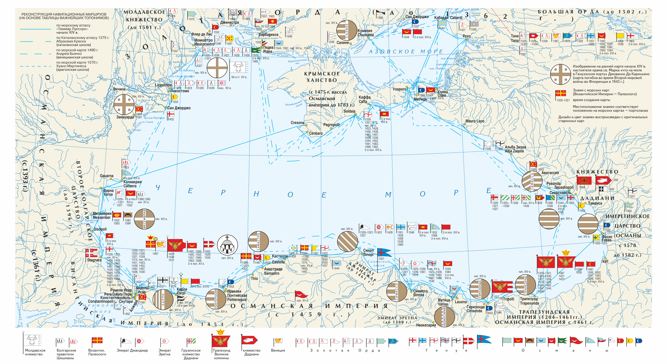
Русский: Векселлографическая карта-реконструкция Причерноморского региона «Флаги Причерноморских городов и государств по средневековым морским картам конца XIII — XVII вв.»
English: Vexilographic maps of Pontic littoral by the End of the 13th — the 17th Centuries. Territories and rulers (flags from right to left):
Key
|
| Дата | |
| Источник | Издание: Карпов С.П. История Трапезундской империи. СПб. 2007. (между стр. 32—33; 0,5 п. л.). |
| Автор | Игорь Константинович Фоменко |
| Права (Повторное использование этого файла) |
Лицензирование[править]
Этот файл доступен по лицензии Creative Commons Attribution-Share Alike 3.0 Unported.
- Вы можете свободно:
- делиться произведением – копировать, распространять и передавать данное произведение
- создавать производные – переделывать данное произведение
- При соблюдении следующих условий:
- атрибуция – Вы должны указать авторство, предоставить ссылку на лицензию и указать, внёс ли автор какие-либо изменения. Это можно сделать любым разумным способом, но не создавая впечатление, что лицензиат поддерживает вас или использование вами данного произведения.
- распространение на тех же условиях – Если вы изменяете, преобразуете или создаёте иное произведение на основе данного, то обязаны использовать лицензию исходного произведения или лицензию, совместимую с исходной.
История файла
Нажмите на дату/время, чтобы увидеть версию файла от того времени.
| Дата/время | Миниатюра | Размеры | Участник | Примечание | |
|---|---|---|---|---|---|
| текущий | 16:47, 28 марта 2019 | | 1640 × 895 (2,58 Мб) | Niklitov (обсуждение | вклад) | User created page with UploadWizard |
Вы не можете перезаписать этот файл.
Использование файла
Следующие 7 страниц используют этот файл:
- Atlas
- User:J budissin/Uploads/BiH/2019 March 21-31
- Commons:Featured picture candidates/File:Vexilographic maps of Pontic littoral by end of 13th-17th century.svg
- Commons:Featured picture candidates/Log/April 2019
- File:Candaroğlu according to the Catalan Atlas c.1375.jpg
- File:Dadiani flag 1358.svg
- File:Flag of Semiso in Catalan atlas.svg
Глобальное использование файла
Данный файл используется в следующих вики:
- Использование в en.wikipedia.org
- Использование в it.wikipedia.org
- Использование в lij.wikipedia.org
- Использование в ru.wikipedia.org
- Использование в ru.wikimedia.org
Метаданные
Категории:
- Maps of the Black Sea
- SVG maps of Eurasia
- Maps showing 13th-century history
- Maps showing 14th-century history
- Maps showing 15th-century history
- Maps showing 16th-century history
- Maps showing 17th-century history
- Maps of Old Great Bulgaria
- Maps of the Principality of Moldavia
- Maps of the Byzantine Empire
- Maps of the Empire of Trebizond
- Dadiani
- SVG vexilographic maps
- Isfendiyarids
- SVG historical flags
- Heraldic flags
- Maps by Igor Fomenko
- Maps of the history of Greece
- Maps of the Ottoman Empire
- Maps of the Golden Horde
- Maps of the history of the Caucasus
- SVG maps of the history of Russia
- Maps of the history of Moldova
- English-language maps of Europe
- Russian-language maps of Europe
- 21st-century maps of the Black Sea