File:Vicente 2005-09-16 0550Z.jpg
跳转到导航
跳转到搜索

本预览的尺寸:480 × 600像素。 其他分辨率:192 × 240像素 | 384 × 480像素 | 614 × 768像素 | 819 × 1,024像素 | 1,638 × 2,048像素 | 6,400 × 8,000像素。
原始文件 (6,400 × 8,000像素,文件大小:6.8 MB,MIME类型:image/jpeg)
说明
说明
添加一行文字以描述该文件所表现的内容
摘要
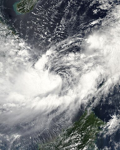
[编辑]| 描述 | This image of Tropical Storm Vicente was captured by the MODIS instrument on NASA's Aqua satellite at 0546 UTC when it was located in the South China Sea. The maximum sustained winds for the storm were 30 knots (10-minute average) and the minimum pressure was about 1000 mb. | ||||||
| 日期 | |||||||
| 来源 | http://www.nrlmry.navy.mil/tc_pages/tc_home.html | ||||||
| 作者 | Naval Research Laboratory | ||||||
| 授权 (二次使用本文件) |
|
||||||

文件历史
点击某个日期/时间查看对应时刻的文件。
| 日期/时间 | 缩略图 | 大小 | 用户 | 备注 | |
|---|---|---|---|---|---|
| 当前 | 2020年9月29日 (二) 15:55 | | 6,400 × 8,000(6.8 MB) | FleurDeOdile(留言 | 贡献) | dimensions |
| 2017年12月13日 (三) 04:26 |  | 6,706 × 6,562(3.98 MB) | TheAustinMan(留言 | 贡献) | Color and grid-less | |
| 2006年9月14日 (四) 16:56 |  | 3,875 × 3,875(1.63 MB) | Good kitty(留言 | 贡献) | == Summary == {{Information |Description=This image of Tropical Storm Vicente was captured by the MODIS instrument on NASA's Aqua satellite at 0546 UTC when it was located in the South China Sea. The maximum sustained winds for the storm were 30 knots (10 |
您不可以覆盖此文件。
文件用途
以下2个页面使用本文件:
全域文件用途
以下其他wiki使用此文件:
- en.wikipedia.org上的用途
- es.wikipedia.org上的用途
- ja.wikipedia.org上的用途
- ko.wikipedia.org上的用途
- pt.wikipedia.org上的用途
- vi.wikipedia.org上的用途
- zh.wikipedia.org上的用途