File:View from Mangart MC cropped.jpg
Jump to navigation
Jump to search
Size of this preview: 800 × 407 pixels. Other resolutions: 320 × 163 pixels | 640 × 325 pixels | 1,024 × 521 pixels | 1,280 × 651 pixels | 2,560 × 1,301 pixels | 4,149 × 2,109 pixels.
Original file (4,149 × 2,109 pixels, file size: 4.25 MB, MIME type: image/jpeg)
Captions
Captions
Add a one-line explanation of what this file represents
Summary[edit]
| Description |
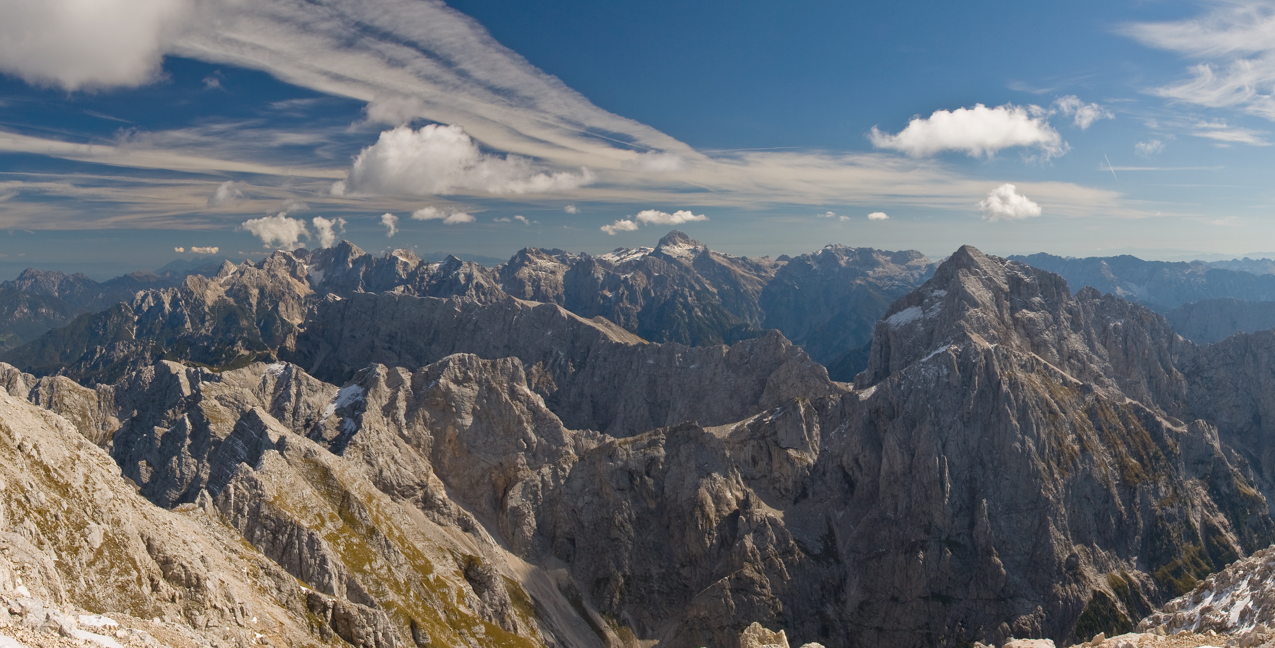
Čeština: Pohled z vrcholu Mangartu (2679m) ve směru Triglavského národního parku. Uprostřed vzadu je vrchol Triglavu (2864m), nejvyšší hory Slovinska. Panoráma je sestavené ze tří fotografií za pomoci PTGUI [1]. Deutsch: Blick vom Gipfel des Mangart (2679m) in Richtung des Triglav Nationalparks. Der Gipfel des Triglav (2864m), der höchste Berg in Slowenien ist in der Mitte des Bildes im Hintergrund erkennbar. Panorama zusammengesetzt aus drei Querformatbildern mittels PTGUI [2]. English: View from top of the Mangart (2679m) to Triglav National Park. Triglav (2864m), the highest mountain in Slovenia is seen in the background in the middle of the image. Panorama stitched from three landscape format images using PTGUI [3]. Français : Vue depuis le sommet du mont Mangart (2679m) sur le parc national du Triglav. Le sommet du Triglav, point culminant de la Slovénie, est visible au fond et au centre de l'image. Image panoramique obtenue en assemblant trois clichés avec PTGUI [4]. Русский: Вид с вершины горы Мангарт (2679м) на национальный парк Триглав. Вершина Триглава (2864м), высочайшей вершины Словении, находится по центру заднего плана. Панорама составлена из трёх фотографий с использованием PTGUI [5]. Slovenščina: Pogled z Mangrta proti vzhodu (od leve proti desni so vidni Ponca, Špikova skupina, Mojstrovka, Škrlatica, Razor, Prisank, Travnik, Triglav, Kanjavec, Jalovec (v ospredju), Lepo špičje, ... Українська: Вид з вершини гори Мангарт (2679м) на Національний Парк Триглав. Вершина Триглава (2864м), найвищої вершини Словенії, знаходиться у центрі заднього плану. Панораму складено из трьох фотографій за допомогою PTGUI [6]. |
| Date | (UTC) |
| Source |
This file was derived from: View from Mangart MC.jpg: |
| Author |
|
| This is a retouched picture, which means that it has been digitally altered from its original version. Modifications: crop. The original can be viewed here: View from Mangart MC.jpg:
|
Licensing[edit]
I, the copyright holder of this work, hereby publish it under the following license:
This file is licensed under the Creative Commons Attribution-Share Alike 3.0 Unported license.
- You are free:
- to share – to copy, distribute and transmit the work
- to remix – to adapt the work
- Under the following conditions:
- attribution – You must give appropriate credit, provide a link to the license, and indicate if changes were made. You may do so in any reasonable manner, but not in any way that suggests the licensor endorses you or your use.
- share alike – If you remix, transform, or build upon the material, you must distribute your contributions under the same or compatible license as the original.
Original upload log[edit]
This image is a derivative work of the following images:
- File:View_from_Mangart_MC.jpg licensed with Cc-by-sa-3.0
- 2013-01-20T21:09:05Z Slick-o-bot 6042x2109 (5565986 Bytes) Bot: convert to a non-interlaced jpeg image (see [[bugzilla:17645]])
- 2008-08-16T15:19:11Z Chmehl 6042x2109 (5241806 Bytes) {{Information |Description={{en|1=View from top of the Mangart (2679m) to [[:en:Nationalpark_Triglav|Triglav National Park]]. [[:en:Triglav|Triglav (2864m)]], the highest mountain in Slovenia is seen in the background in the
Uploaded with derivativeFX
| Annotations | This image is annotated: View the annotations at Commons |
File history
Click on a date/time to view the file as it appeared at that time.
| Date/Time | Thumbnail | Dimensions | User | Comment | |
|---|---|---|---|---|---|
| current | 19:41, 2 September 2013 | | 4,149 × 2,109 (4.25 MB) | Tomer T (talk | contribs) | User created page with UploadWizard |
You cannot overwrite this file.
File usage on Commons
The following 2 pages use this file:
.jpg)
File usage on other wikis
The following other wikis use this file:
- Usage on he.wikipedia.org
- Usage on pl.wikipedia.org
- Usage on pl.wikivoyage.org
- Usage on simple.wikipedia.org