File:View from the coastal path on Guanyinbi.jpg
Jump to navigation
Jump to search

Size of this preview: 465 × 600 pixels. Other resolutions: 186 × 240 pixels | 372 × 480 pixels | 596 × 768 pixels | 794 × 1,024 pixels | 1,588 × 2,048 pixels | 3,456 × 4,456 pixels.
Original file (3,456 × 4,456 pixels, file size: 8.5 MB, MIME type: image/jpeg)
Captions
Captions
Add a one-line explanation of what this file represents
Summary
[edit]
| Description |
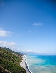
English: View to Nantien village, beach and rocky coastline from the coast path(Alangyi Ancient Trail) above Guanyinbi, Pingtung County.
中文(臺灣):從屏東縣觀音鼻上的沿海小徑(阿朗壹古道)所見到南田村、海灘、岩岸景觀。 |
| Date | |
| Source | https://www.flickr.com/photos/h760127/16693330862/ |
| Author | 中岑 范姜 |
Licensing
[edit]
| This image was originally posted to Flickr by KeroroTW at https://flickr.com/photos/53367994@N00/16693330862 (archive). It was reviewed on 12 November 2017 by FlickreviewR 2 and was confirmed to be licensed under the terms of the cc-by-sa-2.0. |
This file is licensed under the Creative Commons Attribution-Share Alike 2.0 Generic license.
- You are free:
- to share – to copy, distribute and transmit the work
- to remix – to adapt the work
- Under the following conditions:
- attribution – You must give appropriate credit, provide a link to the license, and indicate if changes were made. You may do so in any reasonable manner, but not in any way that suggests the licensor endorses you or your use.
- share alike – If you remix, transform, or build upon the material, you must distribute your contributions under the same or compatible license as the original.
File history
Click on a date/time to view the file as it appeared at that time.
| Date/Time | Thumbnail | Dimensions | User | Comment | |
|---|---|---|---|---|---|
| current | 09:19, 12 November 2017 | | 3,456 × 4,456 (8.5 MB) | Kai3952 (talk | contribs) | User created page with UploadWizard |
You cannot overwrite this file.
File usage on Commons
There are no pages that use this file.