File:View over Drombeg stone circle towards southwest, Somerville 1923.jpg
Jump to navigation
Jump to search

No higher resolution available.
View_over_Drombeg_stone_circle_towards_southwest,_Somerville_1923.jpg (601 × 466 pixels, file size: 86 KB, MIME type: image/jpeg)
Captions
Captions
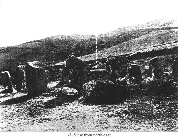
Photograph from Drombeg stone circle published in 1923 showing where the winter solstice sun would set.
Summary[edit]
| Description |
English: Photograph from w:Drombeg stone circle published in 1923 showing where the winter solstice sun would set. |
| Date | |
| Source | Immediate source https://www.cantab.net/users/michael.behrend/repubs/somerville_ori/images/fig_10b_35pc.jpg linked from https://www.cantab.net/users/michael.behrend/repubs/somerville_ori/pages/index.html in turn a copy of Somerville, Boyle (1923). "VIII.—Instances of Orientation in Prehistoric Monuments of the British Isles". Archaeologia. 73: 193–224. doi:10.1017/S026134090001033X. |
| Author | Boyle Somerville (1863–1936) |
| Camera location | | View this and other nearby images on: OpenStreetMap |
|---|
Licensing[edit]
|
This work is in the public domain in its country of origin and other countries and areas where the copyright term is the author's life plus 70 years or fewer. This work is in the public domain in the United States because it was published (or registered with the U.S. Copyright Office) before January 1, 1929. | |
| This file has been identified as being free of known restrictions under copyright law, including all related and neighboring rights. | |
File history
Click on a date/time to view the file as it appeared at that time.
| Date/Time | Thumbnail | Dimensions | User | Comment | |
|---|---|---|---|---|---|
| current | 18:26, 22 February 2020 | | 601 × 466 (86 KB) | Thincat (talk | contribs) | User created page with UploadWizard |
You cannot overwrite this file.
File usage on Commons
There are no pages that use this file.