File:Vilayet of the Archipelago (1881) Boundaries and Ethnic Makeup.png

Original file (7,088 × 6,898 pixels, file size: 186.83 MB, MIME type: image/png)
Captions
Captions
Summary[edit]
_Boundaries_and_Ethnic_Makeup.png&action=edit§ion=1)
| Description |
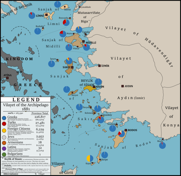
English: Map showing administrative boundaries and districtwise ethnic makeup based on 1881 Census of the Turkish Empire for Vilayet of the Archipelago (Cezayir-i Bahr-i Sefid).
Sources: Kemal H. Karpat, Ottoman Population 1830-1914: Demographic and Social Characteristics, 1985, University of Wisconsin
Vital CUINET, La Turquie d'Asie. Geographie administrative, statistique, descriptive et raisonné e de chaque province de l'Asie-Mineure, 1894, British Library Türkçe: Türk İmparatorluğu 1881 Nüfus Sayımı sonuçlarına göre Cezayir-i Bahr-i Sefid (Ege Adaları) Vilayeti idari sınırları ve kaza bazında etnik dağılımları gösteren harita.
Kaynaklar: Kemal H. Karpat, Ottoman Population 1830-1914: Demographic and Social Characteristics, 1985, University of Wisconsin Vital CUINET, La Turquie d'Asie. Geographie administrative, statistique, descriptive et raisonné e de chaque province de l'Asie-Mineure, 1894, British Library A Ritter zur Helle von Samo, Die Völker des osmanischen Reiches (Vienna, 1877)Deutsch: Die Karte zeigt die Verwaltungsgrenzen und bezirksweise ethnische Verteilung des Cezayir-i Bahr-i Sefid (Inseln des Weißen Meers) Vilayets nach dem Zensus des Türkisches Reiches von 1881
Quellen: Kemal H. Karpat, Ottoman Population 1830-1914: Demographic and Social Characteristics, 1985, University of Wisconsin Vital CUINET, La Turquie d'Asie. Geographie administrative, statistique, descriptive et raisonné e de chaque province de l'Asie-Mineure, 1894, British Library A Ritter zur Helle von Samo, Die Völker des osmanischen Reiches (Vienna, 1877)Magyar: 1881. évi Török Birodalomi népszámlálásabol Cezayir-i Bahr-i Sefid (Égei Szigetek) Vilayetje hivatalos határok és megyéki etnikai megoszlás térképe
Forrás: Kemal H. Karpat, Ottoman Population 1830-1914: Demographic and Social Characteristics, 1985, University of Wisconsin Vital CUINET, La Turquie d'Asie. Geographie administrative, statistique, descriptive et raisonné e de chaque province de l'Asie-Mineure, 1894, British Library A Ritter zur Helle von Samo, Die Völker des osmanischen Reiches (Vienna, 1877) |
| Date | |
| Source | Own work |
| Author | Berkaysnklf |
Licensing[edit]
_Boundaries_and_Ethnic_Makeup.png&action=edit§ion=2)
- You are free:
- to share – to copy, distribute and transmit the work
- to remix – to adapt the work
- Under the following conditions:
- attribution – You must give appropriate credit, provide a link to the license, and indicate if changes were made. You may do so in any reasonable manner, but not in any way that suggests the licensor endorses you or your use.
File history
Click on a date/time to view the file as it appeared at that time.
| Date/Time | Thumbnail | Dimensions | User | Comment | |
|---|---|---|---|---|---|
| current | 23:01, 14 April 2020 | | 7,088 × 6,898 (186.83 MB) | BRKY24 (talk | contribs) | Uploaded own work with UploadWizard |
You cannot overwrite this file.
File usage
The following 2 pages use this file:
Global file usage
The following other wikis use this file:
- Usage on de.wikipedia.org
- Usage on en.wikipedia.org
- Usage on sq.wikipedia.org
_Boundaries_and_Ethnic_Makeup.png&oldid=751485944)