File:Vindarnas Tempel, Infotavla.jpg
![File:Vindarnas Tempel, Infotavla.jpg](https://upload.wikimedia.org/wikipedia/commons/thumb/5/52/Vindarnas_Tempel%2C_Infotavla.jpg/800px-Vindarnas_Tempel%2C_Infotavla.jpg?20210726151245)
Original file (3,340 × 2,325 pixels, file size: 1.91 MB, MIME type: image/jpeg)
Captions
Captions
Summary
[edit]DescriptionVindarnas Tempel, Infotavla.jpg |
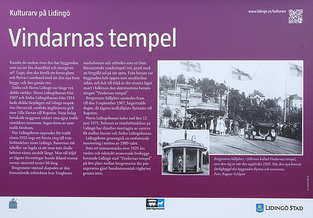
Svenska: Vindarnas Tempel, Infotavla uppsatt av Lidingö kommun |
Date | |
Source | Lidingö kommun |
Author | Kulturarv Lidingö kommun |
Camera location | 59° 21′ 46.23″ N, 18° 06′ 50.82″ E ![]() | View this and other nearby images on: OpenStreetMap | ![]() |
---|
Licensing
[edit]Public domainPublic domainfalsefalse |
![]() |
This Swedish photograph is in the public domain in Sweden because one of the following applies:
For photos in the first category created before 1969, also {{PD-1996}} usually applies. For photos in the second category published before 1929, also {{PD-US-expired}} usually applies. If the photographer died before 1954, {{PD-old-70}} should be used instead of this tag. If the author died before 1926, also {{PD-1996}} usually applies.![]() |
![]() |
File history
Click on a date/time to view the file as it appeared at that time.
Date/Time | Thumbnail | Dimensions | User | Comment | |
---|---|---|---|---|---|
current | 15:12, 26 July 2021 | ![]() | 3,340 × 2,325 (1.91 MB) | Holger.Ellgaard (talk | contribs) | Uploaded a work by Kulturarv Lidingö kommun from Lidingö kommun with UploadWizard |
You cannot overwrite this file.
File usage on Commons
There are no pages that use this file.
Metadata
This file contains additional information such as Exif metadata which may have been added by the digital camera, scanner, or software program used to create or digitize it. If the file has been modified from its original state, some details such as the timestamp may not fully reflect those of the original file. The timestamp is only as accurate as the clock in the camera, and it may be completely wrong.
Camera manufacturer | SONY |
---|---|
Camera model | DSC-HX90V |
Exposure time | 1/400 sec (0.0025) |
F-number | f/3.5 |
ISO speed rating | 80 |
Date and time of data generation | 13:45, 26 July 2021 |
Lens focal length | 4.1 mm |
Latitude | 59° 21′ 46.23″ N |
Longitude | 18° 6′ 50.83″ E |
Altitude | 10.7 meters above sea level |
Orientation | Normal |
Horizontal resolution | 350 dpi |
Vertical resolution | 350 dpi |
Software used | ArcSoft PhotoStudio |
File change date and time | 17:10, 26 July 2021 |
Y and C positioning | Co-sited |
Exposure Program | Normal program |
Exif version | 2.2 |
Date and time of digitizing | 13:45, 26 July 2021 |
Meaning of each component |
|
Image compression mode | 3 |
APEX brightness | 8.10703125 |
APEX exposure bias | 0 |
Maximum land aperture | 3.6171875 APEX (f/3.5) |
Metering mode | Pattern |
Light source | Unknown |
Flash | Flash did not fire, compulsory flash suppression |
Supported Flashpix version | 1 |
Color space | sRGB |
File source | Digital still camera |
Scene type | A directly photographed image |
Custom image processing | Normal process |
Exposure mode | Auto exposure |
White balance | Auto white balance |
Digital zoom ratio | 1 |
Focal length in 35 mm film | 24 mm |
Scene capture type | Standard |
Contrast | Normal |
Saturation | Normal |
Sharpness | Normal |
GPS time (atomic clock) | 11:45 |
Receiver status | Measurement in progress |
Measurement mode | 3-dimensional measurement |
Measurement precision | Poor (2.6099) |
Speed unit | Kilometers per hour |
Speed of GPS receiver | 0.59 |