File:Virginia Presidential Election Results 1948.svg
Jump to navigation
Jump to search

Size of this PNG preview of this SVG file: 800 × 354 pixels. Other resolutions: 320 × 141 pixels | 640 × 283 pixels | 1,024 × 453 pixels | 1,280 × 566 pixels | 2,560 × 1,131 pixels | 810 × 358 pixels.
Original file (SVG file, nominally 810 × 358 pixels, file size: 87 KB)
Captions
Captions
Add a one-line explanation of what this file represents
Summary[edit]
| Description |
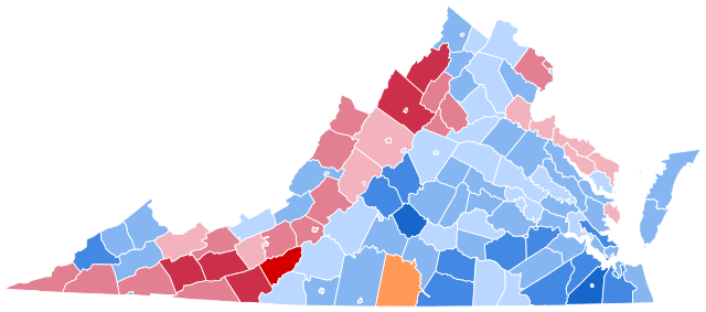
English: State election results in Virginia, by county – presidential election 1948.
Truman—>90%
Truman—80-90%
Truman—70-80%
Truman—60-70%
Truman—50-60%
Truman—40-50%
Truman—30-40%
Dewey—30-40%
Dewey—40-50%
Dewey—50-60%
Dewey—60-70%
Dewey—70-80%
Dewey—80-90%
Dewey—>90%
Thurmond—<40%
Thurmond—40-50%
Thurmond—50-60%
Thurmond—60-70%
Thurmond—70-80%
Thurmond—80-90%
Thurmond—>90% |
| Date | |
| Source | Own work |
| Author | TylerKutschbach |
_county_map,_cb_500k.svg)
Licensing[edit]
I, the copyright holder of this work, hereby publish it under the following license:
This file is licensed under the Creative Commons Attribution-Share Alike 4.0 International license.
- You are free:
- to share – to copy, distribute and transmit the work
- to remix – to adapt the work
- Under the following conditions:
- attribution – You must give appropriate credit, provide a link to the license, and indicate if changes were made. You may do so in any reasonable manner, but not in any way that suggests the licensor endorses you or your use.
- share alike – If you remix, transform, or build upon the material, you must distribute your contributions under the same or compatible license as the original.
File history
Click on a date/time to view the file as it appeared at that time.
| Date/Time | Thumbnail | Dimensions | User | Comment | |
|---|---|---|---|---|---|
| current | 17:51, 29 July 2023 | | 810 × 358 (87 KB) | CrookCoMaps61 (talk | contribs) | Shapes |
| 03:27, 20 January 2021 |  | 343 × 166 (25 KB) | TylerKutschbach (talk | contribs) | Fixed map. | |
| 22:14, 20 September 2020 |  | 343 × 166 (25 KB) | TylerKutschbach (talk | contribs) | Changed stroke width of lines. | |
| 04:47, 29 August 2020 |  | 343 × 166 (25 KB) | TylerKutschbach (talk | contribs) | Fixed county lines. | |
| 04:21, 15 July 2020 |  | 343 × 166 (100 KB) | TylerKutschbach (talk | contribs) | Uploaded own work with UploadWizard |
You cannot overwrite this file.
File usage on Commons
The following 5 pages use this file:
File usage on other wikis
The following other wikis use this file:
- Usage on en.wikipedia.org