File:Vojvodina18 19 cen.png
Aller à la navigation
Aller à la recherche
Taille de cet aperçu : 767 × 599 pixels. Autres résolutions : 307 × 240 pixels | 614 × 480 pixels | 983 × 768 pixels | 1 280 × 1 000 pixels | 2 000 × 1 563 pixels.
Fichier d’origine (2 000 × 1 563 pixels, taille du fichier : 220 kio, type MIME : image/png)
Légendes
Légendes
Ajoutez en une ligne la description de ce que représente ce fichier
Description
[modifier]
| Description |
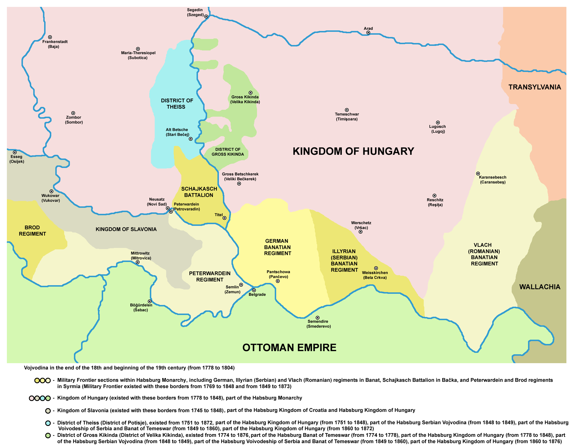
English: Location of the District of Potisje, District of Velika Kikinda, Šajkaš Battalion, and Banatian and Slavonian military frontier in Vojvodina (18th-19th century).
Српски / srpski: Потиски и Великокикиндски дистрикт, Шајкашки батаљон и Банатска и Славонска војна граница у Војводини (18-19. век)
Français : Localisation du bataillon de Šajkaš, Voïvodine |
| Date | 9 juillet 2006 (date de téléversement originale) - 2008-03-24 (current) |
| Source | Originally from en.wikipedia; description page is/was here. |
| Auteur | Original uploader was en:User:PANONIAN at en.wikipedia |
| Autorisation (Réutilisation de ce fichier) |
PD-self |
References
[modifier]
- Dr Dušan J. Popović, Srbi u Vojvodini, knjiga 2, Novi Sad, 1990.
- Drago Njegovan, Prisajedinjenje Vojvodine Srbiji, Novi Sad, 2004.
- Jovan M. Pejin, Iz prošlosti Kikinde, Kikinda, 2000.
- Branko Bešlin, Naseljavanje Nemaca u Vojvodini, Novi Sad, 2006.
- Suzana Milovanović, Potiska i pomoriška vojna granica 1702-1751, Novi Sad, 2003.
- Dragomir Jankov, Vojvodina - propadanje jednog regiona, Novi Sad, 2004.
- Dr Milenko Palić, Srbi u Mađarskoj - Ugarskoj do 1918, Novi Sad, 1995.
- Školski istorijski atlas, Zavod za izdavanje udžbenika Socijalističke Republike Srbije, Beograd, 1970.
- The Times History of Europe, Times Books, London, 2002.
- Fridrih Vilhelm fon Taube, Istorijski i geografski opis Kraljevine Slavonije i Vojvodstva Srema, Novi Sad, 1998.
Conditions d’utilisation
[modifier]
self made map by user:PANONIAN
| Cette œuvre a été placée dans le domaine public par son auteur, PANONIAN sur Wikipédia anglais. Ceci s’applique dans le monde entier. Dans certains pays, ceci peut ne pas être possible ; dans ce cas : PANONIAN accorde à toute personne le droit d’utiliser cette œuvre dans n’importe quel but, sans aucune condition, sauf celles requises par la loi. |
Historique du fichier
Cliquer sur une date et heure pour voir le fichier tel qu'il était à ce moment-là.
| Date et heure | Vignette | Dimensions | Utilisateur | Commentaire | |
|---|---|---|---|---|---|
| actuel | 13 juillet 2013 à 15:12 | | 2 000 × 1 563 (220 kio) | PANONIAN (d | contributions) | corrections |
| 10 décembre 2011 à 18:35 |  | 2 000 × 1 563 (209 kio) | PANONIAN (d | contributions) | aesthetics | |
| 4 août 2009 à 15:51 |  | 1 997 × 1 563 (209 kio) | PANONIAN (d | contributions) | ||
| 24 mars 2008 à 18:58 |  | 771 × 711 (49 kio) | Aristote2 (d | contributions) | {{Information |Description=Location of the Šajkaš Battalion, Vojvodina, Serbia/Localisation du bataillon de Šajkaš, Voïvodine, Serbie |Source=Originally from [http://en.wikipedia.org en.wikipedia]; description pa |
Vous ne pouvez pas remplacer ce fichier.
Utilisations locales du fichier
Les 4 pages suivantes utilisent ce fichier :
Utilisations du fichier sur d’autres wikis
Les autres wikis suivants utilisent ce fichier :
- Utilisation sur be.wikipedia.org
- Utilisation sur en.wikipedia.org
- Utilisation sur et.wikipedia.org
- Utilisation sur fa.wikipedia.org
- Utilisation sur fr.wikipedia.org
- Utilisation sur gl.wikipedia.org
- Utilisation sur hu.wikipedia.org
- Utilisation sur ja.wikipedia.org
- Utilisation sur lt.wikipedia.org
- Utilisation sur mk.wikipedia.org
- Utilisation sur nn.wikipedia.org
- Utilisation sur no.wikipedia.org
- Utilisation sur ro.wikipedia.org
- Utilisation sur ru.wikipedia.org
- Utilisation sur sh.wikipedia.org
- Utilisation sur sr.wikipedia.org
- Utilisation sur uk.wikipedia.org
Catégories :
- Maps of the Habsburg Military Frontier
- District of Theiss
- District of Gross Kikinda
- Maps of the Ottoman period in the history of Serbia
- Maps of the Habsburg period in the history of Serbia
- Maps of the history of Vojvodina
- Maps of the history of Banat
- Maps of the history of Bačka
- Maps of the history of Syrmia
- Maps of the Habsburg Monarchy