File:Vojvodina 1944 1945 01.png
ナビゲーションに移動
検索に移動

このプレビューのサイズ: 472 × 599 ピクセル。 その他の解像度: 189 × 240 ピクセル | 378 × 480 ピクセル | 916 × 1,162 ピクセル。
元のファイル (916 × 1,162 ピクセル、ファイルサイズ: 96キロバイト、MIME タイプ: image/png)
キャプション
キャプション
このファイルの内容を1行で記述してください
概要
[編集]
| 解説 |
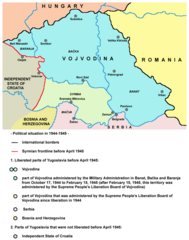
English: Vojvodina from October 1944 to April 1945 - territory of Military Administration in Banat, Bačka and Baranja and Syrmian frontline.
Српски / srpski: Војводина од октобра 1944. до априла 1945. године - подручје Војне управе у Банату, Бачкој и Барањи и линија Сремског фронта. |
| 日付 | 2009年6月29日 (当初のアップロード日) |
| 原典 | コンピュータが読み取れる情報は提供されていませんが、投稿者自身による著作物だと推定されます(著作権の主張に基づく) |
| 作者 | コンピュータが読み取れる情報は提供されていませんが、PANONIANだと推定されます(著作権の主張に基づく) |
ライセンス
[編集]
self made map by user:PANONIAN
| この著作物の著作権者である私は、この著作物における権利を放棄しパブリックドメインとします。これは全世界で適用されます。 一部の国では、これが法的に可能ではない場合があります。その場合は、次のように宣言します。 私は、あらゆる人に対して、法により必要とされている条件を除き、如何なる条件も課すことなく、あらゆる目的のためにこの著作物を使用する権利を与えます。 |
References
[編集]
- Nikola Gaćeša - Dušan Živković - Ljubica Radović, Istorija za III razred gimnazije prirodno-matematičkog smera i IV razred gimnazije opšteg i društveno-jezičkog smera, Beograd, 1997.
- Jelena Popov, Vojvodina i Srbija, Veternik, 2001.
- Dimitrije Boarov, Politička istorija Vojvodine, Novi Sad, 2001.
- Dragomir Jankov, Vojvodina - propadanje jednog regiona, Novi Sad, 2004.
- Istorijski atlas, Geokarta, Beograd, 1999.
- Školski istorijski atlas, Zavod za izdavanje udžbenika SR Srbije, Beograd, 1970.
- Povijesni atlas, Učila - Zagreb, Zagreb, 1971.
- Povijesni atlas za osnovnu školu, Kartografija - Tlos - Zagreb, Zagreb, 1975.
- Denis Šehić - Demir Šehić, Istorijski atlas sveta, Beograd, 2007.
- Istorijski atlas, Intersistem kartografija, Beograd, 2010.
ファイルの履歴
過去の版のファイルを表示するには、その版の日時をクリックしてください。
| 日付と時刻 | サムネイル | 寸法 | 利用者 | コメント | |
|---|---|---|---|---|---|
| 現在の版 | 2014年6月5日 (木) 21:20 | | 916 × 1,162 (96キロバイト) | PANONIAN (トーク | 投稿記録) | date change |
| 2011年12月10日 (土) 13:44 |  | 916 × 1,162 (96キロバイト) | PANONIAN (トーク | 投稿記録) | aesthetics | |
| 2009年6月29日 (月) 21:29 |  | 916 × 1,162 (96キロバイト) | PANONIAN (トーク | 投稿記録) | ==Description== * '''English''': Vojvodina from October 1944 to April 1945 - territory of Military Administration in Banat, Bačka and Baranja and Syrmian frontline. * '''Serbian''': Војводина од октобра 1944. до априла 1945. г� |
このファイルは上書きできません。
ファイルの使用状況
以下の 2 ページがこのファイルを使用しています:
グローバルなファイル使用状況
以下に挙げる他のウィキがこの画像を使っています:
- bg.wikipedia.org での使用状況
- en.wikipedia.org での使用状況
- ja.wikipedia.org での使用状況
- ru.wikipedia.org での使用状況
- sh.wikipedia.org での使用状況
- sv.wikipedia.org での使用状況
- uk.wikipedia.org での使用状況
- vi.wikipedia.org での使用状況
カテゴリ:
- SAP Vojvodina
- Military Administration in Banat, Bačka and Baranja
- Syrmian Front
- Maps of the history of Vojvodina
- Maps of the history of Syrmia
- Maps of the history of Bačka
- Maps of the history of Banat
- Maps of the history of Baranja
- Maps of Yugoslavia during World War II
- Maps of Serbia during World War II
- Maps of the Independent State of Croatia