File:Vongfong 2014 track.png
跳至導覽
跳至搜尋

預覽大小:800 × 520 像素。 其他解析度:320 × 208 像素 | 640 × 416 像素 | 1,024 × 665 像素 | 1,280 × 832 像素 | 2,700 × 1,754 像素。
原始檔案 (2,700 × 1,754 像素,檔案大小:889 KB,MIME 類型:image/png)
說明
說明
添加單行說明來描述出檔案所代表的內容
摘要
| 描述 |
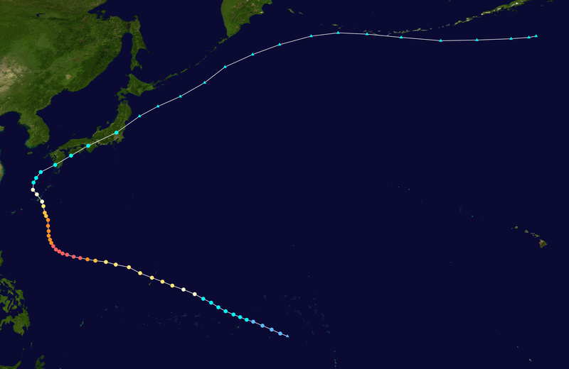
English: Track map of Typhoon Vongfong of the 2014 Pacific typhoon season. The points show the location of the storm at 6-hour intervals. The colour represents the storm's maximum sustained wind speeds as classified in the (see below), and the shape of the data points represent the nature of the storm, according to the legend below. Tropical depression (≤38 mph, ≤62 km/h)
Tropical storm (39–73 mph, 63–118 km/h)
Category 1 (74–95 mph, 119–153 km/h)
Category 2 (96–110 mph, 154–177 km/h)
Category 3 (111–129 mph, 178–208 km/h)
Category 4 (130–156 mph, 209–251 km/h)
Category 5 (≥157 mph, ≥252 km/h)
Unknown
Storm type |
||
| 日期 | 2014-10-01–2014-10-17 | ||
| 來源 | Created by Meow using Wikipedia:WikiProject Tropical cyclones/Tracks. The background image is from NASA. Tracking data is from the Joint Typhoon Warning Center[1]. | ||
| 作者 | Meow | ||
| Source code | Track map data table, if present below, is in HURDAT2 or ATCF format. See format details in [2] and [3], respectively.
|
授權條款
[編輯]| 此作品已由其作者,Meow,釋出至公有領域。此授權條款在全世界均適用。 這可能在某些國家不合法,如果是的話: Meow授予任何人有權利使用此作品於任何用途,除受法律約束外,不受任何限制。 |
檔案歷史
點選日期/時間以檢視該時間的檔案版本。
| 日期/時間 | 縮圖 | 尺寸 | 用戶 | 備註 | |
|---|---|---|---|---|---|
| 目前 | 2020年3月14日 (六) 19:26 | | 2,700 × 1,754(889 KB) | Supportstorm(對話 | 貢獻) | JTWC/JMA/OPC data |
| 2020年1月7日 (二) 07:07 |  | 2,700 × 2,340(1.14 MB) | Nino Marakot(對話 | 貢獻) | IBTrACS version + OPC wind data on ET points (ET continuation not documented on any BT) | |
| 2015年7月10日 (五) 04:03 |  | 2,700 × 1,754(1.09 MB) | Cyclonebiskit(對話 | 貢獻) | JTWC best track | |
| 2014年11月22日 (六) 03:34 |  | 2,700 × 1,797(953 KB) | Supportstorm(對話 | 貢獻) | Precise points from OPC graphics/ added missing point | |
| 2014年11月21日 (五) 12:43 |  | 2,700 × 1,787(950 KB) | Meow(對話 | 貢獻) | Extended with the RSMC best track data and the OPC reports. | |
| 2014年11月18日 (二) 04:21 |  | 2,700 × 1,794(945 KB) | Supportstorm(對話 | 貢獻) | Extended extra-tropical track from NOAA OPC | |
| 2014年10月14日 (二) 17:24 |  | 2,700 × 2,414(1.02 MB) | Meow(對話 | 貢獻) | 10-04 06Z (operationally final) | |
| 2014年10月13日 (一) 13:49 |  | 2,700 × 2,092(640 KB) | Meow(對話 | 貢獻) | 10-13 12Z | |
| 2014年10月13日 (一) 13:49 |  | 3,000 × 2,325(768 KB) | Krit-tonkla(對話 | 貢獻) | 10-13 12Z | |
| 2014年10月12日 (日) 13:13 |  | 2,700 × 1,843(422 KB) | Meow(對話 | 貢獻) | 10-12 12Z |
無法覆蓋此檔案。
檔案用途
下列頁面有用到此檔案:
全域檔案使用狀況
以下其他 wiki 使用了這個檔案:
- de.wikipedia.org 的使用狀況
- en.wikipedia.org 的使用狀況
- es.wikipedia.org 的使用狀況
- ja.wikipedia.org 的使用狀況
- ko.wikipedia.org 的使用狀況
- pt.wikipedia.org 的使用狀況
- th.wikipedia.org 的使用狀況
- tl.wikipedia.org 的使用狀況
- vi.wikipedia.org 的使用狀況
- www.wikidata.org 的使用狀況
- zh-min-nan.wikipedia.org 的使用狀況
- zh-yue.wikipedia.org 的使用狀況
- zh.wikipedia.org 的使用狀況