File:Vysočina obec, CZ180225-171.jpg
Jump to navigation
Jump to search

Size of this preview: 800 × 450 pixels. Other resolutions: 320 × 180 pixels | 640 × 360 pixels | 1,024 × 576 pixels | 1,280 × 719 pixels | 2,560 × 1,439 pixels | 4,896 × 2,752 pixels.
Original file (4,896 × 2,752 pixels, file size: 3.99 MB, MIME type: image/jpeg)
Captions
Captions
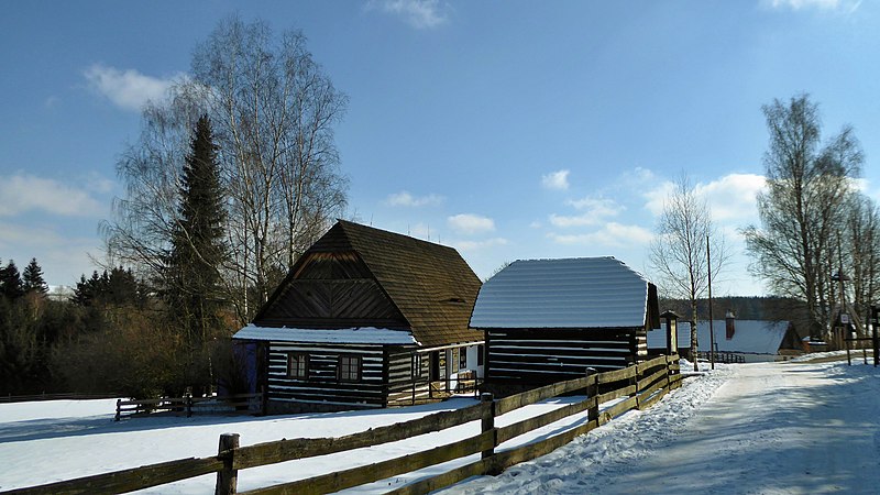
Buildings of traditional folk architecture in the Czech Republic.
Summary
[edit]
| Description |
English: Merry Hill (Czech name: Veselý Kopec), entrance to the exposition of folk architecture and technical buildings of the Open-air Museum Vysočina (formerly with name Set of Folk Buildings Vysočina). The small hamlet of Merry Hill is a part of the village Vysočina in the Pardubický Region on the territory of the Czech Republic. In the area of a museum is green touristic route of the Czech Tourists Club, the all-year-round accessible (section trail: Králova Pila – Veselý Kopec – Dřevíkov). In the route also Homeland trail the Landscape of Chrudimka River (point number 9 – Veselý Kopec). Photo location: Czechia, Pardubice Region, village Vysočina, small hamlet Merry Hill, the landscape area Stružinecká knoll land (geomorphological district).
Source of information:Čeština: Veselý Kopec, vstup do expozice lidové architektury a technického stavitelství, lidově nazývané skanzen, součást Muzea v přírodě Vysočina (dříve Soubor lidových staveb Vysočina). Malá vesnička Veselý Kopec je část obce Vysočina v Pardubickém kraji na území České republiky. Areálem muzea vedena zeleně značená turistická trasa Klubu českých turistů, celoročně přístupná (úsek: Králova Pila – Veselý Kopec – Dřevíkov). V trase také vlastivědná stezka Krajem Chrudimky (stanoviště č. 9 – Veselý Kopec) a Turistická cesta malíře-krajináře Františka Kavána. Foto lokace: Česko, Pardubický kraj, obec Vysočina, vesnička Veselý Kopec, krajinná oblast Stružinecké pahorktiny (geomorfologický okrsek), foto azimut 120°. |
| Date | |
| Source | Own work |
| Author | Josef Kreuz (PEPan) |
| Camera location | | View this and other nearby images on: OpenStreetMap |
|---|
Zdroje informací:
[edit]
- Mapy.cz, turistická mapa (letecký pohled) – kompozice: Obec Vysočina / Dřevíkov a Veselý Kopec viz
- Národní památkový ústav, památkový katalog – soubor lidových staveb, Veselý Kopec viz
- Muzeum v přírodě Vysočina (dříve Soubor lidových staveb Vysočina) – expozice Veselý Kopec: česká oficiální webová prezentace viz
Licensing
[edit]
I, the copyright holder of this work, hereby publish it under the following license:
This file is licensed under the Creative Commons Attribution-Share Alike 4.0 International license.
- You are free:
- to share – to copy, distribute and transmit the work
- to remix – to adapt the work
- Under the following conditions:
- attribution – You must give appropriate credit, provide a link to the license, and indicate if changes were made. You may do so in any reasonable manner, but not in any way that suggests the licensor endorses you or your use.
- share alike – If you remix, transform, or build upon the material, you must distribute your contributions under the same or compatible license as the original.
File history
Click on a date/time to view the file as it appeared at that time.
| Date/Time | Thumbnail | Dimensions | User | Comment | |
|---|---|---|---|---|---|
| current | 12:14, 28 February 2018 | | 4,896 × 2,752 (3.99 MB) | PEPan (talk | contribs) | User created page with UploadWizard |
You cannot overwrite this file.
File usage on Commons
There are no pages that use this file.
File usage on other wikis
The following other wikis use this file:
- Usage on cs.wikipedia.org