File:W-RSimpleMap.gif
Jump to navigation
Jump to search

Size of this preview: 432 × 599 pixels. Other resolutions: 173 × 240 pixels | 346 × 480 pixels | 554 × 768 pixels | 738 × 1,024 pixels | 1,960 × 2,718 pixels.
Original file (1,960 × 2,718 pixels, file size: 2.08 MB, MIME type: image/gif)
Captions
Captions
Add a one-line explanation of what this file represents
Summary
[edit]
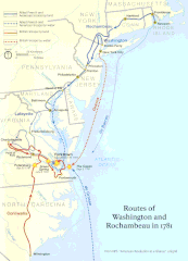
| Description | Official National Park Service map of the Washington-Rochambeau Revolutionary Route |
| Date | |
| Source | http://www.nps.gov/boso/w-r |
| Author | National Park Service |
| Permission (Reusing this file) |
"The maps at this site are in the public domain. You may use National Park Service maps provided that you agree to assume complete legal responsibility for problems resulting from their use. Although National Park Service maps are easy to modify, understand that modifications can adversely alter the meaning and accuracy of the original data. Law prohibits you from using the National Park Service seal or claiming National Park Service endorsement with downloaded maps." [1] |
Licensing
[edit]
| This image or media file contains material based on a work of a National Park Service employee, created as part of that person's official duties. As a work of the U.S. federal government, such work is in the public domain in the United States. See the NPS website and NPS copyright policy for more information. |

|
This map image could be re-created using vector graphics as an SVG file. This has several advantages; see Commons:Media for cleanup for more information. If an SVG form of this image is available, please upload it and afterwards replace this template with
{{vector version available|new image name}}.
It is recommended to name the SVG file “W-RSimpleMap.svg”—then the template Vector version available (or Vva) does not need the new image name parameter. |
File history
Click on a date/time to view the file as it appeared at that time.
| Date/Time | Thumbnail | Dimensions | User | Comment | |
|---|---|---|---|---|---|
| current | 19:39, 13 April 2008 | | 1,960 × 2,718 (2.08 MB) | Evrik (talk | contribs) | == Summary == {{Information |Description = Official National Park Service map of the Washington-Rochambeau Revolutionary Route |Source = [http://www.nps.gov/boso/w-r] |Date = |
You cannot overwrite this file.
File usage on Commons
The following page uses this file:
File usage on other wikis
The following other wikis use this file:
- Usage on ca.wikipedia.org
- Usage on el.wikipedia.org
- Usage on en.wikipedia.org
- Newport, Rhode Island
- Siege of Yorktown
- Jean-Baptiste Donatien de Vimeur, comte de Rochambeau
- James Manning (minister)
- France in the American Revolutionary War
- Yorktown campaign
- Washington–Rochambeau Revolutionary Route
- March Route of Rochambeau's Army: Scotland Road
- Fourth Camp of Rochambeau's Army
- March Route of Rochambeau's Army: Manship Road-Barstow Road
- March Route of Rochambeau's Army: Palmer Road
- March Route of Rochambeau's Army: Plainfield Pike
- March Route of Rochambeau's Army: Bailey Road
- March Route of Rochambeau's Army: Reservoir Road
- March Route of Rochambeau's Army: Ridgebury Road
- List of historic sites preserved along Rochambeau's route
- User:Ile da france b17/sandbox
- Usage on en.wikivoyage.org
- Usage on es.wikipedia.org
- Usage on fa.wikipedia.org
- Usage on fr.wikipedia.org
- Usage on he.wikipedia.org
- Usage on it.wikipedia.org
- Usage on ja.wikipedia.org
- Usage on ko.wikipedia.org
- Usage on pt.wikipedia.org
- Usage on ru.wikipedia.org
- Usage on www.wikidata.org
- Usage on zh.wikipedia.org