File:WV plateau.jpg

Archivo original (800 × 784 píxeles; tamaño de archivo: 472 kB; tipo MIME: image/jpeg)
Leyendas
Leyendas
Transferido desde en.wikipedia a Commons por Maksim.
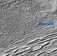
Relief Map: Cumberland Plateau, West Virginia and "Ridge and Valley" region of Virginia
Image is Shaded Relief Imagery, derived from the US Geological Survey National Elevation Dataset, modified by Pollinator. USGS-authored or produced data and information are in the public domain.
(Point of reference: Bluefield, West Virginia is on the Virginia/West Virginia border)
On the southeastern portion of this map is the folded Appalachians of Virginia, also known as the Ridge-and-valley Appalachians, which are the roots of true ancient mountains, uplifted once again, with the harder rock layers forming ridges and the more erodable rocks becoming valleys.
A major fault line runs from southwest to northeast dividing the folded mountains from the Cumberland Plateau of West Virginia, a dissected plateau that forms the majority of the image. This area of sedimentary rock (including many coal) veins is, geologically speaking, not true mountains, but merely was uplifted and eroded. Note that the area is actually more rugged than the folded mountains, though not as high.
Esta imagen está en el dominio público, ya que contiene materiales que originalmente vinieron del Servicio Geológico de los Estados Unidos de América, una agencia del Departamento del Interior. Para obtener más información, consulte la política oficial de derechos de los USGS.
|
| date/time | username | edit summary |
|---|---|---|
| 01:20, 12 February 2005 | en:User:RedWolf | ({{PD-USGov-Interior-USGS}}) |
| 06:23, 8 November 2004 | en:User:SimonP | |
| 20:08, 21 August 2004 | en:User:Pollinator | (tweak and wikify) |
| 19:55, 21 August 2004 | en:User:Pollinator | (public domain) |
| 19:52, 21 August 2004 | en:User:Pollinator | (link repair) |
| 19:50, 21 August 2004 | en:User:Pollinator | (Photo caption) |
| 19:38, 21 August 2004 | en:User:Pollinator | (Relief Map: Cumberland Plateau, West Virginia and "Ridge and Valley" region of Virginia) |
Registro original de carga
[editar]
Legend: (cur) = this is the current file, (del) = delete this old version, (rev) = revert to this old version.
Click on date to download the file or see the image uploaded on that date.
- (del) (cur) 19:38, 21 August 2004 . . en:User:Pollinator Pollinator ( en:User_talk:Pollinator Talk) . . 800x784 (483656 bytes) (Relief Map: Cumberland Plateau, West Virginia and "Ridge and Valley" region of Virginia)
Historial del archivo
Haz clic sobre una fecha y hora para ver el archivo tal como apareció en ese momento.
| Fecha y hora | Miniatura | Dimensiones | Usuario | Comentario | |
|---|---|---|---|---|---|
| actual | 18:47 5 feb 2006 | | 800 × 784 (472 kB) | Maksim (discusión | contribs.) | La bildo estas kopiita de wikipedia:en. La originala priskribo estas: Relief Map: Cumberland Plateau, West Virginia and "Ridge and Valley" region of Virginia Image is Shaded Relief Imagery, derived from the US Geological Survey National Elevation Datase |
No puedes sobrescribir este archivo.
Usos del archivo
No hay páginas que enlacen a este archivo.
Uso global del archivo
Las wikis siguientes utilizan este archivo:
- Uso en ca.wikipedia.org
- Uso en da.wikipedia.org
- Uso en en.wikipedia.org
- Uso en eo.wikipedia.org
- Uso en es.wikipedia.org
- Uso en it.wikipedia.org
- Uso en ja.wikipedia.org
- Uso en nn.wikipedia.org
- Uso en pt.wikipedia.org