File:Wadano and Mizotani Aerial photograph 1975.jpg
Jump to navigation
Jump to search

Size of this preview: 800 × 596 pixels. Other resolutions: 320 × 238 pixels | 640 × 476 pixels | 1,024 × 762 pixels | 1,280 × 953 pixels | 2,097 × 1,561 pixels.
Original file (2,097 × 1,561 pixels, file size: 1.01 MB, MIME type: image/jpeg)
Captions
Captions
Add a one-line explanation of what this file represents
Summary
[edit]
| Description |
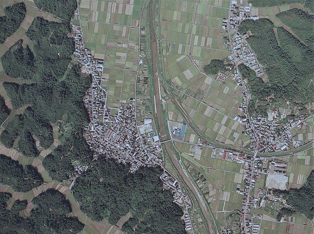
日本語: 京都府京丹後市弥栄町和田野(左)と弥栄町溝谷(右)の空中写真。中央を南北に流れるのは竹野川。右下のグラウンドは京丹後市立弥栄中学校。1975年9月20日撮影。整理番号CKK756、コース番号C10、写真番号12。 |
| Date | |
| Source | 地図・空中写真閲覧サービス |
| Author | 国土交通省 |
Licensing
[edit]

|
The copyright holder of this file, the Ministry of Land, Infrastructure, Transport and Tourism of Japan, allows anyone to use it for any purpose, provided that the copyright holder is properly attributed. Redistribution, derivative work, commercial use, and all other use is permitted. |
Attribution:
Copyright © National Land Image Information (Color Aerial Photographs), Ministry of Land, Infrastructure, Transport and Tourism
|
 |
This image is copyrighted by the Ministry of Land, Infrastructure, Transport and Tourism of Japan. For terms of use, see the stipulation to use of National Land Information (in Japanese) and message from MLIT (in Japanese and English). When you display this image on an article, include the following phrase in the description: "Made based on National Land Image Information (Color Aerial Photographs), Ministry of Land, Infrastructure, Transport and Tourism".
|
File history
Click on a date/time to view the file as it appeared at that time.
| Date/Time | Thumbnail | Dimensions | User | Comment | |
|---|---|---|---|---|---|
| current | 14:24, 11 September 2022 | | 2,097 × 1,561 (1.01 MB) | Asturio Cantabrio (talk | contribs) | Uploaded a work by 国土交通省 from 地図・空中写真閲覧サービス with UploadWizard |
You cannot overwrite this file.
File usage on Commons
There are no pages that use this file.