File:Waibelhube gedenkstein.jpg
Jump to navigation
Jump to search

Size of this preview: 603 × 599 pixels. Other resolutions: 241 × 240 pixels | 483 × 480 pixels | 773 × 768 pixels | 1,030 × 1,024 pixels | 2,061 × 2,048 pixels | 3,437 × 3,416 pixels.
Original file (3,437 × 3,416 pixels, file size: 1.71 MB, MIME type: image/jpeg)
Captions
Captions
Add a one-line explanation of what this file represents
Summary
[edit]
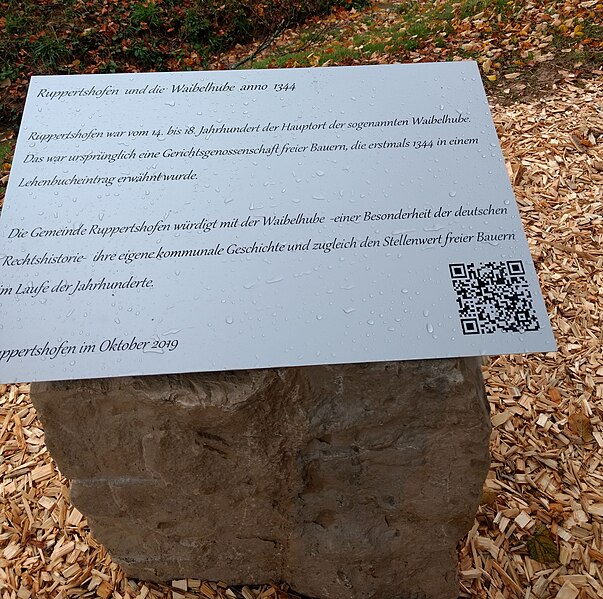
| Description | Gedenkstein an die Waibelhube bei Ruppertshofen. INSCHRIFT: Ruppertshofen und die Waibelhube anno 1344 | Ruppertshofen war vom 14. bis 18. Jahrhundert der Hauptort der sogenannten Waibelhube. | Das war ursprünglich eine Gerichtsgenossenschaft freier Bauern, die erstmals 1344 in einem | Lehenbucheintrag erwähnt wurde.| Die Gemeinde Ruppertshofen würdigt mit der Waibelhube - einer Besonderheit der deutschen | Rechtshistorie - ihre eigene kommunale Geschichte und zugleich den Stellenwert freier Bauern | im Laufe der Jahrhunderte. | Ruppertshofen im Oktober 2019" |
| Date | 18. Oktober 2019 (Enthüllung) |
| Source | Own work |
| Author | Klaus Graf |
| Camera location | | View this and other nearby images on: OpenStreetMap |
|---|
Licensing
[edit]
This file is licensed under the Creative Commons Attribution 3.0 Unported license.
- You are free:
- to share – to copy, distribute and transmit the work
- to remix – to adapt the work
- Under the following conditions:
- attribution – You must give appropriate credit, provide a link to the license, and indicate if changes were made. You may do so in any reasonable manner, but not in any way that suggests the licensor endorses you or your use.
File history
Click on a date/time to view the file as it appeared at that time.
| Date/Time | Thumbnail | Dimensions | User | Comment | |
|---|---|---|---|---|---|
| current | 19:59, 20 October 2019 | | 3,437 × 3,416 (1.71 MB) | Historiograf (talk | contribs) | {{Information |Description=Gedenkstein an die Waibelhube bei Ruppertshofen |Source=own |Date=18. Oktober 2019 (Enthüllung) |Author=Klaus Graf |Permission= |other_versions= }} Category:Waibelhube (Ruppertshofen) |
You cannot overwrite this file.
File usage on Commons
There are no pages that use this file.
File usage on other wikis
The following other wikis use this file:
- Usage on de.wikipedia.org