File:Wake Island air.JPG
跳至導覽
跳至搜尋

預覽大小:800 × 362 像素。 其他解析度:320 × 145 像素 | 640 × 290 像素 | 1,024 × 463 像素 | 1,965 × 889 像素。
原始檔案 (1,965 × 889 像素,檔案大小:312 KB,MIME 類型:image/jpeg)
說明
說明
添加單行說明來描述出檔案所代表的內容
摘要
[編輯]
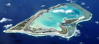
| 描述 | Wake Island was devastated by 185 mile per hour winds and a storm surge caused by Super Typhoon Ioke in August of 2009. The waves surging approx. 300ft off the northern coast and lagoon entrance is a result of the reef rapidly rising to within a few feet of the surface. (U.S. Air Force photo/Tech. Sgt. Shane A. Cuomo) source: http://www.af.mil/news/story_media.asp?storyID=123035748 License: |
| 日期 | (UTC) |
| 來源 | |
| 作者 |
|
| 這是一張修飾過的圖片,即本圖片是用軟體修改過後的版本,修改的方式或內容有:Cropped to island, level balance, sharpened slightly, edited out end of boom.。原版圖片來源:KC-135 Stratotanker boom.JPG。修改者:Hohum。
|
授權條款
[編輯]
|
|
 |
原始上傳日誌
[編輯]
This image is a derivative work of the following images:
- File:KC-135_Stratotanker_boom.JPG licensed with PD-USGov-Military-Air Force
- 2006-12-19T16:30:51Z Uwe W. 3000x1993 (619373 Bytes) Fuel for the Pacific A boom from a KC-135 Stratotanker is visible as it flies Dec. 15 over Wake Island. The KC-135 is from the 74th Air Refueling Squadron, part of the 434th Air Refueling Wing from Grissom Air Force Reserve
Uploaded with derivativeFX
檔案歷史
點選日期/時間以檢視該時間的檔案版本。
| 日期/時間 | 縮圖 | 尺寸 | 使用者 | 備註 | |
|---|---|---|---|---|---|
| 目前 | 2009年7月22日 (三) 18:06 | | 1,965 × 889(312 KB) | Hohum(留言 | 貢獻) | {{Information |Description=Fuel for the Pacific A boom from a KC-135 Stratotanker is visible as it flies Dec. 15 over Wake Island. The KC-135 is from the 74th Air Refueling Squadron, part of the 434th Air Refueling Wing from Grissom Air Force Reserve Bas |
無法覆蓋此檔案。
檔案用途
下列3個頁面有用到此檔案:
全域檔案使用狀況
以下其他 wiki 使用了這個檔案:
- als.wikipedia.org 的使用狀況
- ar.wikipedia.org 的使用狀況
- arz.wikipedia.org 的使用狀況
- ast.wikipedia.org 的使用狀況
- bg.wikipedia.org 的使用狀況
- br.wikipedia.org 的使用狀況
- ceb.wikipedia.org 的使用狀況
- ce.wikipedia.org 的使用狀況
- cs.wikipedia.org 的使用狀況
- da.wikipedia.org 的使用狀況
- de.wikipedia.org 的使用狀況
- en.wikipedia.org 的使用狀況
- Micronesia
- Wake Island
- Atoll
- Wake Island (film)
- Shigematsu Sakaibara
- Wake Island Device
- Battle of Wake Island
- Japanese destroyer Hayate (1925)
- Japanese destroyer Kisaragi (1925)
- Wake Island rail
- Winfield S. Cunningham
- Hurricane Ioke
- Wake Island Time Zone
- Wake Island Airfield
- Typhoon Olive (1952)
- Wake Island Conference
- KEAD
- Japanese destroyer Aoi (1920)
- Libelle (barque)
- Suwa Maru
- Japanese submarine Ro-66
- Japanese submarine Ro-60
- User:Northamerica1000/Topics
- Takasago Maru
- SS Suremico
- Japanese destroyer Hagi (1920)
- Template:Wake
- Peale Island
- Wilkes Island
- es.wikipedia.org 的使用狀況
- eu.wikipedia.org 的使用狀況
- fa.wikipedia.org 的使用狀況
- fi.wikipedia.org 的使用狀況
檢視此檔案的更多全域使用狀況。