File:Walbrzych railway network.png
Walbrzych_railway_network.png (387 × 574 pixels, file size: 76 KB, MIME type: image/png)
Captions
Captions

|
This transport map image could be re-created using vector graphics as an SVG file. This has several advantages; see Commons:Media for cleanup for more information. If an SVG form of this image is available, please upload it and afterwards replace this template with
{{vector version available|new image name}}.
It is recommended to name the SVG file “Walbrzych railway network.svg”—then the template Vector version available (or Vva) does not need the new image name parameter. |
Summary
[edit]
| Description |
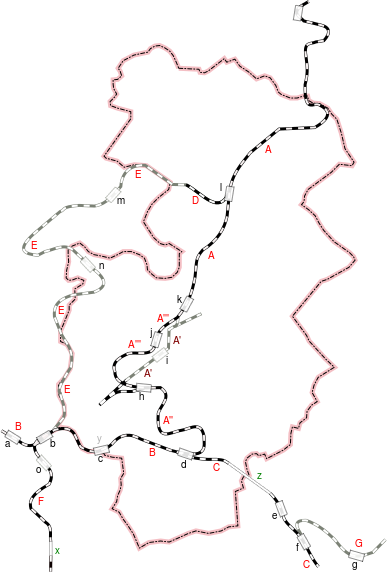
Polski: Sieć kolejowa Wałbrzycha w granicach administracyjnych miasta z 2017 r. i okolicy.
Symbol czarny: czynne. Symbol szary: nieczynne lub rozebrane.
Stacje i przystanki
Tunele:
Linie kolejowe:
źródła danych: PKP Polskie Linie Kolejowe S.A.: Mapa linii kolejowych w Polsce zarządzanych przez PKP Polskie Linie Kolejowe S.A. oraz innych zarządców (pol.). plk-sa.pl, 2015-12-09. [dostęp 2016-01-02]. Andrzej Scheer: Zapomniane linie kolejowe w województwie wałbrzyskim (pol.). W: Rocznik Świdnicki 84, Towarzystwo Regionalne Ziemi Świdnickiej, Świdnica, s. 38–98 [on-line]. bazakolejowa.pl/_fervojoj. [dostęp 2014-08-05]. Mapa turystyczna Powiat Wałbrzyski, Skala 1:50 000. Wydanie IV powiększone. Wydawnictwo Turystyczne PLAN, Jelenia Góra: 2012. ISBN 978-83-62917-63-1 |
| Date | |
| Source | Own work |
| Author | Michał Dadełło |
Licensing
[edit]
- You are free:
- to share – to copy, distribute and transmit the work
- to remix – to adapt the work
- Under the following conditions:
- attribution – You must give appropriate credit, provide a link to the license, and indicate if changes were made. You may do so in any reasonable manner, but not in any way that suggests the licensor endorses you or your use.
- share alike – If you remix, transform, or build upon the material, you must distribute your contributions under the same or compatible license as the original.
File history
Click on a date/time to view the file as it appeared at that time.
| Date/Time | Thumbnail | Dimensions | User | Comment | |
|---|---|---|---|---|---|
| current | 01:55, 29 September 2017 | | 387 × 574 (76 KB) | Montiverdi (talk | contribs) | poprawa braków |
| 01:53, 29 September 2017 |  | 387 × 574 (75 KB) | Montiverdi (talk | contribs) | User created page with UploadWizard |
You cannot overwrite this file.
File usage on Commons
The following 4 pages use this file:
File usage on other wikis
The following other wikis use this file:
- Usage on pl.wikipedia.org