File:Waldseemuller map 2.jpg

Fitxer original (13.708 × 7.590 píxels, mida del fitxer: 19,65 Mo, tipus MIME: image/jpeg)
Llegendes
Llegendes
Resum[modifica]
| Descripció |
العربية: خريطة ڤالدسيمولير العائدة لِسنة 1507م. هذه الخريطة هي الأولى التي أوردت اسم «أمريكا» وأوَّل خريطة فصلت الأمريكتين عن آسيا. هذه النسخة هي الوحيدة الباقية، وقد اشترتها مكتبة الكونغرس سنة 2001م مُقابل 10 ملايين دولار أمريكي.
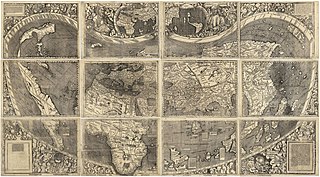
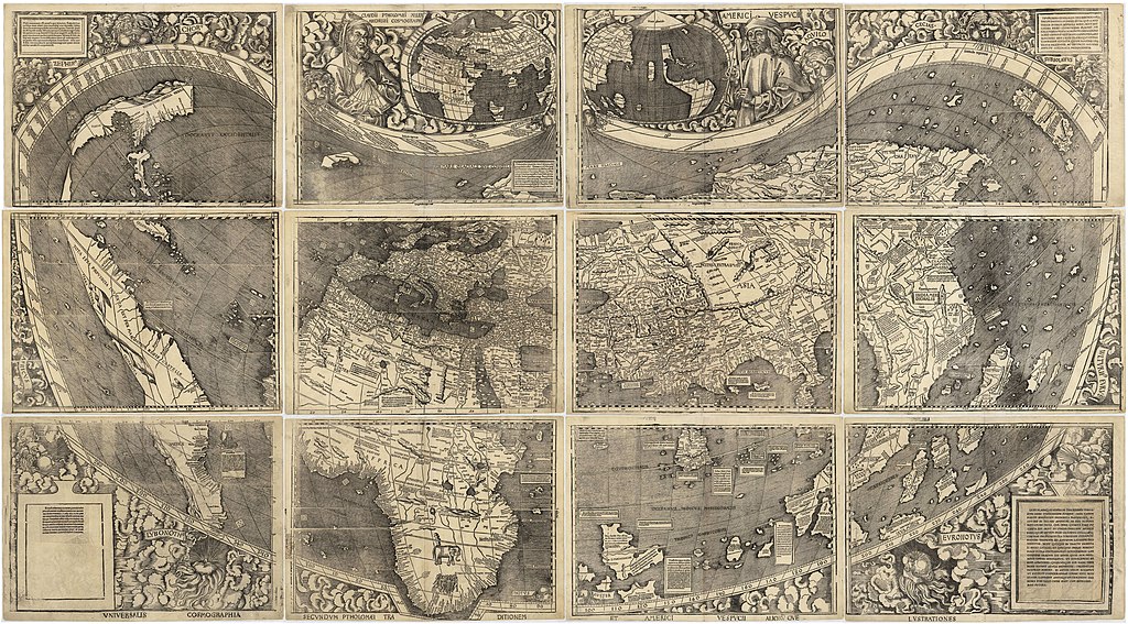
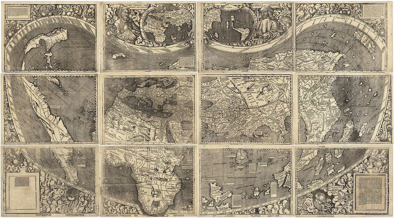
English: Waldseemüller map from 1507 is the first map to include the name "America" and the first to depict the Americas as separate from Asia. There is only one surviving copy of the map, which was purchased by the Library of Congress in 2001 for $10 million.
Français : Le planisphère de Waldseemüller de 1507 est la première carte mentionnant le nom "America" et la première à décrire les Amériques séparées de l'Asie. Il ne reste plus qu'une seule copie du planisphère encore existante à ce jour, acquise par la bibliothèque du Congrès en 2001 pour la somme de 10 millions de dollars. |
|||||||||||||||||||||||
| Data | ||||||||||||||||||||||||
| Font | https://www.loc.gov/resource/g3200.ct000725 | |||||||||||||||||||||||
| Autor |
|
|||||||||||||||||||||||
| Altres versions |
|
|||||||||||||||||||||||


Assessment[modifica]
|

Llicència[modifica]
|
Aquest material està en domini públic als Estats Units i als altres països on el dret d'autor s'estén per 100 anys (o menys) després de la mort de l'autor. Aquesta obra es troba en el domini públic als Estats Units d'Amèrica per haver estat publicada abans de l'1 de gener de 1929. | |
| Aquest fitxer està identificat com a lliure de restriccions conegudes sota la llei de drets d'autor, inclosos els drets veïns. | |
Historial del fitxer
Cliqueu una data/hora per veure el fitxer tal com era aleshores.
| Data/hora | Miniatura | Dimensions | Usuari/a | Comentari | |
|---|---|---|---|---|---|
| actual | 17:37, 27 oct 2008 | | 13.708 × 7.590 (19,65 Mo) | Jackaranga (discussió | contribucions) | {{Information |Description={{en|1=waldseemuller map, full page from http://memory.loc.gov/cgi-bin/map_item.pl?data=/home/www/data/gmd/gmd3/g3200/g3200/ct000725.jp2&style=gmd&itemLink=r?ammem/gmd:@field(NUMBER+@band(g3200+ct000725))&title=Universalis%20cos |
No podeu sobreescriure aquest fitxer.
Ús del fitxer
Les 27 pàgines següents utilitzen aquest fitxer:
- Waldseemüller map
- User:AMHQ/Favorites
- User:Yann/Featured images/2019-2023
- User:Yann/Featured pictures by others
- User:Yann/Valued images/2017-2019
- User:Yann/Valued images by others
- Commons:Featured picture candidates/File:Waldseemuller map 2.jpg
- Commons:Featured picture candidates/Log/January 2019
- Commons:Featured pictures/Non-photographic media/Maps
- Commons:Featured pictures/chronological/2019-A
- Commons:Picture of the Year/2019/Candidates
- Commons:Picture of the Year/2019/R1/Gallery/2019-A
- Commons:Picture of the Year/2019/R1/Gallery/ALL
- Commons:Picture of the Year/2019/R1/Gallery/M01
- Commons:Picture of the Year/2019/R1/Gallery/Maps
- Commons:Picture of the Year/2019/R1/v/Waldseemuller map 2.jpg
- Commons:Valued image candidates/Waldseemuller map 2.jpg
- File:1507 Waldseemüller world map - Taprobana detail.jpg
- File:Map of the Waldseemüller globe in nearly rectangular projection.jpg
- File:Map of the Waldseemüller globe in nearly rectangular projection 2.jpg
- File:TERRA·VLTERIꝰ·INCOGNITA.jpg
- File:Waldseemuller map, complete.jpg
- File:Waldseemuller map, complete 100%.jpg
- File:Waldseemuller map.jpg
- File:Waldseemuller map Caribbean.jpg
- File:Waldseemüller Globensegmente Cim107-2.jpg
- Category:Waldseemüller map
Ús global del fitxer
Utilització d'aquest fitxer en altres wikis:
- Utilització a af.wikipedia.org
- Utilització a als.wikipedia.org
- Utilització a ar.wikipedia.org
- الأمريكتان
- العصر الحديث
- خريطة فالدسيمولير
- استكشاف أمريكا الشمالية
- بوابة:جغرافيا/صورة مختارة/أرشيف
- ويكيبيديا:صور مختارة/رسومات وجداول وخرائط/خرائط
- ويكيبيديا:ترشيحات الصور المختارة/خريطة فالدسيمولير
- ويكيبيديا:صورة اليوم المختارة/مارس 2018
- قالب:صورة اليوم المختارة/2018-03-24
- بوابة:جغرافيا/صورة مختارة/13
- ويكيبيديا:صورة اليوم المختارة/سبتمبر 2022
- قالب:صورة اليوم المختارة/2022-09-03
- Utilització a ast.wikipedia.org
- Utilització a az.wikipedia.org
- Utilització a bg.wikipedia.org
- Utilització a bn.wikipedia.org
- Utilització a br.wikipedia.org
- Utilització a ca.wikipedia.org
- Utilització a cs.wikipedia.org
- Utilització a cy.wikipedia.org
- Utilització a da.wikipedia.org
- Utilització a de.wikipedia.org
- 16. Jahrhundert
- Christoph Kolumbus
- Neuzeit
- Martin Waldseemüller
- Weltkarte
- Benutzer:Mondamo/karten
- Liste historischer Weltkarten
- UNESCO-Kultur- und -Naturerbe
- Benutzer:GiFontenelle/Entwurf/Q131454, bibliothek
- Benutzer:Muhali/Waldseemüller Karte
- Benutzer:Springen/Waldseemüller-Karte
- Benutzer:Cupkake4Yoshi/History of geography
- Cosmographiae Introductio
- Utilització a el.wikipedia.org
- Utilització a en.wikipedia.org
Vegeu més usos globals d'aquest fitxer.