File:Waldseemuller map 2.jpg
跳转到导航
跳转到搜索

本预览的尺寸:800 × 443像素。 其他分辨率:320 × 177像素 | 640 × 354像素 | 1,024 × 567像素 | 1,280 × 709像素 | 2,560 × 1,417像素 | 13,708 × 7,590像素。
原始文件 (13,708 × 7,590像素,文件大小:19.65 MB,MIME类型:image/jpeg)
说明
说明
添加一行文字以描述该文件所表现的内容
摘要
[编辑]| 警告 | 部分浏览器在浏览此图片的完整大小时可能会遇到困难:该图片中有数量巨大的像素点,可能无法完全载入或者导致您的浏览器停止响应。 |
|---|
| 描述 |
العربية: خريطة ڤالدسيمولير العائدة لِسنة 1507م. هذه الخريطة هي الأولى التي أوردت اسم «أمريكا» وأوَّل خريطة فصلت الأمريكتين عن آسيا. هذه النسخة هي الوحيدة الباقية، وقد اشترتها مكتبة الكونغرس سنة 2001م مُقابل 10 ملايين دولار أمريكي.
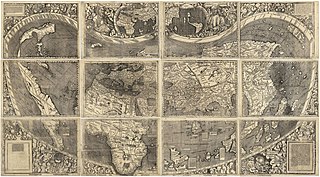
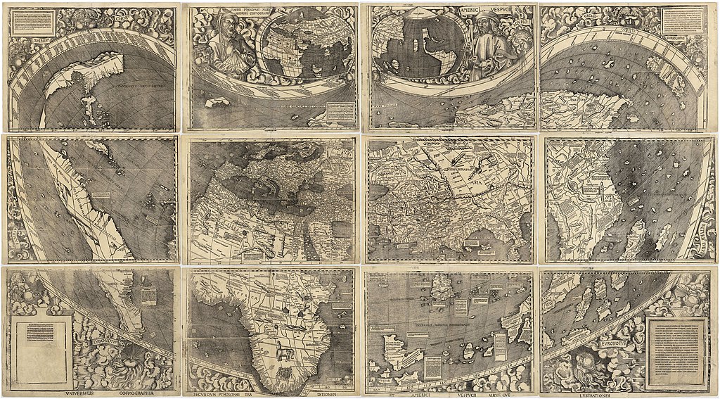
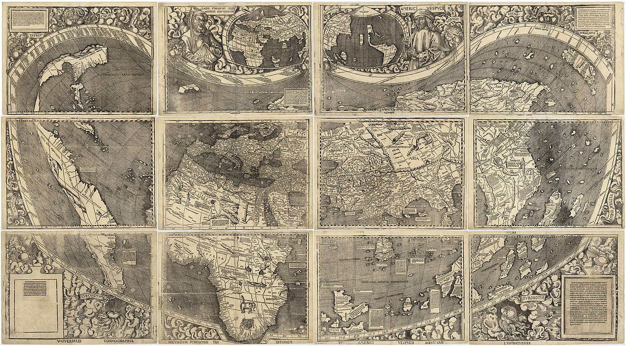
English: Waldseemüller map from 1507 is the first map to include the name "America" and the first to depict the Americas as separate from Asia. There is only one surviving copy of the map, which was purchased by the Library of Congress in 2001 for $10 million.
Français : Le planisphère de Waldseemüller de 1507 est la première carte mentionnant le nom "America" et la première à décrire les Amériques séparées de l'Asie. Il ne reste plus qu'une seule copie du planisphère encore existante à ce jour, acquise par la bibliothèque du Congrès en 2001 pour la somme de 10 millions de dollars. |
| 日期 | |
| 来源 | https://www.loc.gov/resource/g3200.ct000725 |
| 作者 | |
| 其他版本 |
|


评价
[编辑]
|

许可协议
[编辑]
|
本作品在其来源国以及其他著作权期限是作者逝世后100年或以下的国家和地区属于公有领域。 | |
| 本文件已被确认为免除已知的著作权法限制(包括所有相关权利)。 | |
文件历史
点击某个日期/时间查看对应时刻的文件。
| 日期/时间 | 缩略图 | 大小 | 用户 | 备注 | |
|---|---|---|---|---|---|
| 当前 | 2008年10月27日 (一) 17:37 | | 13,708 × 7,590(19.65 MB) | Jackaranga(留言 | 贡献) | {{Information |Description={{en|1=waldseemuller map, full page from http://memory.loc.gov/cgi-bin/map_item.pl?data=/home/www/data/gmd/gmd3/g3200/g3200/ct000725.jp2&style=gmd&itemLink=r?ammem/gmd:@field(NUMBER+@band(g3200+ct000725))&title=Universalis%20cos |
您不可以覆盖此文件。
文件用途
以下27个页面使用本文件:
- Waldseemüller map
- User:AMHQ/Favorites
- User:Yann/Featured images/2019-2023
- User:Yann/Featured pictures by others
- User:Yann/Valued images/2017-2019
- User:Yann/Valued images by others
- Commons:Featured picture candidates/File:Waldseemuller map 2.jpg
- Commons:Featured picture candidates/Log/January 2019
- Commons:Featured pictures/Non-photographic media/Maps
- Commons:Featured pictures/chronological/2019-A
- Commons:Picture of the Year/2019/Candidates
- Commons:Picture of the Year/2019/R1/Gallery/2019-A
- Commons:Picture of the Year/2019/R1/Gallery/ALL
- Commons:Picture of the Year/2019/R1/Gallery/M01
- Commons:Picture of the Year/2019/R1/Gallery/Maps
- Commons:Picture of the Year/2019/R1/v/Waldseemuller map 2.jpg
- Commons:Valued image candidates/Waldseemuller map 2.jpg
- File:1507 Waldseemüller world map - Taprobana detail.jpg
- File:Map of the Waldseemüller globe in nearly rectangular projection.jpg
- File:Map of the Waldseemüller globe in nearly rectangular projection 2.jpg
- File:TERRA·VLTERIꝰ·INCOGNITA.jpg
- File:Waldseemuller map, complete.jpg
- File:Waldseemuller map, complete 100%.jpg
- File:Waldseemuller map.jpg
- File:Waldseemuller map Caribbean.jpg
- File:Waldseemüller Globensegmente Cim107-2.jpg
- Category:Waldseemüller map
全域文件用途
以下其他wiki使用此文件:
- af.wikipedia.org上的用途
- als.wikipedia.org上的用途
- ar.wikipedia.org上的用途
- الأمريكتان
- العصر الحديث
- خريطة فالدسيمولير
- استكشاف أمريكا الشمالية
- بوابة:جغرافيا/صورة مختارة/أرشيف
- ويكيبيديا:صور مختارة/رسومات وجداول وخرائط/خرائط
- ويكيبيديا:ترشيحات الصور المختارة/خريطة فالدسيمولير
- ويكيبيديا:صورة اليوم المختارة/مارس 2018
- قالب:صورة اليوم المختارة/2018-03-24
- بوابة:جغرافيا/صورة مختارة/13
- ويكيبيديا:صورة اليوم المختارة/سبتمبر 2022
- قالب:صورة اليوم المختارة/2022-09-03
- ast.wikipedia.org上的用途
- az.wikipedia.org上的用途
- bg.wikipedia.org上的用途
- bn.wikipedia.org上的用途
- br.wikipedia.org上的用途
- ca.wikipedia.org上的用途
- cs.wikipedia.org上的用途
- cy.wikipedia.org上的用途
- da.wikipedia.org上的用途
- de.wikipedia.org上的用途
- 16. Jahrhundert
- Christoph Kolumbus
- Neuzeit
- Martin Waldseemüller
- Weltkarte
- Benutzer:Mondamo/karten
- Liste historischer Weltkarten
- UNESCO-Kultur- und -Naturerbe
- Benutzer:GiFontenelle/Entwurf/Q131454, bibliothek
- Benutzer:Muhali/Waldseemüller Karte
- Benutzer:Springen/Waldseemüller-Karte
- Benutzer:Cupkake4Yoshi/History of geography
- Cosmographiae Introductio
- el.wikipedia.org上的用途
- en.wikipedia.org上的用途
查看此文件的更多全域用途。