File:Wales Administrative Map 2009.png
跳至導覽
跳至搜尋
預覽大小:380 × 599 像素。 其他解析度:152 × 240 像素 | 304 × 480 像素 | 487 × 768 像素 | 649 × 1,024 像素 | 2,150 × 3,389 像素。
原始檔案 (2,150 × 3,389 像素,檔案大小:1.09 MB,MIME 類型:image/png)
說明
說明
添加單行說明來描述出檔案所代表的內容
摘要
[編輯]
| 描述 |
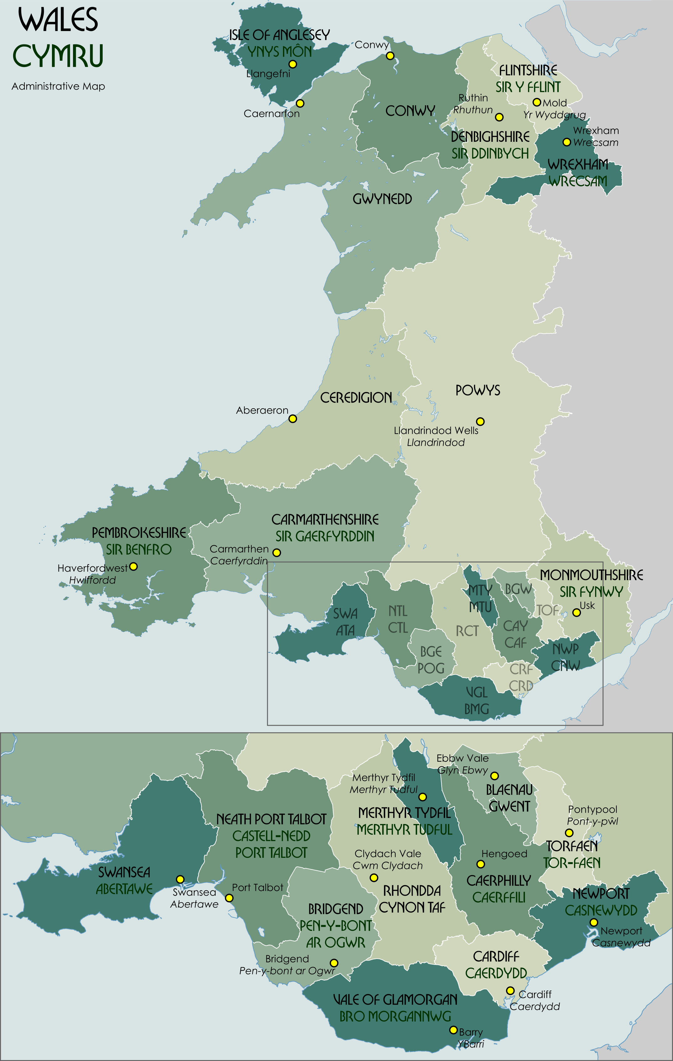
English: Administrative map showing the unitary authorities of Wales and their administrative HQs. |
| 日期 | |
| 來源 | 自己的作品 |
| 作者 | XrysD |
Code for clickable map
[編輯]

授權條款
[編輯]
我,本作品的著作權持有者,決定用以下授權條款發佈本作品:

|
已授權您依據自由軟體基金會發行的無固定段落、封面文字和封底文字GNU自由文件授權條款1.2版或任意後續版本,對本檔進行複製、傳播和/或修改。該協議的副本列在GNU自由文件授權條款中。 |
檔案歷史
點選日期/時間以檢視該時間的檔案版本。
| 日期/時間 | 縮圖 | 尺寸 | 用戶 | 備註 | |
|---|---|---|---|---|---|
| 目前 | 2021年11月30日 (二) 12:33 | | 2,150 × 3,389(1.09 MB) | XrysD(對話 | 貢獻) | Correct version |
| 2021年11月30日 (二) 12:28 |  | 2,150 × 3,389(951 KB) | XrysD(對話 | 貢獻) | Fixed typo (Gaerfyddin->Caerfyrddin for the city) | |
| 2016年5月25日 (三) 17:43 |  | 2,150 × 3,389(1.18 MB) | XrysD(對話 | 貢獻) | Change Monmouthshire admin HQ from Cwmbran to Usk. | |
| 2012年9月26日 (三) 18:22 |  | 2,150 × 3,389(1.16 MB) | XrysD(對話 | 貢獻) | Fixed typo (Gaerfyddin->Gaerfyrddin) | |
| 2012年9月26日 (三) 11:51 |  | 2,150 × 3,389(1.14 MB) | Citypeek(對話 | 貢獻) | removal watermark | |
| 2010年9月3日 (五) 22:18 |  | 2,150 × 3,389(1.17 MB) | XrysD(對話 | 貢獻) | Fixed order of NTL/CTL ISO 3166-2 code. | |
| 2010年9月3日 (五) 22:09 |  | 2,150 × 3,389(1.17 MB) | XrysD(對話 | 貢獻) | Fixed Torfaen so that English/Welsh names in correct order. Minor change to title font size. | |
| 2010年9月3日 (五) 21:54 |  | 2,150 × 3,389(1.17 MB) | XrysD(對話 | 貢獻) | Changed Celtic Hand font to Bullion to improve legibility. Rationalised names so that format is English over Welsh for UA and admin centres. Changed Welsh UA names to green colour adopting system used for railway signs in Wales. | |
| 2010年1月16日 (六) 11:18 |  | 2,150 × 3,389(1.12 MB) | XrysD(對話 | 貢獻) | Made spelling corrections and colour changes | |
| 2010年1月16日 (六) 10:03 |  | 2,150 × 3,389(1.13 MB) | XrysD(對話 | 貢獻) | Removed Cardiganshire as alternative name for Ceredigion. Added sig. Moved label for Swansea slightly. |
無法覆蓋此檔案。
檔案用途
下列2個頁面有用到此檔案:
全域檔案使用狀況
以下其他 wiki 使用了這個檔案:
- af.wikipedia.org 的使用狀況
- ar.wikipedia.org 的使用狀況
- ast.wikipedia.org 的使用狀況
- bxr.wikipedia.org 的使用狀況
- ca.wikipedia.org 的使用狀況
- cy.wikipedia.org 的使用狀況
- en.wikipedia.org 的使用狀況
- es.wikipedia.org 的使用狀況
- eu.wikipedia.org 的使用狀況
- fa.wikipedia.org 的使用狀況
- fi.wikipedia.org 的使用狀況
- fr.wikipedia.org 的使用狀況
- fr.wiktionary.org 的使用狀況
- ga.wikipedia.org 的使用狀況
- gd.wikipedia.org 的使用狀況
- id.wikipedia.org 的使用狀況
- is.wikipedia.org 的使用狀況
- it.wikipedia.org 的使用狀況
- ja.wikipedia.org 的使用狀況
- kn.wikipedia.org 的使用狀況
- ko.wikipedia.org 的使用狀況
- lld.wikipedia.org 的使用狀況
- mn.wikipedia.org 的使用狀況
- mt.wikipedia.org 的使用狀況
- mzn.wikipedia.org 的使用狀況
- nl.wikipedia.org 的使用狀況
- no.wikipedia.org 的使用狀況
- ps.wikipedia.org 的使用狀況
- sco.wikipedia.org 的使用狀況
- simple.wikipedia.org 的使用狀況
- sr.wikipedia.org 的使用狀況
- test2.wikipedia.org 的使用狀況
- tr.wikipedia.org 的使用狀況
檢視此檔案的更多全域使用狀況。