File:Wallis island - Hahake and lagoon - rotated and cropped (NASA ISS002-E-7405).jpg
Jump to navigation
Jump to search

Size of this preview: 322 × 599 pixels. Other resolutions: 129 × 240 pixels | 258 × 480 pixels | 413 × 768 pixels | 550 × 1,024 pixels | 1,644 × 3,058 pixels.
Original file (1,644 × 3,058 pixels, file size: 2.2 MB, MIME type: image/jpeg)
Captions
Captions
Add a one-line explanation of what this file represents
Summary
[edit]| Description |
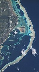
Français : Photo satellite de l'île de Wallis, montrant une partie du district de Hahake et du lagon avec les îlots Luaniva, Fugalei (en dessous), Nukuhione (petit en haut à droite) et Nukuhifala (en dessous, au niveau de la barrière de corail) . En haut, l'aéroport de Hihifo est visible. Image retouchée (pivotée et rognée)
English: Satellite picture of Wallis island (Hahake district and the lagoon with the following islets: Luaniva, Fugalei, Nukuhione, Nukuhifala). The Hihifo airstrip is also visible in the upper left corner. Cropped and rotated picture |
| Date | |
| Source | https://eol.jsc.nasa.gov/DatabaseImages/ESC/large/ISS002/ISS002-E-7405.JPG |
| Author | NASA |
| Other versions |
_(cropped).jpg)
.jpg&action=edit§ion=1)
| This is a retouched picture, which means that it has been digitally altered from its original version. Modifications: rotated, cropped. Modifications made by Skimel. The original can be found here: https://eol.jsc.nasa.gov/DatabaseImages/ESC/large/ISS002/ISS002-E-7405.JPG.
|
Licensing
[edit].jpg&action=edit§ion=2)
| This file is in the public domain in the United States because it was solely created by NASA. NASA copyright policy states that "NASA material is not protected by copyright unless noted". (See Template:PD-USGov, NASA copyright policy page or JPL Image Use Policy.) | ||
 |
Warnings:
|
File history
Click on a date/time to view the file as it appeared at that time.
| Date/Time | Thumbnail | Dimensions | User | Comment | |
|---|---|---|---|---|---|
| current | 10:11, 15 August 2017 | | 1,644 × 3,058 (2.2 MB) | Skimel (talk | contribs) | User created page with UploadWizard |
You cannot overwrite this file.
File usage on Commons
The following 2 pages use this file:
File usage on other wikis
The following other wikis use this file:
- Usage on fr.wikipedia.org
.jpg&oldid=910709435)