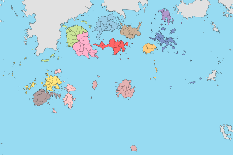
File:Wando County Legal-status village produced with March 2017 information provided by National Geographic Information Institute.png
From Wikimedia Commons, the free media repository
Jump to navigation
Jump to search

Size of this preview: 800 × 534 pixels. Other resolutions: 320 × 213 pixels | 640 × 427 pixels | 1,024 × 683 pixels | 1,280 × 854 pixels | 2,560 × 1,708 pixels | 5,904 × 3,938 pixels.
Original file (5,904 × 3,938 pixels, file size: 364 KB, MIME type: image/png)
File information
Structured data
Captions
Captions
Add a one-line explanation of what this file represents
국토지리정보원에서 제공한 2017년 3월판 완도군 법정리 행정구역
Summary[edit]
| DescriptionWando County Legal-status village produced with March 2017 information provided by National Geographic Information Institute.png |
한국어: 국토지리정보원에서 제공한 2017년 3월판 완도군 법정리 행정구역 |
| Date | |
| Source | 완도군 법정리 백지도 |
| Author | 지도제작부 |
Licensing[edit]
This file is licensed under the Creative Commons Attribution 4.0 International license.
- You are free:
- to share – to copy, distribute and transmit the work
- to remix – to adapt the work
- Under the following conditions:
- attribution – You must give appropriate credit, provide a link to the license, and indicate if changes were made. You may do so in any reasonable manner, but not in any way that suggests the licensor endorses you or your use.
File history
Click on a date/time to view the file as it appeared at that time.
| Date/Time | Thumbnail | Dimensions | User | Comment | |
|---|---|---|---|---|---|
| current | 12:04, 16 August 2020 |  | 5,904 × 3,938 (364 KB) | 고려 (talk | contribs) | 색 수정 |
| 11:52, 16 August 2020 |  | 5,904 × 3,938 (367 KB) | 고려 (talk | contribs) | Uploaded a work by [https://arca.live/u/@%EC%A7%80%EB%8F%84%EC%A0%9C%EC%9E%91%EB%B6%80 지도제작부] from [https://arca.live/b/city/6216688 완도군 법정리 백지도] with UploadWizard |
You cannot overwrite this file.
File usage on Commons
There are no pages that use this file.
File usage on other wikis
The following other wikis use this file:
- Usage on ko.wikipedia.org
- Usage on sv.wikipedia.org
- Usage on th.wikipedia.org
Metadata
This file contains additional information such as Exif metadata which may have been added by the digital camera, scanner, or software program used to create or digitize it. If the file has been modified from its original state, some details such as the timestamp may not fully reflect those of the original file. The timestamp is only as accurate as the clock in the camera, and it may be completely wrong.
| Horizontal resolution | 500 dpi |
|---|---|
| Vertical resolution | 500 dpi |
| Color space | sRGB |
| Image width | 5,904 px |
| Image height | 3,938 px |
| Software used | Adobe Photoshop CC 2017 (Windows) |
| Date and time of digitizing | 01:26, 17 August 2020 |
| File change date and time | 06:04, 17 August 2020 |
| Date metadata was last modified | 06:04, 17 August 2020 |
| Unique ID of original document | xmp.did:429fd030-9c55-5148-b336-427284b6896b |
Hidden category: