File:Washington SP petroglyph Dec2011 n28.jpg
![File:Washington SP petroglyph Dec2011 n28.jpg](https://upload.wikimedia.org/wikipedia/commons/thumb/8/84/Washington_SP_petroglyph_Dec2011_n28.jpg/450px-Washington_SP_petroglyph_Dec2011_n28.jpg?20120101215642)
Original file (2,736 × 3,648 pixels, file size: 4.12 MB, MIME type: image/jpeg)
Captions
Captions
Summary
[edit]Camera location | 38° 04′ 40.76″ N, 90° 41′ 02.42″ W ![]() ![]() | View this and other nearby images on: OpenStreetMap | ![]() |
---|
DescriptionWashington SP petroglyph Dec2011 n28.jpg |
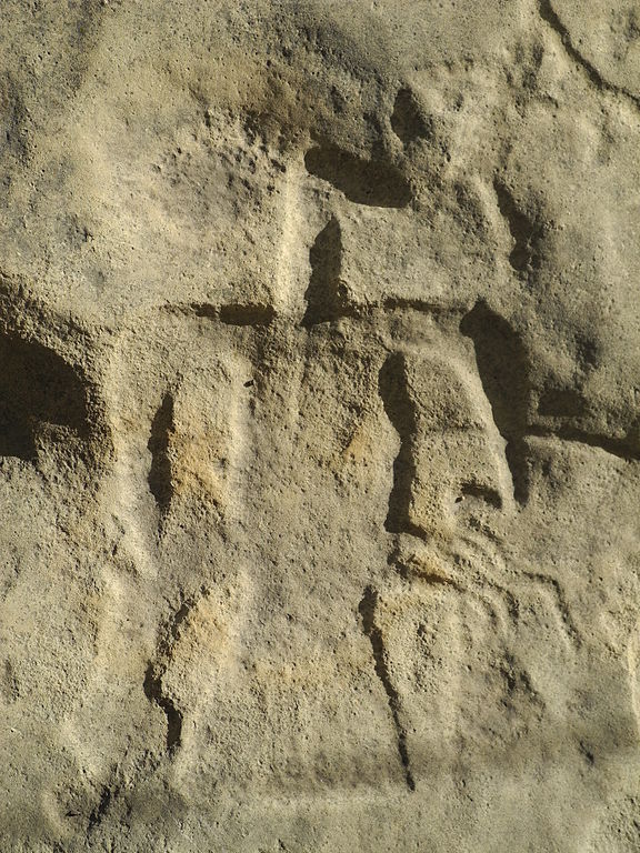
English: A petroglyph at Washington State Park in Missouri dated to approximately 1000 C.E. This image is interpreted as "sacred eagle and shamen".[1] The figure in the image is approximately 10-12 inches (25-30 cm) tall.
|
||
Date | |||
Source | Own work | ||
Author | Kbh3rd |
Licensing
[edit]![w:en:Creative Commons](https://upload.wikimedia.org/wikipedia/commons/thumb/7/79/CC_some_rights_reserved.svg/90px-CC_some_rights_reserved.svg.png)
![attribution](https://upload.wikimedia.org/wikipedia/commons/thumb/1/11/Cc-by_new_white.svg/24px-Cc-by_new_white.svg.png)
![share alike](https://upload.wikimedia.org/wikipedia/commons/thumb/d/df/Cc-sa_white.svg/24px-Cc-sa_white.svg.png)
- You are free:
- to share – to copy, distribute and transmit the work
- to remix – to adapt the work
- Under the following conditions:
- attribution – You must give appropriate credit, provide a link to the license, and indicate if changes were made. You may do so in any reasonable manner, but not in any way that suggests the licensor endorses you or your use.
- share alike – If you remix, transform, or build upon the material, you must distribute your contributions under the same or compatible license as the original.
File history
Click on a date/time to view the file as it appeared at that time.
Date/Time | Thumbnail | Dimensions | User | Comment | |
---|---|---|---|---|---|
current | 21:56, 1 January 2012 | ![]() | 2,736 × 3,648 (4.12 MB) | Kbh3rd (talk | contribs) |
You cannot overwrite this file.
File usage on Commons
The following page uses this file:
File usage on other wikis
The following other wikis use this file:
- Usage on de.wikipedia.org
- Usage on en.wikipedia.org
- Usage on www.wikidata.org
Metadata
This file contains additional information such as Exif metadata which may have been added by the digital camera, scanner, or software program used to create or digitize it. If the file has been modified from its original state, some details such as the timestamp may not fully reflect those of the original file. The timestamp is only as accurate as the clock in the camera, and it may be completely wrong.
Camera manufacturer | NIKON |
---|---|
Camera model | COOLPIX P7000 |
Exposure time | 1/910 sec (0.0010989010989011) |
F-number | f/4 |
ISO speed rating | 100 |
Date and time of data generation | 13:56, 31 December 2011 |
Lens focal length | 14.5 mm |
Latitude | 38° 4′ 40.76″ N |
Longitude | 90° 41′ 2.42″ W |
Altitude | 250 meters above sea level |
City shown | Fertile |
Credit/Provider | Wikipedia editor Kbh3rd |
Copyright holder | Copyright 2011 Kbh3rd |
Image title | Indian petroglyphs in Washington S.P. |
Orientation | Normal |
Horizontal resolution | 300 dpi |
Vertical resolution | 300 dpi |
Software used | COOLPIX P7000V1.0 |
File change date and time | 13:56, 31 December 2011 |
Y and C positioning | Co-sited |
Exposure Program | Normal program |
Exif version | 2.2 |
Date and time of digitizing | 13:56, 31 December 2011 |
Meaning of each component |
|
Image compression mode | 4 |
APEX exposure bias | 0 |
Maximum land aperture | 3 APEX (f/2.83) |
Metering mode | Pattern |
Light source | Unknown |
Flash | Flash did not fire, compulsory flash suppression |
Supported Flashpix version | 1 |
Color space | sRGB |
File source | Digital still camera |
Scene type | A directly photographed image |
Custom image processing | Normal process |
Exposure mode | Auto exposure |
White balance | Auto white balance |
Digital zoom ratio | 0 |
Focal length in 35 mm film | 68 mm |
Scene capture type | Standard |
Scene control | None |
Contrast | Normal |
Saturation | Normal |
Sharpness | Normal |
Subject distance range | Unknown |
GPS time (atomic clock) | 19:56 |
Reference for direction of image | True direction |
Direction of image | 0 |
Geodetic survey data used | WGS-84 |
GPS date | 31 December 2011 |
GPS tag version | 0.0.2.2 |
IIM version | 4 |
Special instructions | Lat 38.077989919, Lon -90.684004873 - Bearing: 0 - Altitude: 250m |
Sublocation of city shown | Washington State Park |
Province or state shown | Missouri |
Country shown | US |