File:Wattasid Morocco EN.PNG
Jump to navigation
Jump to search

Size of this preview: 514 × 599 pixels. Other resolutions: 206 × 240 pixels | 636 × 741 pixels.
Original file (636 × 741 pixels, file size: 37 KB, MIME type: image/png)
Captions
Captions
Add a one-line explanation of what this file represents
Summary
[edit]
| Description |
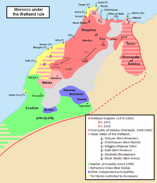
English: Geopolitical map of Morocco under Wattasid rule.
Inspired from a map in the book "Le Maroc dans les premières années du XVIe siècle : Tableau géographique d'après Léon L'Africain", par Louis Massignon, dans "Mémoires de la Société Historique Algérienne I", Éd. Adolphe Jourdan (1906). (Num. OCLC 490558897) (in French). 1472 borders are the ones inherited from the Merinids. |
| Source | Own work |
| Author | Omar-Toons |
| Other versions | File:Marruecos1500-1515-Col.PNG |
Licensing
[edit]
I, the copyright holder of this work, hereby publish it under the following license:
This file is licensed under the Creative Commons Attribution 3.0 Unported license.
- You are free:
- to share – to copy, distribute and transmit the work
- to remix – to adapt the work
- Under the following conditions:
- attribution – You must give appropriate credit, provide a link to the license, and indicate if changes were made. You may do so in any reasonable manner, but not in any way that suggests the licensor endorses you or your use.
File history
Click on a date/time to view the file as it appeared at that time.
| Date/Time | Thumbnail | Dimensions | User | Comment | |
|---|---|---|---|---|---|
| current | 00:23, 22 March 2012 | | 636 × 741 (37 KB) | Omar-Toons (talk | contribs) | Hintata allied to Wattasids during the first quarter of the XVIth c. |
| 01:36, 6 August 2011 |  | 636 × 741 (38 KB) | Omar-Toons (talk | contribs) | minor edit (Esp->Sp) | |
| 01:33, 6 August 2011 |  | 636 × 741 (38 KB) | Omar-Toons (talk | contribs) | {{Information |Description ={{en|1=Geopolitical map of Morocco under Wattasid rule. Inspired from a map in the book "Le Maroc dans les premières années du XVIe siècle : Tableau géographique d'après Léon L'Africain", par Louis Massignon, dans "M� |
You cannot overwrite this file.
File usage on Commons
There are no pages that use this file.
File usage on other wikis
The following other wikis use this file:
- Usage on ar.wikipedia.org
- Usage on ru.wikipedia.org