File:West Midland Metro near Kenrick Park (crop), geograph 6264433 by Alan Murray Rust.jpg
Jump to navigation
Jump to search

Size of this preview: 800 × 540 pixels. Other resolutions: 320 × 216 pixels | 640 × 432 pixels | 860 × 580 pixels.
Original file (860 × 580 pixels, file size: 606 KB, MIME type: image/jpeg)
Captions
Captions
Add a one-line explanation of what this file represents
Summary[edit]
,_geograph_6264433_by_Alan_Murray_Rust.jpg&action=edit§ion=1)
| Description |
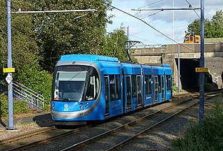
English: West Midland Metro near Kenrick Park
Heading towards Birmingham, about to pass under the M5. |
| Date | |
| Source |
This file was derived from: West Midland Metro near Kenrick Park, geograph 6264433 by Alan Murray Rust.jpg |
| Author | Alan Murray Rust |
| Permission (Reusing this file) |
This file is licensed under the Creative Commons Attribution-Share Alike 2.0 Generic license. Attribution: Alan Murray Rust
|
| Attribution (required by the license) | Alan Murray Rust / West Midland Metro near Kenrick Park / |
File history
Click on a date/time to view the file as it appeared at that time.
| Date/Time | Thumbnail | Dimensions | User | Comment | |
|---|---|---|---|---|---|
| current | 00:56, 23 February 2022 | | 860 × 580 (606 KB) | G-13114 (talk | contribs) | {{Information |description={{en|1=West Midland Metro near Kenrick Park Heading towards Birmingham, about to pass under the M5.}} |date=2019-09-05 |source= {{Derived from|West Midland Metro near Kenrick Park, geograph 6264433 by Alan Murray Rust.jpg}} |author= Alan Murray Rust |permission= {{cc-by-sa-2.0|Alan Murray Rust}} |other_versions= |other fields= {{Credit line |Author = Alan Murray Rust |Other = ''West Midland Metro near Kenrick Park'' |License = CC-BY-SA-2.0 }}}} [[Category... |
You cannot overwrite this file.
File usage on Commons
The following page uses this file:
File usage on other wikis
The following other wikis use this file:
- Usage on de.wikipedia.org
,_geograph_6264433_by_Alan_Murray_Rust.jpg&oldid=705977245)