File:West view of Gosaukamm (2009).jpg
Jump to navigation
Jump to search

Size of this preview: 799 × 265 pixels. Other resolutions: 320 × 106 pixels | 640 × 212 pixels | 1,024 × 340 pixels | 1,280 × 425 pixels | 2,560 × 850 pixels | 22,738 × 7,546 pixels.
Original file (22,738 × 7,546 pixels, file size: 67.16 MB, MIME type: image/jpeg)
Captions
Captions
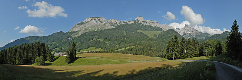
West view of Gosaukamm
| Warning | The original file is very high-resolution. It might not load properly or could cause your browser to freeze when opened at full size. |
|---|
.jpg&flash=no)
Summary
[edit].jpg&action=edit§ion=1)
| Description |
English: West view of Gosaukamm with Bischofsmütze seen from Kopfberg, Annaberg-Lungötz, Austria. Panorama of 41 images. The picture contains notes created with ImageAnnotator, please install it first if you want to see the labels. – I thank Mike Ramsauer of Gosaukamm.at who helped me to identify several peaks.
Deutsch: Westseite des Gosaukamms mit der Bischofsmütze, ein Gebirgsstock des Dachsteingebirges. Aufnahme auf dem Kopfberg in Annaberg-Lungötz, Salzburger Land. Panorama aus 41 Fotos. Das Bild enthält mit ImageAnnotator erstellte Notizen, die erst nach Installation von ImageAnnotator sichtbar sind. – Ich danke Mike Ramsauer von Gosaukamm.at, der mir bei der Identifizierung mehrerer Gipfel half. |
| Date | |
| Source | Own work |
| Author | Jochen Teufel |
| Camera location | | View this and other nearby images on: OpenStreetMap |
|---|
.jpg¶ms=047.509333_N_0013.453500_E_globe:Earth_type:camera_alt:977_source:exif_&language=en)
Licensing
[edit].jpg&action=edit§ion=2)
I, the copyright holder of this work, hereby publish it under the following licenses:
This file is licensed under the Creative Commons Attribution-Share Alike 3.0 Unported license.
- You are free:
- to share – to copy, distribute and transmit the work
- to remix – to adapt the work
- Under the following conditions:
- attribution – You must give appropriate credit, provide a link to the license, and indicate if changes were made. You may do so in any reasonable manner, but not in any way that suggests the licensor endorses you or your use.
- share alike – If you remix, transform, or build upon the material, you must distribute your contributions under the same or compatible license as the original.

|
Permission is granted to copy, distribute and/or modify this document under the terms of the GNU Free Documentation License, Version 1.2 or any later version published by the Free Software Foundation; with no Invariant Sections, no Front-Cover Texts, and no Back-Cover Texts. A copy of the license is included in the section entitled GNU Free Documentation License. |
You may select the license of your choice.
| Annotations | This image is annotated: View the annotations at Commons |
.jpg)
This image has been assessed using the Quality image guidelines and is considered a Quality image.
|
File history
Click on a date/time to view the file as it appeared at that time.
| Date/Time | Thumbnail | Dimensions | User | Comment | |
|---|---|---|---|---|---|
| current | 21:45, 12 August 2009 | 22,738 × 7,546 (67.16 MB) | Iotatau (talk | contribs) | {{Information |Description={{en|1=West view of Gosaukamm with Bischofsmütze seen from Kopfberg, Annaberg-Lungötz, Austria. Panorama of 41 images. The picture contains notes created with [[Help:Gadget-ImageAnnota |
You cannot overwrite this file.
File usage on Commons
The following 4 pages use this file:
File usage on other wikis
The following other wikis use this file:
- Usage on de.wikipedia.org
- Usage on fr.wikipedia.org
.jpg&oldid=806488345)