File:Western Cape rail network map.svg
Jump to navigation
Jump to search

Size of this PNG preview of this SVG file: 753 × 599 pixels. Other resolutions: 302 × 240 pixels | 603 × 480 pixels | 965 × 768 pixels | 1,280 × 1,019 pixels | 2,560 × 2,038 pixels | 868 × 691 pixels.
Original file (SVG file, nominally 868 × 691 pixels, file size: 95 KB)
Captions
Captions
Add a one-line explanation of what this file represents
| Description |
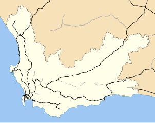
English: Map of the Western Cape with railway lines. Black lines are active; grey lines are disused; the dotted grey line is abandoned and lifted. |
| Date | |
| Source | Geodata from OpenStreetMap |
| Author | Adrian Frith; OpenStreetMap contributors |
| Permission (Reusing this file) |
I, the copyright holder of this work, hereby publish it under the following licenses: This file is licensed under the Creative Commons Attribution-Share Alike 4.0 International and 3.0 Unported license.
This file is licensed under the Creative Commons Attribution-Share Alike 2.0 Generic license.
You may select the license of your choice. |
File history
Click on a date/time to view the file as it appeared at that time.
| Date/Time | Thumbnail | Dimensions | User | Comment | |
|---|---|---|---|---|---|
| current | 20:15, 24 December 2012 | | 868 × 691 (95 KB) | Htonl (talk | contribs) | restore lifted line |
| 20:06, 24 December 2012 |  | 868 × 691 (94 KB) | Htonl (talk | contribs) | small fixes | |
| 16:09, 24 December 2012 |  | 868 × 691 (116 KB) | Htonl (talk | contribs) | colours, lines, sizes | |
| 14:27, 23 June 2012 |  | 849 × 676 (367 KB) | Htonl (talk | contribs) | change style | |
| 02:21, 17 June 2011 |  | 849 × 676 (466 KB) | Htonl (talk | contribs) | {{Information |Description ={{en|1=Map of the Western Cape with railway lines. Black lines are active; grey lines are disused; the dotted grey line is abandoned and lifted.}} |Source =Geodata from [[w:en:OpenStreetMap|OpenStr |
You cannot overwrite this file.
File usage on Commons
The following page uses this file:
- File:Railway map of the Western Cape.svg (file redirect)
File usage on other wikis
The following other wikis use this file:
- Usage on en.wikipedia.org