File:Western Europe.ogv
Przejdź do nawigacji
Przejdź do wyszukiwania
Wielkość pliku podglądu JPG dla pliku OGG: 800 × 533 pikseli Inne rozdzielczości: 320 × 213 pikseli | 640 × 427 pikseli | 840 × 560 pikseli.
Rozmiar pierwotny (plik wideo Ogg Theora, długość 30 s, rozdzielczość 840×560, 2,58 Mbps, rozmiar pliku: 9,08 MB)
Podpisy
Podpisy
Dodaj jednolinijkowe objaśnienie tego, co ten plik pokazuje
Western Europe
Opis
[edytuj]| Opis |
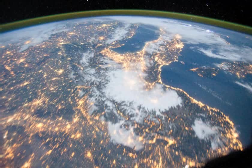
English: This video was taken by the crew of Expedition 29 on board the International Space Station. The sequence of shots was taken October 15, 2011 from 00:47:28 to 01:02:56 GMT, on a pass beginning over the North Atlantic Ocean, east of the Island of Newfoundland to the northern part of the Red Sea, over the Gulf of Suez and the Sinai Peninsula. At the beginning of the video, the Aurora Borealis can be seen in the far left along with clouds over the North Atlantic Ocean. Tracking south-east, the first view of lights is from the United Kingdom (Ireland, up-track from the UK, is under cloud), with cities like Liverpool and London showing up nicely. Across the English Channel, the cities of Brussels and Rotterdam (left) and Paris (brightly-lit city west of Brussels) all stand out through a network of smaller cities in Western Europe. The pass continues over the snow-covered Alps and to the Italian Peninsula, where lightning storms cover the southern half of the peninsula. The ISS then tracks over the Mediterranean Sea, with Greece to the left of track, northern Africa right of track, and the island of Crete. Finally, the pass finishes near the Nile River Delta and the Red Sea. |
| Data | |
| Źródło | The Gateway to Astronaut Photography of Earth |
| Autor | ISS Expedition 29 crew |
Licencja
[edytuj]| Ten plik jest w domenie publicznej ponieważ został stworzony przez NASA. Polityka praw autorskich NASA stwierdza, że „materiały NASA nie są chronione prawami autorskimi, chyba że zapisano inaczej”. (NASA copyright policy lub JPL Image Use Policy). | ||
 |
Uwaga:
|
| Ten plik został wybrany jako multimedia dnia dla 22 czerwca 2015. Został on podpisany następująco:
English: The flight of Expedition 29 on board the International Space Station during October 15, 2011 from 00:47:28 to 01:02:56 GMT, beginning over the North Atlantic Ocean and finally, the pass finishes near the Nile River Delta and the Red Sea.
Other languages
Čeština: Let 29. expedice na palubě Mezinárodní vesmírné stanice ISS dne 15. října, 2011 v období 00:47:28 do 01:02:56 GMT, začátek nad severním Atlantickým oceánem, ukončení záběrů nad deltou Nilu a Rudým mořem. English: The flight of Expedition 29 on board the International Space Station during October 15, 2011 from 00:47:28 to 01:02:56 GMT, beginning over the North Atlantic Ocean and finally, the pass finishes near the Nile River Delta and the Red Sea. 中文(简体):国际空间站第29长期考察组拍摄的地球景色
|
Historia pliku
Kliknij na odpowiedniej dacie/czasie, aby zobaczyć wersję pliku z tamtego okresu.
| Data/czas | Miniatura | Wymiary | Użytkownik | Opis | |
|---|---|---|---|---|---|
| aktualny | 13:19, 1 lis 2011 | 30 s, 840 × 560 (9,08 MB) | Originalwana (dyskusja | edycje) | {{Information |Description ={{en|1=This video was taken by the crew of Expedition 29 on board the International Space Station. The sequence of shots was taken October 15, 2011 from 00:47:28 to 01:02:56 GMT, on a pass |
Nie możesz nadpisać tego pliku.
Lokalne wykorzystanie pliku
Następujące strony korzystają z tego pliku:
- Template:Motd/2015-06
- Template:Motd/2015-06-22
- Template:Motd/2015-06-22 (cs)
- Template:Motd/2015-06-22 (en)
- Template:Motd/2015-06-22 (zh-hans)
- Template:Potd/2015-06
- Category:Christianity in Western Europe
- Category:Geography of Western Europe
- Category:Maps of Western Europe
- Category:Views of Western Europe
- Category:Western Europe
Status konwersji
Zaktualizuj status konwersjiGlobalne wykorzystanie pliku
Ten plik jest wykorzystywany także w innych projektach wiki:
- Wykorzystanie na bn.wikipedia.org
- Wykorzystanie na de.wikipedia.org
- Wykorzystanie na de.wiktionary.org
- Wykorzystanie na el.wikipedia.org
- Wykorzystanie na en.wikipedia.org
- Wykorzystanie na ext.wikipedia.org
- Wykorzystanie na fo.wikipedia.org
- Wykorzystanie na hi.wikipedia.org
- Wykorzystanie na id.wikipedia.org
- Wykorzystanie na incubator.wikimedia.org
- Wykorzystanie na ko.wikipedia.org
- Wykorzystanie na la.wikipedia.org
- Wykorzystanie na ml.wikipedia.org
- Wykorzystanie na pa.wikipedia.org
- Wykorzystanie na pl.wikipedia.org
- Wykorzystanie na sl.wikipedia.org
- Wykorzystanie na so.wikipedia.org
- Wykorzystanie na sv.wikipedia.org
- Wykorzystanie na tt.wikipedia.org
- Wykorzystanie na uk.wikipedia.org
- Wykorzystanie na ur.wikipedia.org
- Wykorzystanie na www.wikidata.org