File:Western sahara moroccan walls topographic map-en.svg
Salta a la navegació
Salta a la cerca

Mida d'aquesta previsualització PNG del fitxer SVG: 711 × 600 píxels. Altres resolucions: 285 × 240 píxels | 569 × 480 píxels | 911 × 768 píxels | 1.214 × 1.024 píxels | 2.429 × 2.048 píxels | 1.187 × 1.001 píxels.
Fitxer original (fitxer SVG, nominalment 1.187 × 1.001 píxels, mida del fitxer: 1,06 Mo)
Llegendes
Llegendes
Afegeix una explicació d'una línia del que representa aquest fitxer
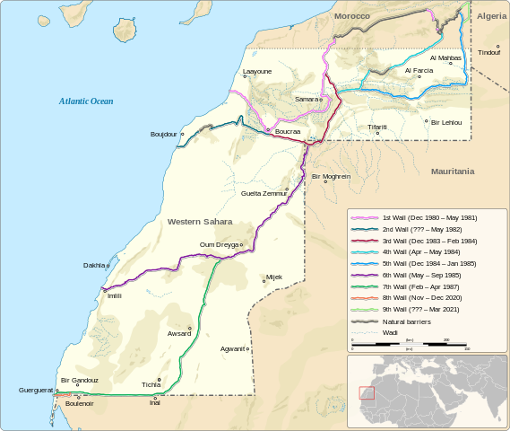
Location of the Moroccan sand walls in the Western Sahara
Resum
[modifica]| Descripció |
English: Location of the Moroccan sand walls in the Western Sahara
|
||||||||||||||
| Data | |||||||||||||||
| Font |
Own work based on: Information from:
|
||||||||||||||
| Autor | Goran_tek-en | ||||||||||||||
| Permís (Com reutilitzar aquest fitxer) |
This file is licensed under the Creative Commons Attribution-Share Alike 4.0 International license. Reconeixement: Goran_tek-en
|
||||||||||||||
| Altres versions |
|
||||||||||||||
| SVG genesis | Aquesta imatge vectorial ha estat creada amb Inkscape |
||||||||||||||


| Posició de l'objecte | | Aquesta i altres imatges properes a: OpenStreetMap |
|---|


Historial del fitxer
Cliqueu una data/hora per veure el fitxer tal com era aleshores.
| Data/hora | Miniatura | Dimensions | Usuari/a | Comentari | |
|---|---|---|---|---|---|
| actual | 12:32, 15 jul 2023 | | 1.187 × 1.001 (1,06 Mo) | Goran tek-en (discussió | contribucions) | Updated with wall 9 as requested by Antemister |
| 17:28, 25 set 2022 |  | 1.187 × 1.001 (1,05 Mo) | Goran tek-en (discussió | contribucions) | {{Information |description ={{en|Location of the Moroccan sand walls in the Western Sahara}} {{Institution |wikidata=Q510052}} {{Institution |wikidata=Q6250}} |date =2022-09-25 |source ={{Own based|Western sahara walls moroccan map-en.svg|Maps template-en.svg|BlankMap-World gray.svg|b1=M0tty|b2=Sting|b3=LivingShadow}} <br> Derived from; *[https://www.openstreetmap.org/#map=7/24.617/-13.513&layers=C OSM] Information from: *[https://googleearthcommunity.proboards.com/... |
No podeu sobreescriure aquest fitxer.
Ús del fitxer
Les 12 pàgines següents utilitzen aquest fitxer:
- User:Goran tek-en/Gallery/2022
- File:Western sahara territorial control 1976-1979 topographic map-en.svg
- File:Western sahara territorial control 1979-1981 topographic map-en.svg
- File:Western sahara territorial control topographic map-en.svg
- File:Western sahara walls moroccan.png
- File:Western sahara walls moroccan map-ar.svg
- File:Western sahara walls moroccan map-de.svg
- File:Western sahara walls moroccan map-en.svg
- File:Western sahara walls moroccan map-es.svg
- File:Western sahara walls moroccan map-eu.svg
- File:Western sahara walls moroccan map-fr.svg
- Template:Other versions/Western Sahara walls map
Ús global del fitxer
Utilització d'aquest fitxer en altres wikis:
- Utilització a ru.wikipedia.org