File:Wfm islay landsat.jpg
Salta a la navegació
Salta a la cerca
Mida d'aquesta previsualització: 800 × 593 píxels. Altres resolucions: 320 × 237 píxels | 640 × 474 píxels | 1.024 × 758 píxels | 1.280 × 948 píxels.
Fitxer original (1.280 × 948 píxels, mida del fitxer: 285 Ko, tipus MIME: image/jpeg)
Llegendes
Llegendes
Afegeix una explicació d'una línia del que representa aquest fitxer
Resum[modifica]
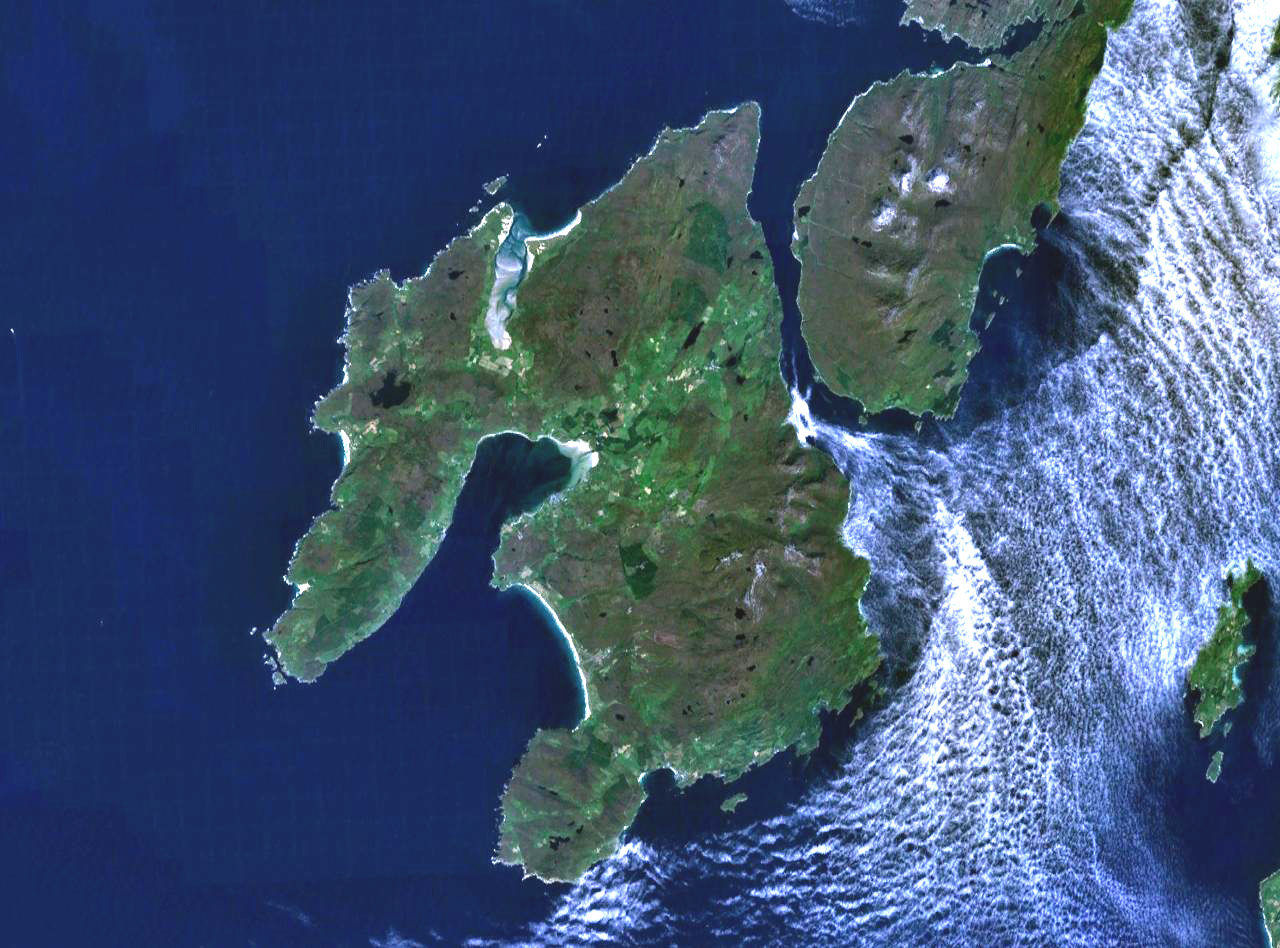
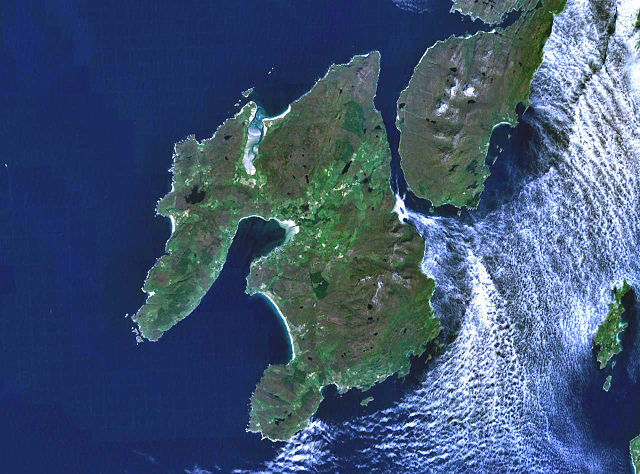
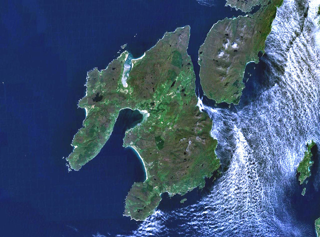
The island of Islay off the west coast of Scotland. The south part of the neighbouring island if Jura is visible to the northeast, and on the far east (right) of frame is the small island of Gigha.
Landsat 7 image, collected using NASA World Wind.

Llicència[modifica]
| This image is in the public domain because it is a screenshot from NASA’s globe software World Wind using a public domain layer, such as Blue Marble, MODIS, Landsat, SRTM, USGS or GLOBE.
|
 |
Historial del fitxer
Cliqueu una data/hora per veure el fitxer tal com era aleshores.
| Data/hora | Miniatura | Dimensions | Usuari/a | Comentari | |
|---|---|---|---|---|---|
| actual | 19:28, 4 ago 2005 | | 1.280 × 948 (285 Ko) | Finlay McWalter (discussió | contribucions) | The island of Islay off the west coast of Scotland. Landsat 7 image, collected using NASA World Wind. {{PD-USGov-NASA}} category:islands |
No podeu sobreescriure aquest fitxer.
Ús del fitxer
Les 16 pàgines següents utilitzen aquest fitxer:
- Wikimedia logo mosaic
- Wikimedia logo mosaic/A-Z gallery/W-...
- Wikimedia logo mosaic/Colours gallery/Blue
- User:Ash Crow/test
- User:Bugboy52.4
- User:Cyc~commonswiki
- User:Lar/Mosaic2
- User:OhanaUnited/Wikispecies logo mosaic
- User:Prolineserver/mosaic
- User:Przykuta/Gender mosaic
- User:Twice25/Mosaic
- User talk:Symode09/Large
- Commons:STOP!!!! DO NOT DELETE THIS IMAGE TILL YOU REPLACE IT IN THE WIKIMEDIA LOGO MOSAIC
- Category:Islay
- Category:Maps of Islay
- Category:Villages on Islay
Ús global del fitxer
Utilització d'aquest fitxer en altres wikis:
- Utilització a arz.wikipedia.org
- Utilització a br.wikipedia.org
- Utilització a ca.wikipedia.org
- Utilització a cy.wikipedia.org
- Utilització a da.wikipedia.org
- Utilització a de.wikipedia.org
- Utilització a de.wikivoyage.org
- Utilització a en.wikipedia.org
- Islay single malts
- Lagavulin distillery
- Port Ellen
- Port Ellen distillery
- Bowmore distillery
- Lagavulin
- Laphroaig distillery
- User:Chino
- Islay Airport
- Ardbeg distillery
- Bowmore
- Bruichladdich distillery
- Kilchoman distillery
- Port Charlotte, Islay
- Caol Ila distillery
- Port Askaig
- Portnahaven
- The Oa
- Rinns of Islay
- Bridgend, Islay
- Bunnahabhain
- User:Mike McGregor (Can)
- User:Pradiptaray
- Kilarrow Parish Church
- Eilean Mhic Coinnich
- Easter Ellister
- Ballygrant
- User:Tomyumgoong
- User:MJBurrage
- User:Svartalf
- User:UBX/User prefers Islay Malts
- User:Mike McGregor (Can)/code page
- User:A435(m)
- User:Jgp
- User:CzechOut
- User:Lindisfarne~enwiki
- User:AndreaPersephone
- User:NJW494
- User:AlexTiefling
- User:J.P.Lon
Vegeu més usos globals d'aquest fitxer.