File:Wfm islay landsat.jpg
Zur Navigation springen
Zur Suche springen
Größe dieser Vorschau: 800 × 593 Pixel. Weitere Auflösungen: 320 × 237 Pixel | 640 × 474 Pixel | 1.024 × 758 Pixel | 1.280 × 948 Pixel.
Originaldatei (1.280 × 948 Pixel, Dateigröße: 285 KB, MIME-Typ: image/jpeg)
Bildtexte
Kurzbeschreibungen
Ergänze eine einzeilige Erklärung, was diese Datei darstellt.
Beschreibung[Bearbeiten]
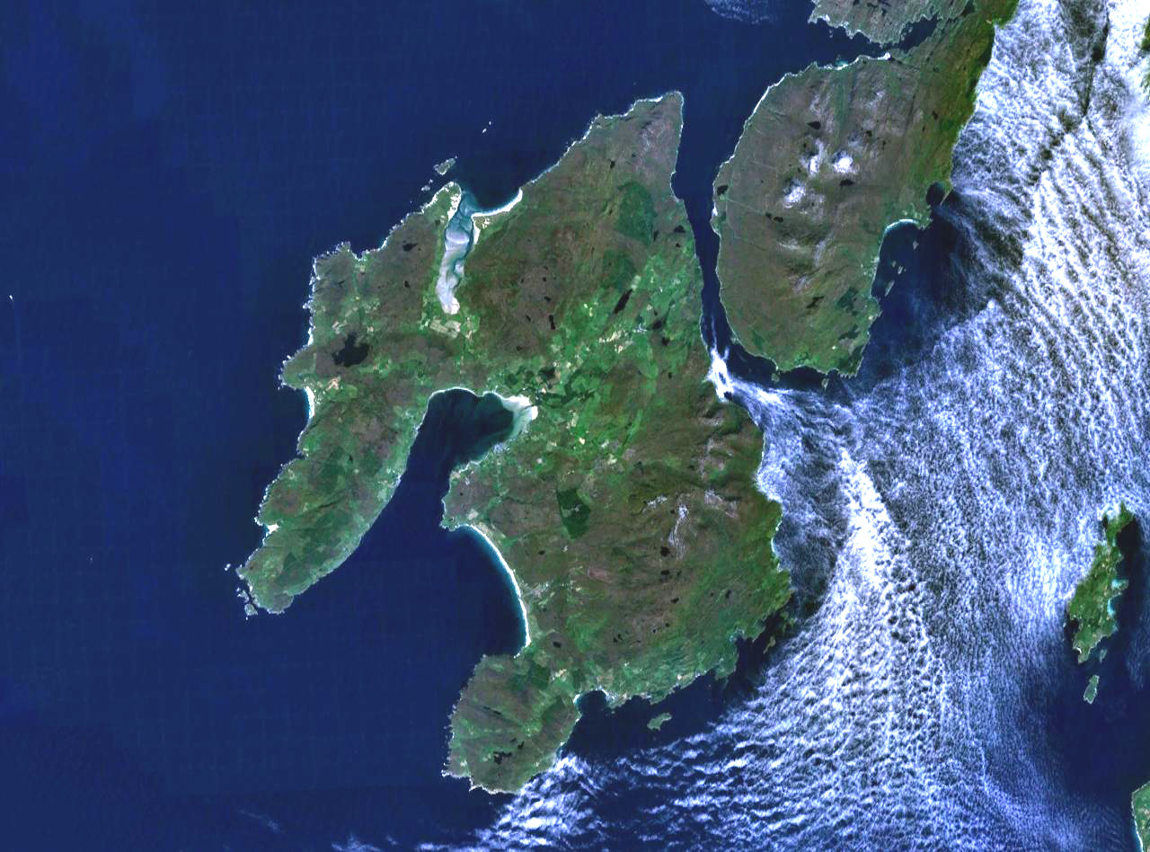
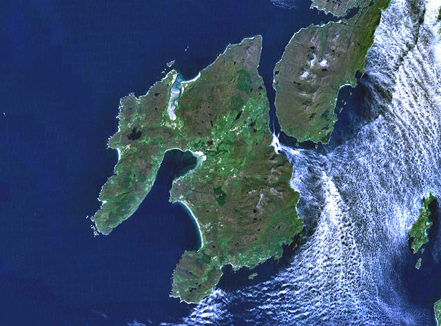
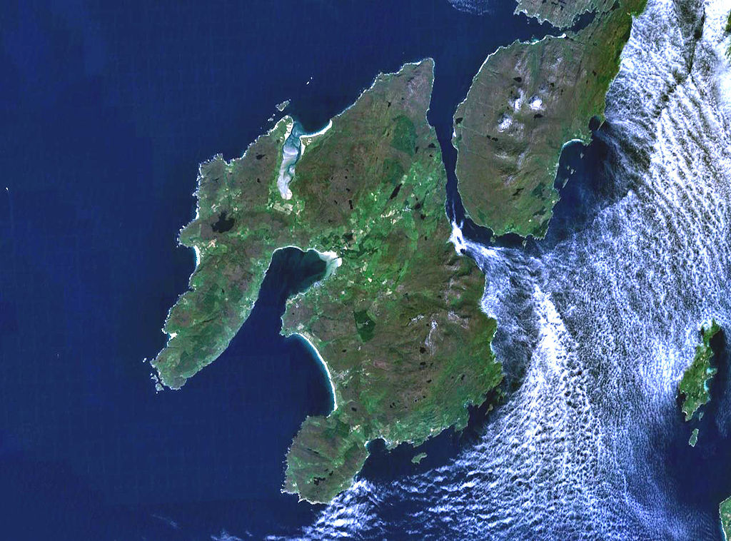
The island of Islay off the west coast of Scotland. The south part of the neighbouring island if Jura is visible to the northeast, and on the far east (right) of frame is the small island of Gigha.
Landsat 7 image, collected using NASA World Wind.

Lizenz[Bearbeiten]
| Diese Datei ist gemeinfrei (Public Domain), da es sich um einen Screenshot der NASA-Software World Wind handelt, in der ein gemeinfreier Datensatz wie Blue Marble, MODIS, Landsat, SRTM, USGS oder GLOBE verwendet wird.
|
 |
Dateiversionen
Klicke auf einen Zeitpunkt, um diese Version zu laden.
| Version vom | Vorschaubild | Maße | Benutzer | Kommentar | |
|---|---|---|---|---|---|
| aktuell | 19:28, 4. Aug. 2005 | | 1.280 × 948 (285 KB) | Finlay McWalter (Diskussion | Beiträge) | The island of Islay off the west coast of Scotland. Landsat 7 image, collected using NASA World Wind. {{PD-USGov-NASA}} category:islands |
Du kannst diese Datei nicht überschreiben.
Dateiverwendung
Die folgenden 16 Seiten verwenden diese Datei:
- Wikimedia logo mosaic
- Wikimedia logo mosaic/A-Z gallery/W-...
- Wikimedia logo mosaic/Colours gallery/Blue
- User:Ash Crow/test
- User:Bugboy52.4
- User:Cyc~commonswiki
- User:Lar/Mosaic2
- User:OhanaUnited/Wikispecies logo mosaic
- User:Prolineserver/mosaic
- User:Przykuta/Gender mosaic
- User:Twice25/Mosaic
- User talk:Symode09/Large
- Commons:STOP!!!! DO NOT DELETE THIS IMAGE TILL YOU REPLACE IT IN THE WIKIMEDIA LOGO MOSAIC
- Category:Islay
- Category:Maps of Islay
- Category:Villages on Islay
Globale Dateiverwendung
Die nachfolgenden anderen Wikis verwenden diese Datei:
- Verwendung auf arz.wikipedia.org
- Verwendung auf br.wikipedia.org
- Verwendung auf ca.wikipedia.org
- Verwendung auf cy.wikipedia.org
- Verwendung auf da.wikipedia.org
- Verwendung auf de.wikipedia.org
- Verwendung auf de.wikivoyage.org
- Verwendung auf en.wikipedia.org
- Islay single malts
- Lagavulin distillery
- Port Ellen
- Port Ellen distillery
- Bowmore distillery
- Lagavulin
- Laphroaig distillery
- User:Chino
- Islay Airport
- Ardbeg distillery
- Bowmore
- Bruichladdich distillery
- Kilchoman distillery
- Port Charlotte, Islay
- Caol Ila distillery
- Port Askaig
- Portnahaven
- The Oa
- Rinns of Islay
- Bridgend, Islay
- Bunnahabhain
- User:Mike McGregor (Can)
- User:Pradiptaray
- Kilarrow Parish Church
- Eilean Mhic Coinnich
- Easter Ellister
- Ballygrant
- User:Tomyumgoong
- User:MJBurrage
- User:Svartalf
- User:UBX/User prefers Islay Malts
- User:Mike McGregor (Can)/code page
- User:A435(m)
- User:Jgp
- User:CzechOut
- User:Lindisfarne~enwiki
- User:AndreaPersephone
- User:NJW494
- User:AlexTiefling
- User:J.P.Lon
Weitere globale Verwendungen dieser Datei anschauen.