File:White's 1873 map of WV counties of Clay, Webster, Nicholas, Fayette.jpg
Jump to navigation
Jump to search

Size of this preview: 695 × 599 pixels. Other resolutions: 278 × 240 pixels | 557 × 480 pixels | 890 × 768 pixels | 1,187 × 1,024 pixels | 2,374 × 2,048 pixels | 5,960 × 5,141 pixels.
Original file (5,960 × 5,141 pixels, file size: 16.25 MB, MIME type: image/jpeg)
Captions
Captions
Add a one-line explanation of what this file represents
Summary[edit]
| Warning | The original file is very high-resolution. It might not load properly or could cause your browser to freeze when opened at full size. |
|---|
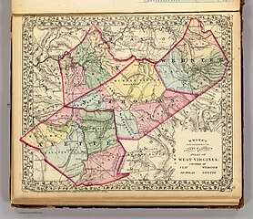
| Title |
White's topographical, county & district atlas of West Virginia. Counties of Clay, Webster, Nicholas, Fayette. Entered according to Act of Congress in the year 1873 by M. Wood White in the Office of the Librarian of Congress at Washington. |
|||||||||
| Description |
Lithographed map. Hand colored. Relief shown by hachures. Shows townships, settlements, railroad, etc. Ornamental border. |
|||||||||
| Date | ||||||||||
| Source | https://www.davidrumsey.com/luna/servlet/detail/RUMSEY~8~1~28427~1120361 | |||||||||
| Creator |
White, M. Wood |
|||||||||
| Permission (Reusing this file) |
|
|||||||||
| Geotemporal data | ||||||||||
| Scale | 1:338,000 | |||||||||
| Bounding box |
|
|||||||||
| Georeferencing | ||||||||||
| Place of publication | Grafton, WV | |||||||||
| Archival data | ||||||||||
| Collection | David Rumsey Historical Map Collection | |||||||||
| Dimensions | 40 × 34 cm (15.7 × 13.3 in) | |||||||||
| Notes | Part of White's new county and district atlas of the state of West Virginia. Comprising fifty-four counties; three hundred and twenty-seven township districts; and two thousand five hundred and sixty-seven school districts. From the most recent surveys and authentic sources. Maps drawn by William H. Gamble, Philadelphia, Penna. Examined and corrected by M.A. Miller, top. eng., Staunton, Virginia. Grafton, West Virginia: M. Wood White. Philadelphia: S.A. Mitchell. 1873. Entered ... 1873 by M. Wood White ... at Washington. | |||||||||
| artwork-references | Phillips, 2627; Phillips. Maps of America, p. 1068; LeGear. Atlases of the United States, 3408. | |||||||||
| Other versions | https://archive.org/details/dr_whites-topographical-county--district-atlas-of-west-virginia-counties-o-1199019 | |||||||||


File history
Click on a date/time to view the file as it appeared at that time.
| Date/Time | Thumbnail | Dimensions | User | Comment | |
|---|---|---|---|---|---|
| current | 15:10, 19 April 2023 | | 5,960 × 5,141 (16.25 MB) | Scewing (talk | contribs) | == {{int:filedesc}} == {{LargeImage}} {{Map |title =White's topographical, county & district atlas of West Virginia. Counties of Clay, Webster, Nicholas, Fayette. Entered according to Act of Congress in the year 1873 by M. Wood White in the Office of the Librarian of Congress at Washington. |description =Lithographed map. Hand colored. Relief shown by hachures. Shows townships, settlements, railroad, etc. Ornamental border. |author =White, M. Wood |date... |
You cannot overwrite this file.
File usage on Commons
The following page uses this file: