File:White Nile, Sudan ESA23823958.jpeg

Original file (5,188 × 4,625 pixels, file size: 29.14 MB, MIME type: image/jpeg)
Captions
Captions
Summary
[edit]
| Description |
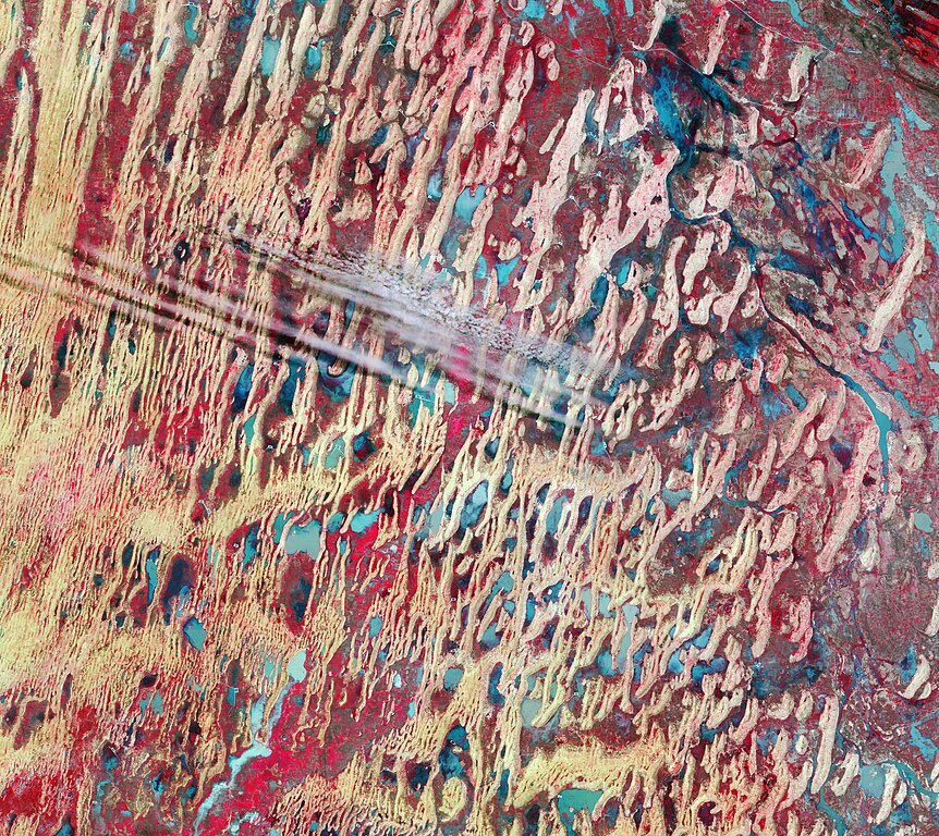
English: A part of the White Nile state in Sudan is featured in this false-colour image captured by the Copernicus Sentinel-2 mission. Zoom in to see this image at its full 10 m resolution or click on the circles to learn more about the features in it. White Nile is one of the 18 states of Sudan. Covering an area of around 40 000 sq km, the state is divided into four districts: Ad Douiem, Al Gutaina, Kosti and Al Jabalian. The area pictured here is located just north of Kosti, also spelled Kūstī, which lies on the west bank of the White Nile River (not visible). This false-colour image, captured on 25 August 2021, was processed in a way that also includes information from the near-infrared channel and shows vegetation in tones of red. This band combination is routinely used to monitor vegetation health. Although the area lies within an arid climatic region, low vegetation covering the valley floors between the sand dunes can be seen in bright shades of red. Many agricultural plots can also be seen in red, particularly in the far-right and far-bottom of the image. Agriculture plays an important role in Sudan’s economy. The country’s main crops include cotton, peanuts, sesame and sugarcane, while the main subsistence crops include wheat, corn, sorghum and millet. Several small villages can also be spotted in the image, with many of them visible near artificial water reservoirs (easily spotted with their rectangular shape) and are most likely utilised during the dry season. Owing to seasonal rainfall, many ephemeral bodies of water can be spotted in shades of turquoise and blue in the image. Flooding is common in Sudan in August and September. During these months each year, monsoon rains pour into the Ethiopian Highlands and flow down to the Blue and White Nile and can often lead to floodwaters swamping nearby communities. Starting in August 2021, a series of torrential downpours overwhelmed streams and rivers and unleashed floods in the area, with the White Nile being one of the hardest hit areas. Copernicus Sentinel-2 has two satellites, each carrying a high-resolution camera that images Earth’s surface in 13 spectral bands. The type of band combination from Copernicus Sentinel-2 used to process this image is commonly utilised to assess plant density and health, as plants reflect near-infrared and green light, while absorbing red. Since they reflect more near-infrared than green, dense, plant-covered land appears in bright red. This image is also featured on the Earth from Space video programme. |
| Date | 3 December 2021 (upload date) |
| Source | White Nile, Sudan |
| Author | European Space Agency |
| Activity | Observing the Earth |
| Mission | Sentinel-2 |
| Set | Earth observation image of the week |
| System | Copernicus |
Licensing
[edit]

|
This image contains data from a satellite in the Copernicus Programme, such as Sentinel-1, Sentinel-2 or Sentinel-3. Attribution is required when using this image.
Attribution: Contains modified Copernicus Sentinel data 2021
The use of Copernicus Sentinel Data is regulated under EU law (Commission Delegated Regulation (EU) No 1159/2013 and Regulation (EU) No 377/2014). Relevant excerpts:
Free access shall be given to GMES dedicated data [...] made available through GMES dissemination platforms [...].
Access to GMES dedicated data [...] shall be given for the purpose of the following use in so far as it is lawful:
GMES dedicated data [...] may be used worldwide without limitations in time.
GMES dedicated data and GMES service information are provided to users without any express or implied warranty, including as regards quality and suitability for any purpose. |
This media was created by the European Space Agency (ESA).
Where expressly so stated, images or videos are covered by the Creative Commons Attribution-ShareAlike 3.0 IGO (CC BY-SA 3.0 IGO) licence, ESA being an Intergovernmental Organisation (IGO), as defined by the CC BY-SA 3.0 IGO licence. The user is allowed under the terms and conditions of the CC BY-SA 3.0 IGO license to Reproduce, Distribute and Publicly Perform the ESA images and videos released under CC BY-SA 3.0 IGO licence and the Adaptations thereof, without further explicit permission being necessary, for as long as the user complies with the conditions and restrictions set forth in the CC BY-SA 3.0 IGO licence, these including that:
See the ESA Creative Commons copyright notice for complete information, and this article for additional details.
|
 | |
This file is licensed under the Creative Commons Attribution-ShareAlike 3.0 IGO license. Attribution: ESA, CC BY-SA IGO 3.0
| ||
File history
Click on a date/time to view the file as it appeared at that time.
| Date/Time | Thumbnail | Dimensions | User | Comment | |
|---|---|---|---|---|---|
| current | 10:01, 3 December 2021 | | 5,188 × 4,625 (29.14 MB) | OptimusPrimeBot (talk | contribs) | #Spacemedia - Upload of https://www.esa.int/var/esa/storage/images/esa_multimedia/images/2021/12/white_nile_sudan/23823948-1-eng-GB/White_Nile_Sudan.jpg via Commons:Spacemedia |
You cannot overwrite this file.
File usage on Commons
There are no pages that use this file.