File:Whitstable MAP28 2400.jpg
Original file (2,400 × 1,260 pixels, file size: 2.19 MB, MIME type: image/jpeg)
Captions
Captions
| Description |
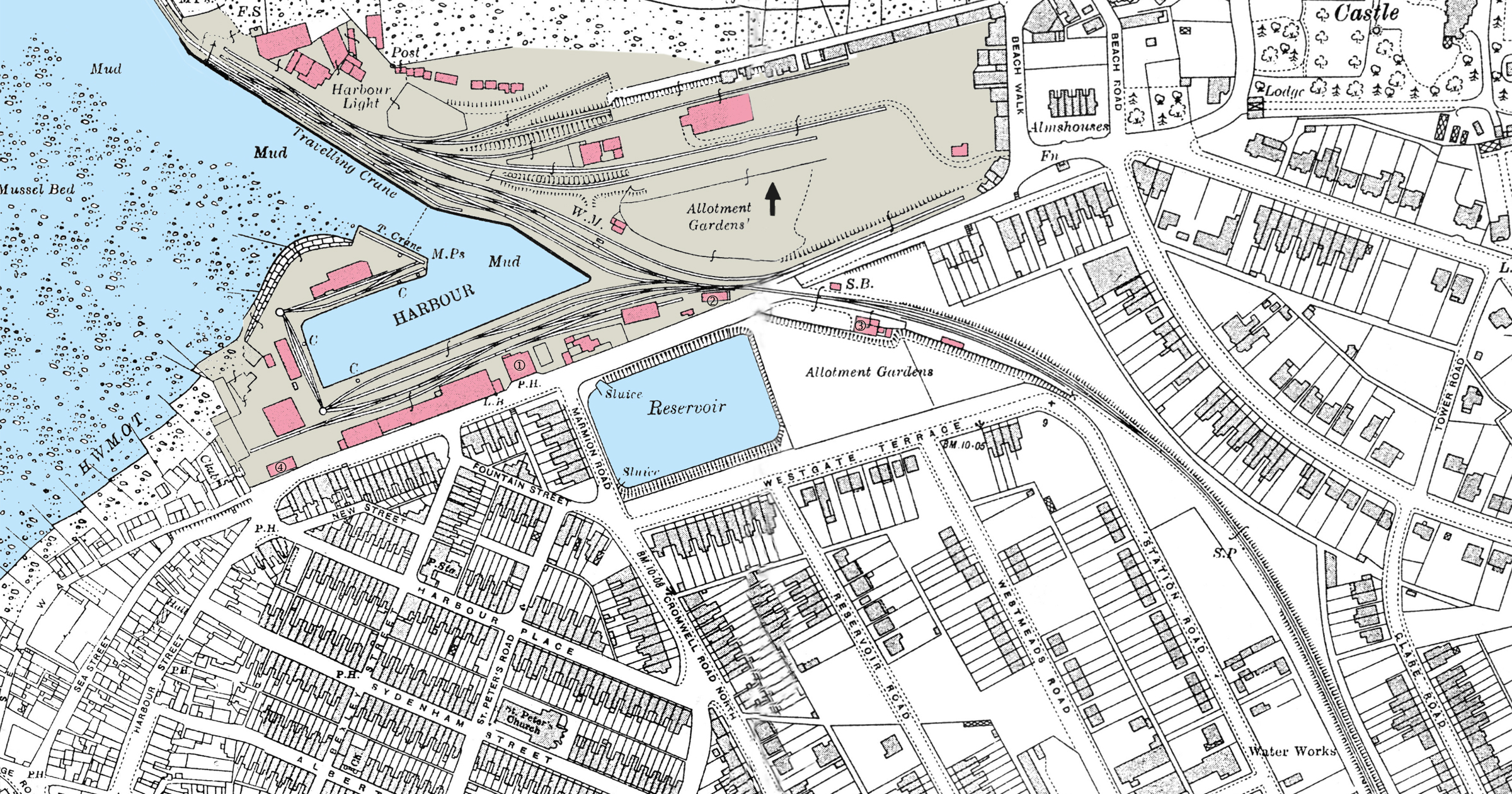
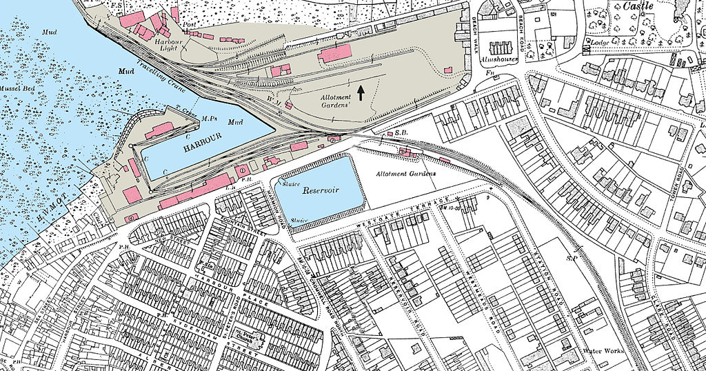
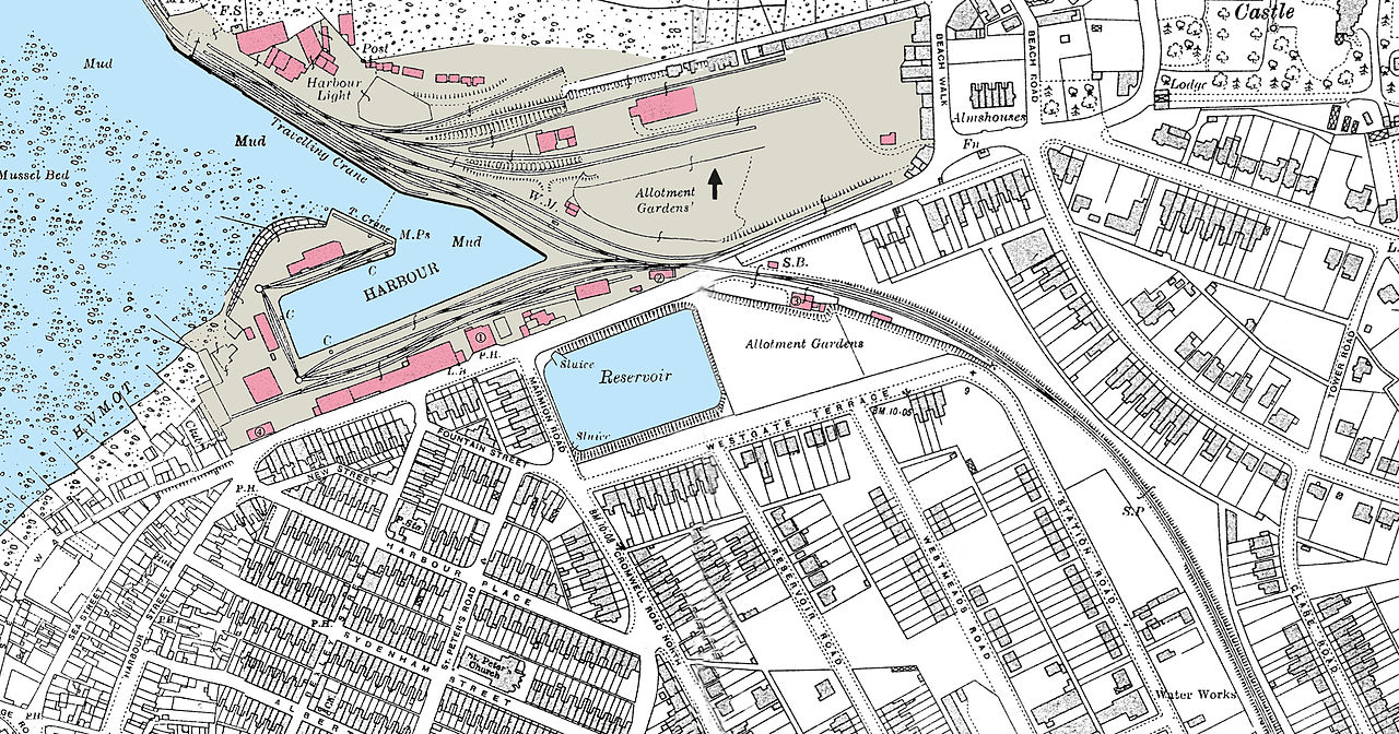
English: Whitstable Habour with Canterbury&Whitstable Railway, map 1938. (1) Railway station 1830, (2) R.S. 1846, (3) R.S. 1895, (4) Stable, (S.B.) Signal Box since 1908, (C) Crane, (W.M.) Weight bridge Deutsch: Whitstable Hafen mit Canterbury&Whitstable Railway, Karte 1938. (1) Empfangsgebäude 1830, (2) EG 1846, (3) EG 1895, (4) Stall, (S.B.) Stellwerk ab 1908, (C) Kran, (W.M.) Gleiswaage |
| Date | 1938, |
| Source | http://locodriver.co.uk/Railway_Encyclopedia/Part255/Part11/Part03/MAP28.jpg |
| Author | Unknown author |
| This is a retouched picture, which means that it has been digitally altered from its original version. Modifications made by Lantus (talk.
|
|
This work is in the public domain in its country of origin and other countries and areas where the copyright term is the author's life plus 70 years or fewer.
| |
| This file has been identified as being free of known restrictions under copyright law, including all related and neighboring rights. | |
| This work is ineligible for copyright and therefore in the public domain because it consists entirely of information that is common property and contains no original authorship. |

|
This photo, this drawing or graph was taken by Lantus. If you use one of my photos, drawings or graphs, an email (account needed) or a message would be greatly appreciated. |
File history
Click on a date/time to view the file as it appeared at that time.
| Date/Time | Thumbnail | Dimensions | User | Comment | |
|---|---|---|---|---|---|
| current | 19:34, 26 August 2014 | | 2,400 × 1,260 (2.19 MB) | Lantus (talk | contribs) | {{Information |Description={{en|Whitstable Habour with Canterbury&Whitstable Railway, map 1938. (1) Railway station 1830, (2) R.S. 1846, (3) R.S. 1895, (4) Stable, (S.B.) Signal Box since 1908, (C) Crane, (W.M.) Weight bridge}}{{de|Whitstable Hafen mit... |
You cannot overwrite this file.
File usage on Commons
The following page uses this file:
File usage on other wikis
The following other wikis use this file:
- Usage on de.wikipedia.org
- Usage on en.wikipedia.org
- Usage on www.wikidata.org