File:Wildfire in Evia, Greece - Image update (Copernicus).jpg

Original file (4,010 × 2,540 pixels, file size: 8.16 MB, MIME type: image/jpeg)
Captions
Captions
Summary
[edit].jpg&action=edit§ion=1)
| Description |
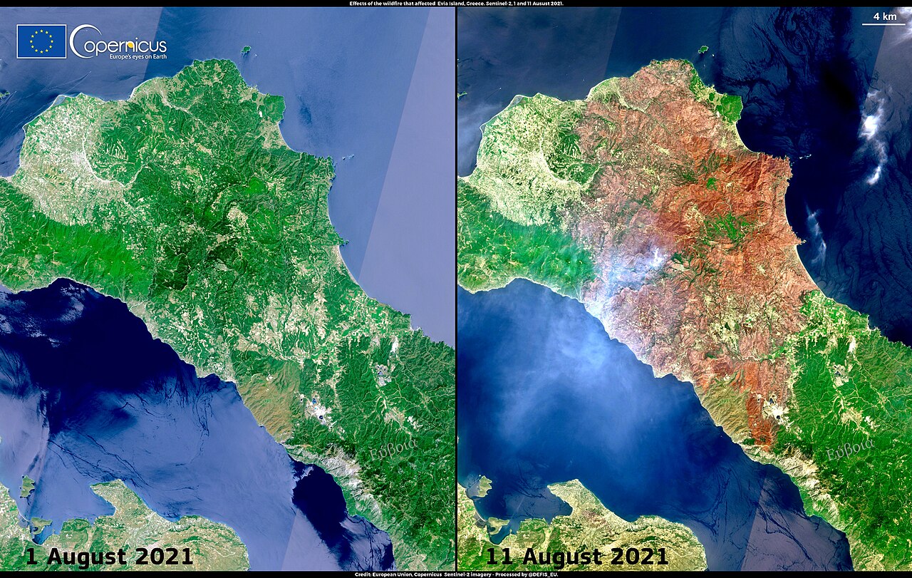
English: These images, acquired by one of the Copernicus Sentinel-2 satellites on 1 August and 11 August 2021, provide a view of the burnt area resulting from the devastating wildfire that hit the Greek island of Evia. According to the data of the Rapid mapping module of the Copernicus Emergency Management Service (CEMS), 50,910 ha of vegetation were destroyed by the fire that broke out on 4 August. In spite of the relentless work of thousands of firefighters, while thousands of residents were evacuated, the fire was only partially contained after seven days. The situation has improved, also due to torrential rains that supported the fire-fighting activities. However, several lightning strikes have triggered new fires, which are also being contained. According to EFFIS, the European Forest Fire Information System, the risk of new fires in the coming days remains at “extreme danger” or “very extreme danger levels” for the area. |
| Date | Taken on 4 August 2021 |
| Source | Wildfire in Evia, Greece - Image update |
| Author | European Union, Copernicus Sentinel-2 imagery |
Licensing
[edit].jpg&action=edit§ion=2)

|
This image contains data from a satellite in the Copernicus Programme, such as Sentinel-1, Sentinel-2 or Sentinel-3. Attribution is required when using this image.
Attribution: Contains modified Copernicus Sentinel data 2021
The use of Copernicus Sentinel Data is regulated under EU law (Commission Delegated Regulation (EU) No 1159/2013 and Regulation (EU) No 377/2014). Relevant excerpts:
Free access shall be given to GMES dedicated data [...] made available through GMES dissemination platforms [...].
Access to GMES dedicated data [...] shall be given for the purpose of the following use in so far as it is lawful:
GMES dedicated data [...] may be used worldwide without limitations in time.
GMES dedicated data and GMES service information are provided to users without any express or implied warranty, including as regards quality and suitability for any purpose. |
File history
Click on a date/time to view the file as it appeared at that time.
| Date/Time | Thumbnail | Dimensions | User | Comment | |
|---|---|---|---|---|---|
| current | 14:51, 9 September 2023 | | 4,010 × 2,540 (8.16 MB) | OptimusPrimeBot (talk | contribs) | #Spacemedia - Upload of https://www.copernicus.eu/system/files/2021-08/image_day/20210812_EviaWildfire.jpg via Commons:Spacemedia |
You cannot overwrite this file.
File usage on Commons
There are no pages that use this file.
.jpg&oldid=800010738)